
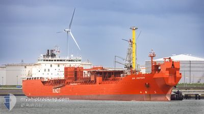
SIRI KNUTSEN
Well Stimulation Vessel
Current Trip
DE RUYTER OIL FIELD
| Time Travelled | 9 days |
|---|---|
| Remaining Time | --- |
| Distance Travelled | 218.77 nm |
| Remaining Distance | --- |
| AVG Speed | 9 Knop |
| MAX Speed | 12.7 Knop |
| AVG Wind | 13 knots |
| MAX Wind | 20.9 knots |
| MIN Temp | 12.1°C / 53.78°F |
| MAX Temp | 16.7°C / 62.06°F |
| Djupgående | 7.5 m |
| Position mottagen | 1 m sen |
Current Position
| Longitud | 9.59167° |
|---|---|
| Latitude | 57.84533° |
| Status | Under way using engine |
| Fart | 8.1 Knop |
| Kurs | 272° |
| Område | Skaggerak |
| Station | T-AIS |
| Position mottagen | 1 m sen |
Info
Information
The current position of SIRI KNUTSEN is in Skaggerak with coordinates 57.84533° / 9.59167° as reported on 2024-05-22 23:05 by AIS to our vessel tracker app. The vessel's current speed is 8.1 Knop
The vessel SIRI KNUTSEN (IMO: 9247168, MMSI: 257562000) is a Well Stimulation Vessel that was built in 2004 ( 20 År gammal ). It's sailing under the flag of [NO] Norway.
In this page you can find informations about the vessels current position, last detected port calls, and current voyage information. If the vessels is not in coverage by AIS you will find the latest position.
The current position of SIRI KNUTSEN is detected by our AIS receivers and we are not responsible for the reliability of the data. The last position was recorded while the vessel was in Coverage by the Ais receivers of our vessel tracking app.
The current draught of SIRI KNUTSEN as reported by AIS is 7.5 meters
Weather
| Temperature | 15.2°C / 59.36°F |
|---|---|
| Wind Speed | 14 knots |
| Direction | 100° E |
| Pressure | 1013.9 hPa |
| Humidity | 76 % |
| Cloud Coverage | 84 % |
Featured Company
Last Port Calls
| Port | Arrival | Departure | Time In Port |
|---|---|---|---|
| 2024-05-12 20:41 | 2024-05-13 12:36 | 15 h | |
| 2024-05-04 18:20 | 2024-05-05 23:49 | 1 d | |
| 2024-04-23 06:19 | 2024-04-24 09:01 | 1 d | |
| 2024-04-07 19:22 | 2024-04-09 21:35 | 2 d | |
| 2024-03-12 13:36 | 2024-03-13 15:14 | 1 d | |
| 2024-03-01 10:48 |
Most Visited Ports (Last year)
| Port | Arrivals | |
|---|---|---|
| 16 | ||
| 3 | ||
| 2 | ||
| 1 | ||
| 1 | ||
| 1 |
Last Trips
| Origin | Departure | Destination | Arrival | Distance | |
|---|---|---|---|---|---|
| 2024-05-06 01:49 | 2024-05-12 22:41 | 912.15 nm | |||
| 2024-04-24 11:01 | 2024-05-04 20:20 | 1352.85 nm | |||
| 2024-04-09 23:35 | 2024-04-23 08:19 | 1404.69 nm | |||
| 2024-03-13 16:14 | 2024-04-07 21:22 | 1459.75 nm | |||
| 2024-03-01 11:48 | 2024-03-12 14:36 | 899.00 nm |
Events
| Tid | Event | Detaljer | Position / Dest | Information |
|---|---|---|---|---|
| 2024-05-22 17:52 | Byter havsområde | Danish part of the Skaggerak Danish part of the Kattegat |
57.77500 / 10.79617
Skaggerak
|
Fart: 7.6 kn Kurs: 2° |
| 2024-05-22 17:02 | STARTAR förflyttning | 4.88 nm, South East of SKAGEN |
57.68200 / 10.73567
DE RUYTER OIL FIELD
|
Fart: 4.7 kn Kurs: 27° |
| 2024-05-22 17:00 | Destination ändrad | DE RUYTER OIL FIELD SKAGEN |
57.68017 / 10.73433
DE RUYTER OIL FIELD
|
Fart: 3.3 kn Kurs: 34° |
| 2024-05-22 16:48 | Status ändrad | Under way using engine At anchor |
57.68083 / 10.73217
SKAGEN
|
Fart: 0.3 kn Kurs: 176° |
| 2024-05-21 17:30 | Status ändrad | At anchor Default |
57.68150 / 10.73250
SKAGEN
|
Fart: 0.1 kn Kurs: 164° |
| 2024-05-21 17:24 | Status ändrad | Default At anchor |
57.68150 / 10.73250
SKAGEN
|
Fart: 0.1 kn Kurs: 164° |
| 2024-05-19 12:59 | Status ändrad | At anchor Default |
57.68200 / 10.73300
SKAGEN
|
Fart: 0.1 kn Kurs: 199° |
| 2024-05-19 12:57 | Status ändrad | Default At anchor |
57.68200 / 10.73300
SKAGEN
|
Fart: 0.1 kn Kurs: 199° |
| 2024-05-19 08:05 | Status ändrad | At anchor Default |
57.68200 / 10.73283
SKAGEN
|
Fart: 0.2 kn Kurs: 219° |
| 2024-05-19 08:02 | Status ändrad | Default At anchor |
57.68200 / 10.73333
SKAGEN
|
Fart: 0.2 kn Kurs: 208° |