

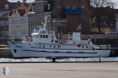
SEHO
Passengers Ship

Current Trip
HEILIGENHAFEN
| Time Travelled | 1 day |
|---|---|
| Remaining Time | --- |
| Distance Travelled | 48.04 nm |
| Remaining Distance | --- |
| AVG Speed | 5.5 Knop |
| MAX Speed | 7.3 Knop |
| AVG Wind | 12.9 knots |
| MAX Wind | 16.9 knots |
| MIN Temp | 11.9°C / 53.42°F |
| MAX Temp | 16.5°C / 61.7°F |
| Djupgående | 2 m |
| Position mottagen | 1 m sen |
Current Position
| Longitud | --- |
|---|---|
| Latitude | --- |
| Status | Under way using engine |
| Fart | 0.9 Knop |
| Kurs | 323° |
| Område | Baltic Sea |
| Station | T-AIS |
| Position mottagen | 1 m sen |
Information
The current position of SEHO is in Baltic Sea with coordinates 54.55348° / 11.10957° as reported on 2025-06-03 12:37 by AIS to our vessel tracker app. The vessel's current speed is 0.9 Knop
The vessel SEHO (IMO: 5104253, MMSI: 211226940) is a Passengers Ship that was built in 1962 ( 63 År gammal ). It's sailing under the flag of [DE] Germany.
In this page you can find informations about the vessels current position, last detected port calls, and current voyage information. If the vessels is not in coverage by AIS you will find the latest position.
The current position of SEHO is detected by our AIS receivers and we are not responsible for the reliability of the data. The last position was recorded while the vessel was in Coverage by the Ais receivers of our vessel tracking app.
The current draught of SEHO as reported by AIS is 2 meters
Weather
| Temperature | 16.4°C / 61.52°F |
|---|---|
| Wind Speed | 7 knots |
| Direction | 202° SSW |
| Pressure | 1011.7 hPa |
| Humidity | 64.4 % |
| Cloud Coverage | 35 % |


Featured Company
Last Port Calls
| Port | Arrival | Departure | Time In Port |
|---|---|---|---|
| 2025-05-31 14:47 | 2025-06-02 05:50 | 1 d | |
| 2025-05-31 12:37 | 2025-05-31 13:46 | 1 h | |
| 2025-05-31 11:09 | 2025-05-31 12:20 | 1 h | |
| 2025-05-30 14:52 | 2025-05-31 10:52 | 19 h | |
| 2025-05-30 12:41 | 2025-05-30 13:46 | 1 h | |
| 2025-05-30 11:35 | 2025-05-30 12:24 | 48 m | |
| 2025-05-29 14:51 | 2025-05-30 09:14 | 18 h | |
| 2025-05-29 12:46 | 2025-05-29 13:47 | 1 h | |
| 2025-05-29 11:08 | 2025-05-29 12:20 | 1 h | |
| 2025-05-29 09:41 | 2025-05-29 10:48 | 1 h |
Most Visited Ports (Last year)
| Port | Arrivals | |
|---|---|---|
| 435 | ||
| 13 | ||
| 1 | ||
| 1 | ||
| 1 |
Last Trips
| Origin | Departure | Destination | Arrival | Distance | |
|---|---|---|---|---|---|
| 2025-05-31 15:46 | 2025-05-31 16:47 | 7.48 nm | |||
| 2025-05-31 14:20 | 2025-05-31 14:37 | 1.72 nm | |||
| 2025-05-31 12:52 | 2025-05-31 13:09 | 1.81 nm | |||
| 2025-05-30 15:46 | 2025-05-30 16:52 | 7.68 nm | |||
| 2025-05-30 14:24 | 2025-05-30 14:41 | 1.88 nm | |||
| 2025-05-30 11:14 | 2025-05-30 13:35 | 17.30 nm | |||
| 2025-05-29 15:47 | 2025-05-29 16:51 | 7.84 nm | |||
| 2025-05-29 14:20 | 2025-05-29 14:46 | 2.69 nm | |||
| 2025-05-29 12:48 | 2025-05-29 13:08 | 2.26 nm | |||
| 2025-05-29 11:21 | 2025-05-29 11:41 | 2.14 nm |
Events
| Tid | Event | Detaljer | Position / Dest | Information |
|---|---|---|---|---|
| 2025-06-03 11:57 | I täckningsområde |
54.55122 / 11.10409
Baltic Sea
|
Fart: 5.6 kn Kurs: 215.2° |
|
| 2025-06-03 07:32 | UTANFÖR täckningsområde |
54.57424 / 10.93079
Baltic Sea
|
Fart: 0.7 kn Kurs: 56.3° |
|
| 2025-06-03 07:18 | I täckningsområde |
54.57305 / 10.92726
Baltic Sea
|
Fart: 0.6 kn Kurs: 69.7° |
|
| 2025-06-03 04:31 | UTANFÖR täckningsområde |
54.38655 / 11.15180
Baltic Sea
|
Fart: 4.1 kn Kurs: 318.1° |
|
| 2025-06-03 04:28 | STARTAR förflyttning | 2.12 nm, South West of BURGSTAAKEN |
54.38422 / 11.15105
HEILIGENHAFEN
|
Fart: 3.8 kn Kurs: 52° |
| 2025-06-03 04:28 | Status ändrad | Under way using engine At anchor |
54.38399 / 11.15050
HEILIGENHAFEN
|
Fart: 0.3 kn Kurs: 320° |
| 2025-06-03 01:18 | Status ändrad | At anchor Default |
54.38329 / 11.14881
HEILIGENHAFEN
|
Fart: Kurs: 287° |
| 2025-06-03 01:12 | Status ändrad | Default At anchor |
54.38334 / 11.14876
HEILIGENHAFEN
|
Fart: Kurs: 286° |
| 2025-06-02 19:33 | Status ändrad | At anchor Under way using engine |
54.38336 / 11.14877
HEILIGENHAFEN
|
Fart: Kurs: 233° |
| 2025-06-02 17:11 | STOPPAR förflyttning | 2.22 nm, South West of BURGSTAAKEN |
54.38334 / 11.14831
HEILIGENHAFEN
|
Fart: 0.3 kn Kurs: 38° |