
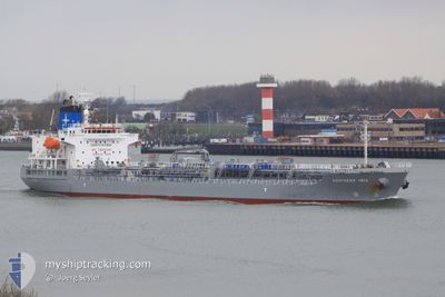
SAEHAN KOSTAR
Oil/Chemical Tanker
Current Trip
| Trip Time | 19 days |
|---|---|
| Trip Distance | 4031.82 nm |
| AVG Speed | 11.2 Knop |
| MAX Speed | 15.3 Knop |
| Djupgående | 10.2 m |
| AVG Wind | 9.8 knots |
| MAX Wind | 27 knots |
| MIN Temp | 17.5°C / 63.5°F |
| MAX Temp | 32.4°C / 90.32°F |
| Position mottagen | 2 d sen |
Current Position
| Longitud | 118.18345° |
|---|---|
| Latitude | 38.79937° |
| Status | Under way using engine |
| Fart | 9.7 Knop |
| Kurs | 314° |
| Område | Yellow Sea |
| Station | T-AIS |
| Position mottagen | 2 d sen |
Info
Information
The current position of SAEHAN KOSTAR is in Yellow Sea with coordinates 38.79937° / 118.18345° as reported on 2024-06-04 20:18 by AIS to our vessel tracker app. The vessel's current speed is 9.7 Knop and is currently inside the port of TIANJIN.
The vessel SAEHAN KOSTAR (IMO: 9423695, MMSI: 353608000) is a Oil/Chemical Tanker that was built in 2009 ( 15 År gammal ). It's sailing under the flag of [PA] Panama.
In this page you can find informations about the vessels current position, last detected port calls, and current voyage information. If the vessels is not in coverage by AIS you will find the latest position.
The current position of SAEHAN KOSTAR is detected by our AIS receivers and we are not responsible for the reliability of the data. The last position was recorded while the vessel was in Coverage by the Ais receivers of our vessel tracking app.
The current draught of SAEHAN KOSTAR as reported by AIS is 10.2 meters
Weather
| Temperature | 22.8°C / 73.04°F |
|---|---|
| Wind Speed | 9 knots |
| Direction | 195° SSW |
| Pressure | 1007.8 hPa |
| Humidity | 55.3 % |
| Cloud Coverage | 100 % |
Featured Company
Most Visited Ports (Last year)
| Port | Arrivals | |
|---|---|---|
| 5 | ||
| 3 | ||
| 3 | ||
| 2 | ||
| 2 | ||
| 2 |
Last Trips
| Origin | Departure | Destination | Arrival | Distance | |
|---|---|---|---|---|---|
| 2024-05-16 17:01 | 2024-06-05 09:47 | 4031.82 nm | |||
| 2024-04-30 20:18 | 2024-05-14 15:31 | 3080.95 nm | |||
| 2024-04-22 00:24 | 2024-04-29 23:11 | 2187.03 nm | |||
| 2024-04-15 01:56 | 2024-04-21 07:47 | 1237.19 nm | |||
| 2024-03-25 15:59 | 2024-04-13 02:04 | 1516.35 nm |
Events
| Tid | Event | Detaljer | Position / Dest | Information |
|---|---|---|---|---|
| 2024-06-05 02:34 | STOPPAR förflyttning |
38.98640 / 117.77943
[CN] TIANJIN
|
Fart: 0.2 kn Kurs: 345° |
|
| 2024-06-05 01:47 | ANLÄNDER HAMN |
|
38.95900 / 117.86690
[CN] TIANJIN
|
Fart: 12.2 kn Kurs: 275° |
| 2024-06-05 00:16 | STARTAR förflyttning | 16.67 nm, East of TIANJIN |
38.91210 / 118.09272
CN TXG
|
Fart: 4.9 kn Kurs: 20° |
| 2024-06-04 21:44 | STOPPAR förflyttning | 16.94 nm, East of TIANJIN |
38.90420 / 118.09603
CN TXG
|
Fart: 0.2 kn Kurs: 279° |
| 2024-06-04 20:24 | Status ändrad | Default Under way using engine |
38.80943 / 118.17033
CN TXG
|
Fart: 9.7 kn Kurs: 314° |
| 2024-06-04 20:18 | UTANFÖR täckningsområde |
38.79937 / 118.18345
Yellow Sea
CN TXG
|
Fart: 9.7 kn Kurs: 314° |
|
| 2024-06-04 19:52 | Upptäckt i hav | Chinese part of the Yellow Sea |
38.79623 / 118.26105
Yellow Sea
CN TXG
|
Fart: 9.8 kn Kurs: 233° |
| 2024-06-04 19:49 | Status ändrad | Under way using engine Default |
38.79970 / 118.26708
CN TXG
|
Fart: 9.8 kn Kurs: 232° |
| 2024-06-04 19:49 | I täckningsområde |
38.79623 / 118.26105
Yellow Sea
CN TXG
|
Fart: 9.8 kn Kurs: 233° |
|
| 2024-06-01 00:24 | UTANFÖR täckningsområde |
25.53290 / 121.03085
Eastern China Sea
CN TXG
|
Fart: 12.4 kn Kurs: 32° |