
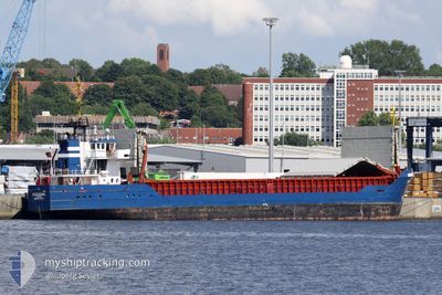
ROSEBURG
General Cargo
Current Trip
| Time Travelled | 1 day |
|---|---|
| Remaining Time | --- |
| Distance Travelled | 283.89 nm |
| Remaining Distance | --- |
| AVG Speed | 9.1 Knop |
| MAX Speed | 10 Knop |
| AVG Wind | 7.4 knots |
| MAX Wind | 13.3 knots |
| MIN Temp | 5°C / 41°F |
| MAX Temp | 8.8°C / 47.84°F |
| Djupgående | 4.9 m |
| Position mottagen | Nu |
Current Position
| Longitud | 21.49763° |
|---|---|
| Latitude | 59.02344° |
| Status | Under way using engine |
| Fart | 9.4 Knop |
| Kurs | 217.4° |
| Område | Baltic Sea |
| Station | T-AIS |
| Position mottagen | Nu |
Info
Information
The current position of ROSEBURG is in Baltic Sea with coordinates 59.02344° / 21.49763° as reported on 2024-05-12 17:10 by AIS to our vessel tracker app. The vessel's current speed is 9.4 Knop and is heading at the port of STRALSUND. The estimated time of arrival as calculated by MyShipTracking vessel tracking app is 2024-05-14 17:00 LT
The vessel ROSEBURG (IMO: 8817370, MMSI: 305184000) is a General Cargo that was built in 1991 ( 33 År gammal ). It's sailing under the flag of [AG] Antigua Barbuda.
In this page you can find informations about the vessels current position, last detected port calls, and current voyage information. If the vessels is not in coverage by AIS you will find the latest position.
The current position of ROSEBURG is detected by our AIS receivers and we are not responsible for the reliability of the data. The last position was recorded while the vessel was in Coverage by the Ais receivers of our vessel tracking app.
The current draught of ROSEBURG as reported by AIS is 4.9 meters
Weather
| Temperature | 8.2°C / 46.76°F |
|---|---|
| Wind Speed | 4 knots |
| Direction | 218° SW |
| Pressure | 1023.3 hPa |
| Humidity | 66.1 % |
| Cloud Coverage | 81 % |
Featured Company
Last Port Calls
| Port | Arrival | Departure | Time In Port |
|---|---|---|---|
| 2024-05-10 03:42 | 2024-05-11 10:26 | 1 d | |
| 2024-05-01 11:15 | 2024-05-01 21:11 | 9 h | |
| 2024-04-29 05:57 | 2024-04-29 12:32 | 6 h | |
| 2024-04-18 13:27 | 2024-04-21 14:22 | 3 d | |
| 2024-04-18 12:06 | 2024-04-18 12:25 | 19 m | |
| 2024-04-13 05:42 | 2024-04-13 12:39 | 6 h | |
| 2024-04-09 13:23 | |||
| 2024-03-29 04:28 | 2024-04-03 10:26 | 5 d | |
| 2024-03-24 23:13 | 2024-03-25 20:01 | 20 h | |
| 2024-03-22 03:54 | 2024-03-24 21:18 | 2 d |
Most Visited Ports (Last year)
| Port | Arrivals | |
|---|---|---|
| 11 | ||
| 8 | ||
| 6 | ||
| 6 | ||
| 5 | ||
| 5 |
Last Trips
| Origin | Departure | Destination | Arrival | Distance | |
|---|---|---|---|---|---|
| 2024-05-02 00:11 | 2024-05-10 06:42 | 181.44 nm | |||
| 2024-04-29 14:32 | 2024-05-01 14:15 | 428.67 nm | |||
| 2024-04-21 16:22 | 2024-04-29 07:57 | 889.58 nm | |||
| 2024-04-18 14:25 | 2024-04-18 15:27 | 7.27 nm | |||
| 2024-04-13 14:39 | 2024-04-18 14:06 | 130.22 nm | |||
| 2024-04-09 15:23 | 2024-04-13 07:42 | 706.39 nm | |||
| 2024-03-25 23:01 | 2024-03-29 05:28 | 706.58 nm | |||
| 2024-03-25 00:18 | 2024-03-25 02:13 | 12.07 nm | |||
| 2024-03-20 20:13 | 2024-03-22 06:54 | 157.26 nm | |||
| 2024-03-14 22:08 | 2024-03-18 15:13 | 602.73 nm |
Events
| Tid | Event | Detaljer | Position / Dest | Information |
|---|---|---|---|---|
| 2024-05-12 15:02 | Status ändrad | Under way using engine Default |
59.26083 / 21.94182
DESTL
|
Fart: 9 kn Kurs: 234° |
| 2024-05-12 15:01 | Status ändrad | Default Under way using engine |
59.26231 / 21.94579
DESTL
|
Fart: 9 kn Kurs: 233.5° |
| 2024-05-12 13:38 | Byter havsområde | Estonian part of the Baltic Sea Finnish part of the Baltic Sea |
59.38432 / 22.27797
Baltic Sea
DESTL
|
Fart: 9.1 kn Kurs: 232.5° |
| 2024-05-12 11:55 | Status ändrad | Under way using engine Default |
59.51956 / 22.70810
DESTL
|
Fart: 9.2 kn Kurs: 251° |
| 2024-05-12 11:25 | Status ändrad | Default Under way using engine |
59.54454 / 22.84999
DESTL
|
Fart: 9.3 kn Kurs: 252° |
| 2024-05-12 10:35 | Byter havsområde | Finnish part of the Baltic Sea Finnish part of the Gulf of Finland |
59.58301 / 23.09421
Baltic Sea
DESTL
|
Fart: 9.1 kn Kurs: 253.7° |
| 2024-05-12 09:40 | Status ändrad | Under way using engine Default |
59.62155 / 23.35565
DESTL
|
Fart: 9.3 kn Kurs: 253° |
| 2024-05-12 09:30 | I täckningsområde |
59.62145 / 23.35493
Gulf of Finland
DESTL
|
Fart: 9.2 kn Kurs: 254.2° |
|
| 2024-05-12 07:32 | Status ändrad | Default Under way using engine |
59.71467 / 23.98644
DESTL
|
Fart: 9.2 kn Kurs: 252.5° |
| 2024-05-12 07:25 | UTANFÖR täckningsområde |
59.72042 / 24.02300
Gulf of Finland
DESTL
|
Fart: 9.2 kn Kurs: 252.5° |