

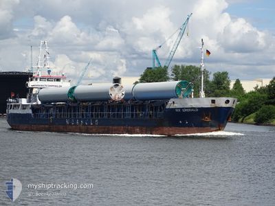
RIX EMERALD
General Cargo

Current Trip
| Time Travelled | 1 day |
|---|---|
| Remaining Time | 2 days |
| Distance Travelled | 247.04 nm |
| Remaining Distance | 389.42 nm |
| AVG Speed | 7.2 Knop |
| MAX Speed | 10.6 Knop |
| AVG Wind | 12.5 knots |
| MAX Wind | 24 knots |
| MIN Temp | -2.4°C / 27.68°F |
| MAX Temp | 4.6°C / 40.28°F |
| Djupgående | 4.7 m |
| Position mottagen | 1 m sen |
Current Position
| Longitud | --- |
|---|---|
| Latitude | --- |
| Status | Under way using engine |
| Fart | 7 Knop |
| Kurs | 100.8° |
| Område | Baltic Sea |
| Station | T-AIS |
| Position mottagen | 1 m sen |
Information
The current position of RIX EMERALD is in Baltic Sea with coordinates 54.40985° / 11.80656° as reported on 2025-02-21 00:58 by AIS to our vessel tracker app. The vessel's current speed is 7 Knop and is heading at the port of NORRKOPING. The estimated time of arrival as calculated by MyShipTracking vessel tracking app is 2025-02-23 12:56 LT
The vessel RIX EMERALD (IMO: 9116802, MMSI: 209014000) is a General Cargo that was built in 1995 ( 30 År gammal ). It's sailing under the flag of [CY] Cyprus.
In this page you can find informations about the vessels current position, last detected port calls, and current voyage information. If the vessels is not in coverage by AIS you will find the latest position.
The current position of RIX EMERALD is detected by our AIS receivers and we are not responsible for the reliability of the data. The last position was recorded while the vessel was in Coverage by the Ais receivers of our vessel tracking app.
The current draught of RIX EMERALD as reported by AIS is 4.7 meters
Weather
| Temperature | 1.9°C / 35.42°F |
|---|---|
| Wind Speed | 17 knots |
| Direction | 175° S |
| Pressure | 1022.5 hPa |
| Humidity | 81.7 % |
| Cloud Coverage | 100 % |


Featured Company
Last Port Calls
| Port | Arrival | Departure | Time In Port |
|---|---|---|---|
| 2025-02-17 18:52 | 2025-02-19 14:41 | 1 d | |
| 2025-02-08 10:36 | 2025-02-14 16:08 | 6 d | |
| 2025-02-05 17:58 | 2025-02-07 13:46 | 1 d | |
| 2025-02-03 16:54 | 2025-02-04 16:57 | 1 d | |
| 2025-01-29 21:24 | 2025-02-02 04:52 | 3 d | |
| 2025-01-27 05:42 | 2025-01-27 23:02 | 17 h | |
| 2025-01-25 05:29 | 2025-01-26 08:09 | 1 d | |
| 2025-01-23 14:36 | 2025-01-24 13:48 | 23 h | |
| 2025-01-21 05:29 | 2025-01-21 16:03 | 10 h | |
| 2025-01-18 11:45 | 2025-01-20 16:06 | 2 d |
Last Trips
| Origin | Departure | Destination | Arrival | Distance | |
|---|---|---|---|---|---|
| 2025-02-14 17:08 | 2025-02-17 19:52 | 274.29 nm | |||
| 2025-02-07 14:46 | 2025-02-08 11:36 | 110.32 nm | |||
| 2025-02-04 17:57 | 2025-02-05 18:58 | 210.10 nm | |||
| 2025-02-02 06:52 | 2025-02-03 17:54 | 285.00 nm | |||
| 2025-01-28 00:02 | 2025-01-29 23:24 | 264.73 nm | |||
| 2025-01-26 09:09 | 2025-01-27 06:42 | 140.92 nm | |||
| 2025-01-24 14:48 | 2025-01-25 06:29 | 122.98 nm | |||
| 2025-01-21 17:03 | 2025-01-23 15:36 | 349.02 nm | |||
| 2025-01-20 17:06 | 2025-01-21 06:29 | 100.58 nm | |||
| 2025-01-13 19:59 | 2025-01-18 12:45 | 946.11 nm |
Events
| Tid | Event | Detaljer | Position / Dest | Information |
|---|---|---|---|---|
| 2025-02-20 22:49 | Byter havsområde | Danish part of the Baltic Sea German part of the Baltic Sea |
54.50944 / 11.42497
Baltic Sea
SENRK VIA NOK
|
Fart: 6.6 kn Kurs: 115.1° |
| 2025-02-20 19:22 | Upptäckt i hav | German part of the Baltic Sea |
54.57399 / 10.78760
Baltic Sea
SENRK VIA NOK
|
Fart: 7.8 kn Kurs: 83.5° |
| 2025-02-20 18:25 | Upptäckt i hav | Danish part of the Baltic Sea |
54.55888 / 10.59570
Baltic Sea
SENRK VIA NOK
|
Fart: 6.9 kn Kurs: 67° |
| 2025-02-20 16:34 | Byter havsområde | German part of the Baltic Sea German part of the North Sea |
54.45857 / 10.26921
Baltic Sea
SENRK VIA NOK
|
Fart: 7 kn Kurs: 38.6° |
| 2025-02-20 15:30 | STARTAR förflyttning | 1.34 nm, South West of STICKENHΟRN SPORT |
54.36525 / 10.14460
SENRK VIA NOK
|
Fart: 3.1 kn Kurs: 105° |
| 2025-02-20 15:12 | STOPPAR förflyttning | 1.39 nm, South West of STICKENHΟRN SPORT |
54.36581 / 10.14101
SENRK VIA NOK
|
Fart: 0.2 kn Kurs: 104° |
| 2025-02-20 13:04 | STARTAR förflyttning | 2.09 nm, North East of BORGSTEDT |
54.35014 / 9.76860
SENRK VIA NOK
|
Fart: 4.4 kn Kurs: 41° |
| 2025-02-20 12:46 | STOPPAR förflyttning | 1.98 nm, North East of BORGSTEDT |
54.34878 / 9.76611
SENRK VIA NOK
|
Fart: 0.2 kn Kurs: 53° |
| 2025-02-20 09:52 | STARTAR förflyttning | 2.74 nm, North East of FISCHERHUTTE |
54.17281 / 9.44427
SENRK VIA NOK
|
Fart: 3.2 kn Kurs: 61° |
| 2025-02-20 09:29 | STOPPAR förflyttning | 2.53 nm, North East of FISCHERHUTTE |
54.17118 / 9.43883
SENRK VIA NOK
|
Fart: 0.3 kn Kurs: 58° |