

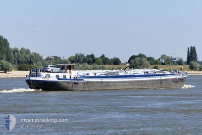
RENSKE
Tanker

Current Trip
| Trip Time | 10 h, 56 mins |
|---|---|
| Trip Distance | 56.18 nm |
| AVG Speed | 6.3 Knop |
| MAX Speed | 8.3 Knop |
| Djupgående | 2 m |
| AVG Wind | 9.9 knots |
| MAX Wind | 12 knots |
| MIN Temp | 12.5°C / 54.5°F |
| MAX Temp | 21.4°C / 70.52°F |
| Position mottagen | 1 m sen |
Current Position
| Longitud | --- |
|---|---|
| Latitude | --- |
| Status | Engaged in Fishing |
| Fart | |
| Kurs | --- |
| Område | North Sea |
| Station | T-AIS |
| Position mottagen | 1 m sen |
Information
The current position of RENSKE is in North Sea with coordinates 51.21430° / 6.70176° as reported on 2025-03-23 22:13 by AIS to our vessel tracker app. The vessel's current speed is 0 Knop and is currently inside the port of NEUSS.
The vessel RENSKE (MMSI: 244730346) is a Tanker It's sailing under the flag of [NL] Netherlands.
In this page you can find informations about the vessels current position, last detected port calls, and current voyage information. If the vessels is not in coverage by AIS you will find the latest position.
The current position of RENSKE is detected by our AIS receivers and we are not responsible for the reliability of the data. The last position was recorded while the vessel was in Coverage by the Ais receivers of our vessel tracking app.
The current draught of RENSKE as reported by AIS is 2 meters
Weather
| Temperature | 12.1°C / 53.78°F |
|---|---|
| Wind Speed | 1 knots |
| Direction | 237° WSW |
| Pressure | 1009.2 hPa |
| Humidity | 80.5 % |
| Cloud Coverage | 100 % |


Featured Company
Last Port Calls
| Port | Arrival | Departure | Time In Port |
|---|---|---|---|
| 2025-03-21 19:08 | |||
| 2025-03-21 07:27 | 2025-03-21 08:12 | 45 m | |
| 2025-03-20 18:04 | 2025-03-21 05:02 | 10 h | |
| 2025-03-19 17:38 | 2025-03-20 07:20 | 13 h | |
| 2025-03-18 14:00 | 2025-03-18 14:25 | 24 m | |
| 2025-03-17 12:22 | 2025-03-18 03:16 | 14 h | |
| 2025-03-14 18:53 | 2025-03-15 05:17 | 10 h | |
| 2025-03-14 14:01 | 2025-03-14 14:42 | 41 m | |
| 2025-03-14 10:44 | 2025-03-14 11:09 | 25 m | |
| 2025-03-13 16:19 | 2025-03-13 17:00 | 41 m |
Most Visited Ports (Last year)
| Port | Arrivals | |
|---|---|---|
| 46 | ||
| 41 | ||
| 28 | ||
| 22 | ||
| 17 | ||
| 16 |
Last Trips
| Origin | Departure | Destination | Arrival | Distance | |
|---|---|---|---|---|---|
| 2025-03-21 09:12 | 2025-03-21 20:08 | 56.18 nm | |||
| 2025-03-21 06:02 | 2025-03-21 08:27 | 14.99 nm | |||
| 2025-03-20 08:20 | 2025-03-20 19:04 | 63.89 nm | |||
| 2025-03-18 15:25 | 2025-03-19 18:38 | 53.89 nm | |||
| 2025-03-18 04:16 | 2025-03-18 15:00 | 88.78 nm | |||
| 2025-03-15 06:17 | 2025-03-17 13:22 | 107.31 nm | |||
| 2025-03-14 15:42 | 2025-03-14 19:53 | 1.03 nm | |||
| 2025-03-14 12:09 | 2025-03-14 15:01 | 11.76 nm | |||
| 2025-03-13 18:00 | 2025-03-14 11:44 | 10.07 nm | |||
| 2025-03-13 06:51 | 2025-03-13 17:19 | 89.16 nm |
Events
| Tid | Event | Detaljer | Position / Dest | Information |
|---|---|---|---|---|
| 2025-03-21 19:55 | STOPPAR förflyttning |
51.21513 / 6.70062
[DE] NEUSS
|
Fart: 0.3 kn Kurs: 511° |
|
| 2025-03-21 19:52 | STARTAR förflyttning |
51.21689 / 6.69797
[DE] NEUSS
|
Fart: 4.8 kn Kurs: 170.8° |
|
| 2025-03-21 19:20 | STOPPAR förflyttning |
51.21852 / 6.69940
[DE] NEUSS
|
Fart: Kurs: 511° |
|
| 2025-03-21 19:08 | ANLÄNDER HAMN |
|
51.22313 / 6.71669
[DE] NEUSS
|
Fart: 5.7 kn Kurs: 216.2° |
| 2025-03-21 17:43 | Status ändrad | Engaged in Fishing Default |
51.29429 / 6.72389
HAFEN NEUSS HAFENBE
|
Fart: 6.3 kn Kurs: 215° |
| 2025-03-21 17:40 | Status ändrad | Default Engaged in Fishing |
51.29868 / 6.72877
HAFEN NEUSS HAFENBE
|
Fart: 6.7 kn Kurs: 183.5° |
| 2025-03-21 17:28 | Status ändrad | Engaged in Fishing Default |
51.31878 / 6.73554
HAFEN NEUSS HAFENBE
|
Fart: 6.3 kn Kurs: 150° |
| 2025-03-21 17:25 | Status ändrad | Default Engaged in Fishing |
51.32324 / 6.73312
HAFEN NEUSS HAFENBE
|
Fart: 6.3 kn Kurs: 125.7° |
| 2025-03-21 15:38 | I täckningsområde |
51.43495 / 6.71164
North Sea
HAFEN NEUSS HAFENBE
|
Fart: 6 kn Kurs: 160.4° |
|
| 2025-03-21 08:37 | UTANFÖR täckningsområde |
51.84634 / 6.13662
North Sea
HAFEN NEUSS HAFENBE
|
Fart: 7 kn Kurs: 102.3° |