
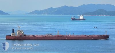
PLANET PEARL
Crude Oil Tanker
Current Trip
| Time Travelled | 14 days |
|---|---|
| Remaining Time | 26 mins |
| Distance Travelled | 2250.14 nm |
| Remaining Distance | 9.89 nm |
| AVG Speed | 9.7 Knop |
| MAX Speed | 13.9 Knop |
| AVG Wind | 6.3 knots |
| MAX Wind | 14.3 knots |
| MIN Temp | 26.3°C / 79.34°F |
| MAX Temp | 31°C / 87.8°F |
| Djupgående | 13.7 m |
| Position mottagen | 12 h, 15 m sen |
Current Position
| Longitud | 103.57260° |
|---|---|
| Latitude | 1.19519° |
| Status | Under way using engine |
| Fart | 10.5 Knop |
| Kurs | 290.4° |
| Område | Singapore Strait |
| Station | T-AIS |
| Position mottagen | 12 h, 15 m sen |
Info
Information
The current position of PLANET PEARL is in Singapore Strait with coordinates 1.19519° / 103.57260° as reported on 2024-06-09 22:51 by AIS to our vessel tracker app. The vessel's current speed is 10.5 Knop and is heading at the port of PORT DICKSON. The estimated time of arrival as calculated by MyShipTracking vessel tracking app is 2024-06-10 19:32 LT
The vessel PLANET PEARL (IMO: 9307140, MMSI: 371361000) is a Crude Oil Tanker that was built in 2005 ( 19 År gammal ). It's sailing under the flag of [PA] Panama.
In this page you can find informations about the vessels current position, last detected port calls, and current voyage information. If the vessels is not in coverage by AIS you will find the latest position.
The current position of PLANET PEARL is detected by our AIS receivers and we are not responsible for the reliability of the data. The last position was recorded while the vessel was in Coverage by the Ais receivers of our vessel tracking app.
The current draught of PLANET PEARL as reported by AIS is 13.7 meters
Weather
| Temperature | 30°C / 86°F |
|---|---|
| Wind Speed | 6 knots |
| Direction | 142° SE |
| Pressure | 1008.3 hPa |
| Humidity | 69.4 % |
| Cloud Coverage | 66 % |
Featured Company
Last Port Calls
| Port | Arrival | Departure | Time In Port |
|---|---|---|---|
| 2024-05-25 17:52 | 2024-05-27 00:49 | 1 d | |
| 2024-05-14 17:56 | 2024-05-16 00:48 | 1 d |
Most Visited Ports (Last year)
| Port | Arrivals | |
|---|---|---|
| 6 | ||
| 4 | ||
| 2 | ||
| 2 | ||
| 1 | ||
| 1 |
Last Trips
| Origin | Departure | Destination | Arrival | Distance | |
|---|---|---|---|---|---|
| 2024-05-16 00:48 | 2024-05-25 17:52 | 1865.09 nm | |||
| 2024-03-20 16:59 | 2024-05-14 17:56 | 4993.85 nm |
Events
| Tid | Event | Detaljer | Position / Dest | Information |
|---|---|---|---|---|
| 2024-06-09 22:57 | Status ändrad | Default Under way using engine |
1.20204 / 103.55431
MY PDI
|
Fart: 10.5 kn Kurs: 290.4° |
| 2024-06-09 22:51 | UTANFÖR täckningsområde |
1.19519 / 103.57260
Singapore Strait
MY PDI
|
Fart: 10.5 kn Kurs: 290.4° |
|
| 2024-06-09 22:46 | Byter havsområde | Malaysian part of the Singapore Strait Indonesian part of the Singapore Strait |
1.19083 / 103.58489
Singapore Strait
MY PDI
|
Fart: 10 kn Kurs: 285.8° |
| 2024-06-09 22:46 | Status ändrad | Under way using engine Default |
1.19083 / 103.58489
MY PDI
|
Fart: 10.1 kn Kurs: 285° |
| 2024-06-09 22:41 | Status ändrad | Default Under way using engine |
1.18836 / 103.59940
MY PDI
|
Fart: 9 kn Kurs: 276.7° |
| 2024-06-09 21:53 | Byter havsområde | Indonesian part of the Singapore Strait Singaporean part of the Singapore Strait |
1.15059 / 103.71048
Singapore Strait
MY PDI
|
Fart: 8.5 kn Kurs: 294.4° |
| 2024-06-09 19:08 | Byter havsområde | Singaporean part of the Singapore Strait Indonesian part of the Singapore Strait |
1.25925 / 104.00795
Singapore Strait
MY PDI
|
Fart: 8.5 kn Kurs: 261.9° |
| 2024-06-09 18:43 | Byter havsområde | Indonesian part of the Singapore Strait Malaysian part of the Singapore Strait |
1.26988 / 104.06710
Singapore Strait
MY PDI
|
Fart: 9.1 kn Kurs: 258.7° |
| 2024-06-09 18:41 | Djupgående ändrat | 13.7 8 |
1.27075 / 104.07161
MY PDI
|
Fart: 9 kn Kurs: 260.9° |
| 2024-06-09 18:41 | Destination ändrad | MY PDI MY KIKEH |
1.27075 / 104.07161
MY PDI
|
Fart: 9 kn Kurs: 260.9° |