
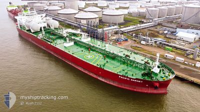
PACIFIC GARNET
Tanker
Current Trip
| Time Travelled | 27 days |
|---|---|
| Remaining Time | --- |
| Distance Travelled | 2785.08 nm |
| Remaining Distance | --- |
| AVG Speed | 7.9 Knop |
| MAX Speed | 13.7 Knop |
| AVG Wind | 20.4 knots |
| MAX Wind | 33 knots |
| MIN Temp | 1.8°C / 35.24°F |
| MAX Temp | 17.5°C / 63.5°F |
| Djupgående | 8.6 m |
| Position mottagen | 1 d sen |
Current Position
| Longitud | --- |
|---|---|
| Latitude | --- |
| Status | Under way using engine |
| Fart | 12.4 Knop |
| Kurs | 55.9° |
| Område | Black Sea |
| Station | T-AIS |
| Position mottagen | 1 d sen |
Info
Information
The current position of PACIFIC GARNET is in Black Sea with coordinates 41.41781° / 29.45921° as reported on 2025-02-15 08:11 by AIS to our vessel tracker app. The vessel's current speed is 12.4 Knop
The vessel PACIFIC GARNET (IMO: 9893084, MMSI: 538009203) is a Tanker It's sailing under the flag of [MH] Marshall Is.
In this page you can find informations about the vessels current position, last detected port calls, and current voyage information. If the vessels is not in coverage by AIS you will find the latest position.
The current position of PACIFIC GARNET is detected by our AIS receivers and we are not responsible for the reliability of the data. The last position was recorded while the vessel was in Coverage by the Ais receivers of our vessel tracking app.
The current draught of PACIFIC GARNET as reported by AIS is 8.6 meters
Weather
| Temperature | 3.7°C / 38.66°F |
|---|---|
| Wind Speed | 20 knots |
| Direction | 44° NE |
| Pressure | 1018.6 hPa |
| Humidity | 97.2 % |
| Cloud Coverage | 100 % |
Featured Company
Last Port Calls
| Port | Arrival | Departure | Time In Port |
|---|---|---|---|
| 2025-01-19 09:58 | 2025-01-20 15:35 | 1 d | |
| 2025-01-12 14:35 | 2025-01-12 15:52 | 1 h | |
| 2024-12-14 12:32 | 2024-12-16 06:29 | 1 d |
Most Visited Ports (Last year)
| Port | Arrivals | |
|---|---|---|
| 4 | ||
| 3 | ||
| 3 | ||
| 2 | ||
| 2 | ||
| 1 |
Last Trips
| Origin | Departure | Destination | Arrival | Distance | |
|---|---|---|---|---|---|
| 2025-01-12 15:52 | 2025-01-19 09:58 | 1235.18 nm | |||
| 2024-12-16 06:29 | 2025-01-12 14:35 | 2668.07 nm | |||
| 2024-11-22 18:20 | 2024-12-14 12:32 | 6028.08 nm |
Events
| Tid | Event | Detaljer | Position / Dest | Information |
|---|---|---|---|---|
| 2025-02-15 08:15 | Status ändrad | Default Under way using engine |
41.42780 / 29.47673
RUNVS
|
Fart: 12.4 kn Kurs: 55.9° |
| 2025-02-15 08:11 | UTANFÖR täckningsområde |
41.41781 / 29.45921
Black Sea
RUNVS
|
Fart: 12.4 kn Kurs: 55.9° |
|
| 2025-02-15 06:46 | Byter havsområde | Turkish part of the Black Sea Turkish part of the Sea of Marmara |
41.23226 / 29.14479
Black Sea
RUNVS
|
Fart: 11.9 kn Kurs: 47.5° |
| 2025-02-14 05:31 | STARTAR förflyttning | 17.92 nm, South West of AMBARLI |
40.71273 / 28.45276
RUNVS
|
Fart: 3.1 kn Kurs: 196° |
| 2025-02-14 03:52 | STOPPAR förflyttning | 17.4 nm, South West of AMBARLI |
40.71376 / 28.47158
RUNVS
|
Fart: 0.3 kn Kurs: 239° |
| 2025-02-13 15:50 | STARTAR förflyttning | 12.9 nm, South West of AMBARLI |
40.79158 / 28.49753
RUNVS
|
Fart: 3.1 kn Kurs: 236° |
| 2025-02-13 12:14 | STOPPAR förflyttning | 15.9 nm, South West of AMBARLI |
40.75045 / 28.45995
RUNVS
|
Fart: 0.3 kn Kurs: 206° |
| 2025-02-13 10:44 | STARTAR förflyttning | 12.85 nm, South West of AMBARLI |
40.77985 / 28.52078
RUNVS
|
Fart: 3.1 kn Kurs: 3° |
| 2025-02-13 09:10 | STOPPAR förflyttning | 13.92 nm, South West of AMBARLI |
40.76620 / 28.50548
RUNVS
|
Fart: 0.3 kn Kurs: 149° |
| 2025-02-13 07:34 | STARTAR förflyttning | 19.57 nm, South West of AMBARLI |
40.71692 / 28.38708
RUNVS
|
Fart: 3.2 kn Kurs: 12° |