
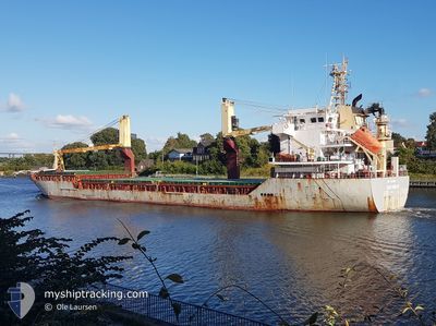
OSLO BULK 14
General Cargo
Current Trip
| Trip Time | 14 days |
|---|---|
| Trip Distance | 1560.00 nm |
| AVG Speed | 7.5 Knop |
| MAX Speed | 12.1 Knop |
| Djupgående | 4 m |
| AVG Wind | 15 knots |
| MAX Wind | 24 knots |
| MIN Temp | 15.2°C / 59.36°F |
| MAX Temp | 27.3°C / 81.14°F |
| Position mottagen | 21 d sen |
Current Position
| Longitud | --- |
|---|---|
| Latitude | --- |
| Status | Under way using engine |
| Fart | 11.5 Knop |
| Kurs | 316.4° |
| Område | Gulf of Mexico |
| Station | T-AIS |
| Position mottagen | 21 d sen |
Info
Information
The current position of OSLO BULK 14 is in Gulf of Mexico with coordinates 24.54265° / -83.40441° as reported on 2024-12-09 01:19 by AIS to our vessel tracker app. The vessel's current speed is 11.5 Knop and is currently inside the port of CAP HAITIEN.
The vessel OSLO BULK 14 (IMO: 9432490, MMSI: 259164000) is a General Cargo that was built in 2009 ( 15 År gammal ). It's sailing under the flag of [NO] Norway.
In this page you can find informations about the vessels current position, last detected port calls, and current voyage information. If the vessels is not in coverage by AIS you will find the latest position.
The current position of OSLO BULK 14 is detected by our AIS receivers and we are not responsible for the reliability of the data. The last position was recorded while the vessel was in Coverage by the Ais receivers of our vessel tracking app.
The current draught of OSLO BULK 14 as reported by AIS is 4 meters
Weather
| Temperature | 23.2°C / 73.76°F |
|---|---|
| Wind Speed | 5 knots |
| Direction | 114° ESE |
| Pressure | 1016.7 hPa |
| Humidity | 68.6 % |
| Cloud Coverage | 78 % |
Featured Company
Last Port Calls
| Port | Arrival | Departure | Time In Port |
|---|---|---|---|
| 2024-12-29 12:53 | |||
| 2024-12-10 14:59 | 2024-12-14 21:50 | 4 d | |
| 2024-12-04 16:39 | 2024-12-06 03:19 | 1 d | |
| 2024-11-19 07:33 | 2024-11-19 16:29 | 8 h | |
| 2024-11-17 19:42 | 2024-11-17 23:21 | 3 h | |
| 2024-11-17 08:45 | 2024-11-17 14:23 | 5 h | |
| 2024-11-14 06:49 | 2024-11-14 18:30 | 11 h | |
| 2024-11-08 00:31 | 2024-11-08 20:22 | 19 h | |
| 2024-10-31 09:27 | 2024-11-01 21:25 | 1 d | |
| 2024-10-26 12:21 | 2024-10-27 21:10 | 1 d |
Most Visited Ports (Last year)
| Port | Arrivals | |
|---|---|---|
| 5 | ||
| 4 | ||
| 4 | ||
| 4 | ||
| 3 | ||
| 3 |
Last Trips
| Origin | Departure | Destination | Arrival | Distance | |
|---|---|---|---|---|---|
| 2024-12-14 21:50 | 2024-12-29 12:53 | 1560.00 nm | |||
| 2024-12-06 03:19 | 2024-12-10 14:59 | 1113.14 nm | |||
| 2024-11-19 16:29 | 2024-12-04 16:39 | 2498.46 nm | |||
| 2024-11-17 23:21 | 2024-11-19 07:33 | 116.65 nm | |||
| 2024-11-17 14:23 | 2024-11-17 19:42 | 20.05 nm | |||
| 2024-11-14 18:30 | 2024-11-17 08:45 | 680.12 nm | |||
| 2024-11-08 20:22 | 2024-11-14 06:49 | 316.79 nm | |||
| 2024-11-01 21:25 | 2024-11-08 00:31 | 1419.96 nm | |||
| 2024-10-27 21:10 | 2024-10-31 09:27 | 76.34 nm | |||
| 2024-10-11 18:10 | 2024-10-26 12:21 | 2491.61 nm |
Events
| Tid | Event | Detaljer | Position / Dest | Information |
|---|---|---|---|---|
| 2024-12-29 17:53 | STOPPAR förflyttning |
19.75877 / -72.19359
[HT] CAP HAITIEN
|
Fart: 0.1 kn Kurs: 226° |
|
| 2024-12-29 17:53 | ANLÄNDER HAMN |
|
19.75877 / -72.19359
[HT] CAP HAITIEN
|
Fart: 1.7 kn Kurs: 234° |
| 2024-12-29 10:49 | STARTAR förflyttning | 6.55 nm, North of CAP HAITIEN |
19.85875 / -72.16118
USMOB
|
Fart: 6.4 kn Kurs: 184° |
| 2024-12-29 00:53 | STOPPAR förflyttning | 15.36 nm, North East of CAP HAITIEN |
19.95377 / -72.02563
USMOB
|
Fart: 0.3 kn Kurs: 58° |
| 2024-12-27 20:27 | STARTAR förflyttning | 15.4 nm, North of LABADIE |
20.03218 / -72.19213
USMOB
|
Fart: 5.5 kn Kurs: 74° |
| 2024-12-27 14:43 | STOPPAR förflyttning | 18 nm, North of LABADIE |
20.06099 / -72.13384
USMOB
|
Fart: 0.3 kn Kurs: 149° |
| 2024-12-27 04:28 | STARTAR förflyttning | 8.61 nm, North East of CAP HAITIEN |
19.88066 / -72.12360
USMOB
|
Fart: 6.4 kn Kurs: 34° |
| 2024-12-26 19:38 | STOPPAR förflyttning | 15.14 nm, North East of CAP HAITIEN |
19.97002 / -72.05631
USMOB
|
Fart: 0.3 kn Kurs: 151° |
| 2024-12-25 21:09 | STARTAR förflyttning |
20.16683 / -72.55724
USMOB
|
Fart: 4.3 kn Kurs: 108° |
|
| 2024-12-25 05:59 | STOPPAR förflyttning | 20.79 nm, North of LABADIE |
20.11201 / -72.35780
USMOB
|
Fart: 0.3 kn Kurs: 345° |