
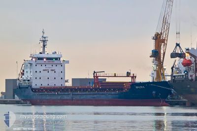
ORUBA
General Cargo
Current Trip
| Trip Time | 2 days |
|---|---|
| Trip Distance | 642.06 nm |
| AVG Speed | 8.5 Knop |
| MAX Speed | 10.1 Knop |
| Djupgående | 7.4 m |
| AVG Wind | 9 knots |
| MAX Wind | 27.5 knots |
| MIN Temp | 4.6°C / 40.28°F |
| MAX Temp | 15.1°C / 59.18°F |
| Position mottagen | Nu |
Current Position
| Longitud | --- |
|---|---|
| Latitude | --- |
| Status | Under way using engine |
| Fart | |
| Kurs | 22° |
| Område | Adriatic Sea |
| Station | T-AIS |
| Position mottagen | Nu |
Info
Information
The current position of ORUBA is in Adriatic Sea with coordinates 41.31078° / 19.45812° as reported on 2025-02-28 00:18 by AIS to our vessel tracker app. The vessel's current speed is 0 Knop and is currently inside the port of DURRES.
The vessel ORUBA (IMO: 9430624, MMSI: 636020511) is a General Cargo that was built in 2007 ( 18 År gammal ). It's sailing under the flag of [LR] Liberia.
In this page you can find informations about the vessels current position, last detected port calls, and current voyage information. If the vessels is not in coverage by AIS you will find the latest position.
The current position of ORUBA is detected by our AIS receivers and we are not responsible for the reliability of the data. The last position was recorded while the vessel was in Coverage by the Ais receivers of our vessel tracking app.
The current draught of ORUBA as reported by AIS is 7.4 meters
Weather
| Temperature | 12.3°C / 54.14°F |
|---|---|
| Wind Speed | 12 knots |
| Direction | 178° S |
| Pressure | 1017.7 hPa |
| Humidity | 80.7 % |
| Cloud Coverage | 100 % |
Featured Company
Last Port Calls
| Port | Arrival | Departure | Time In Port |
|---|---|---|---|
| 2025-02-27 09:01 | |||
| 2025-02-20 17:09 | 2025-02-24 09:19 | 3 d | |
| 2025-02-14 20:51 | 2025-02-17 01:39 | 2 d | |
| 2025-02-01 12:08 | 2025-02-06 13:28 | 5 d | |
| 2025-01-28 05:58 | 2025-01-29 00:07 | 18 h | |
| 2025-01-16 16:30 | 2025-01-16 20:00 | 3 h | |
| 2025-01-11 11:50 | 2025-01-12 19:19 | 1 d | |
| 2024-12-29 16:07 | 2024-12-31 06:37 | 1 d | |
| 2024-12-18 09:41 | 2024-12-19 21:32 | 1 d | |
| 2024-12-12 23:48 | 2024-12-15 19:48 | 2 d |
Last Trips
| Origin | Departure | Destination | Arrival | Distance | |
|---|---|---|---|---|---|
| 2025-02-24 12:19 | 2025-02-27 10:01 | 642.06 nm | |||
| 2025-02-17 04:39 | 2025-02-20 20:09 | 165.13 nm | |||
| 2025-02-06 14:28 | 2025-02-14 23:51 | 864.37 nm | |||
| 2025-01-29 01:07 | 2025-02-01 13:08 | 203.37 nm | |||
| 2025-01-16 21:00 | 2025-01-28 06:58 | 1688.05 nm | |||
| 2025-01-12 20:19 | 2025-01-16 17:30 | 822.30 nm | |||
| 2024-12-31 07:37 | 2025-01-11 12:50 | 957.93 nm | |||
| 2024-12-19 22:32 | 2024-12-29 17:07 | 948.59 nm | |||
| 2024-12-15 19:48 | 2024-12-18 10:41 | 642.20 nm | |||
| 2024-11-30 11:25 | 2024-12-12 23:48 | 685.01 nm |
Events
| Tid | Event | Detaljer | Position / Dest | Information |
|---|---|---|---|---|
| 2025-02-27 09:15 | STOPPAR förflyttning |
41.31028 / 19.45711
[AL] DURRES
|
Fart: 0.3 kn Kurs: 40° |
|
| 2025-02-27 09:01 | ANLÄNDER HAMN |
|
41.30278 / 19.45643
[AL] DURRES
|
Fart: 5.1 kn Kurs: 326.2° |
| 2025-02-27 07:54 | ETA ändrat | 2025/02/27 09:00 2025/02/27 03:00 |
41.18211 / 19.39171
ALDRZ
|
Fart: 9.3 kn Kurs: 19.7° |
| 2025-02-27 07:17 | Upptäckt i hav | Albanian part of the Adriatic Sea |
41.12248 / 19.31568
Adriatic Sea
ALDRZ
|
Fart: 8 kn Kurs: 51.9° |
| 2025-02-27 07:17 | I täckningsområde |
41.12248 / 19.31568
Adriatic Sea
ALDRZ
|
Fart: 8 kn Kurs: 51.9° |
|
| 2025-02-26 13:20 | Status ändrad | Default Under way using engine |
38.52404 / 19.96605
ALDRZ
|
Fart: 9.4 kn Kurs: 338.1° |
| 2025-02-26 12:57 | Status ändrad | Under way using engine Default |
38.46598 / 19.99487
ALDRZ
|
Fart: 9.5 kn Kurs: 338° |
| 2025-02-26 12:57 | UTANFÖR täckningsområde |
38.46598 / 19.99487
Ionian Sea
ALDRZ
|
Fart: 9.4 kn Kurs: 338.1° |
|
| 2025-02-26 12:43 | I täckningsområde |
38.46598 / 19.99487
Ionian Sea
ALDRZ
|
Fart: 9.4 kn Kurs: 338.1° |
|
| 2025-02-26 11:29 | UTANFÖR täckningsområde |
38.25166 / 20.10658
Ionian Sea
ALDRZ
|
Fart: 9.5 kn Kurs: 337.6° |