
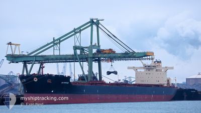
NYMPHE
Bulk Carrier
Current Trip
THERE
| Time Travelled | 14 days |
|---|---|
| Remaining Time | --- |
| Distance Travelled | 3843.65 nm |
| Remaining Distance | --- |
| AVG Speed | 11.3 Knop |
| MAX Speed | 15.8 Knop |
| AVG Wind | 12.7 knots |
| MAX Wind | 33.9 knots |
| MIN Temp | -6.9°C / 19.58°F |
| MAX Temp | 18.8°C / 65.84°F |
| Djupgående | 17.4 m |
| Position mottagen | 1 m sen |
Current Position
| Longitud | 21.62540° |
|---|---|
| Latitude | 36.31410° |
| Status | Under way using engine |
| Fart | 11 Knop |
| Kurs | 87° |
| Område | Mediterranean Sea - Eastern Basin |
| Station | T-AIS |
| Position mottagen | 1 m sen |
Info
Information
The current position of NYMPHE is in Mediterranean Sea - Eastern Basin with coordinates 36.31410° / 21.62540° as reported on 2024-05-01 07:23 by AIS to our vessel tracker app. The vessel's current speed is 11 Knop
The vessel NYMPHE (IMO: 9438781, MMSI: 240929000) is a Bulk Carrier that was built in 2009 ( 15 År gammal ). It's sailing under the flag of [GR] Greece.
In this page you can find informations about the vessels current position, last detected port calls, and current voyage information. If the vessels is not in coverage by AIS you will find the latest position.
The current position of NYMPHE is detected by our AIS receivers and we are not responsible for the reliability of the data. The last position was recorded while the vessel was in Coverage by the Ais receivers of our vessel tracking app.
The current draught of NYMPHE as reported by AIS is 17.4 meters
Weather
| Temperature | 18°C / 64.4°F |
|---|---|
| Wind Speed | 6 knots |
| Direction | 128° SE |
| Pressure | 1015 hPa |
| Humidity | 81.7 % |
| Cloud Coverage | 68 % |
Featured Company
Events
| Tid | Event | Detaljer | Position / Dest | Information |
|---|---|---|---|---|
| 2024-05-01 06:02 | Status ändrad | Under way using engine Default |
36.30762 / 21.31868
THERE
|
Fart: 11.5 kn Kurs: 89° |
| 2024-05-01 06:02 | I täckningsområde |
36.30768 / 21.32247
Mediterranean Sea - Eastern Basin
THERE
|
Fart: 11.2 kn Kurs: 89° |
|
| 2024-05-01 04:02 | Status ändrad | Default Under way using engine |
36.31897 / 20.83912
THERE
|
Fart: 11.6 kn Kurs: 93° |
| 2024-05-01 03:53 | UTANFÖR täckningsområde |
36.31933 / 20.80252
Mediterranean Sea - Eastern Basin
THERE
|
Fart: 11.6 kn Kurs: 93° |
|
| 2024-05-01 03:47 | Status ändrad | Under way using engine Default |
36.31913 / 20.77850
THERE
|
Fart: 11.5 kn Kurs: 88° |
| 2024-05-01 03:39 | Status ändrad | Default Under way using engine |
36.31962 / 20.74406
THERE
|
Fart: 11.5 kn Kurs: 90° |
| 2024-05-01 03:09 | Status ändrad | Under way using engine Default |
36.32002 / 20.62402
THERE
|
Fart: 11.4 kn Kurs: 91° |
| 2024-05-01 02:32 | Status ändrad | Default Under way using engine |
36.32052 / 20.48198
THERE
|
Fart: 11.2 kn Kurs: 89° |
| 2024-05-01 02:03 | Status ändrad | Under way using engine Default |
36.32128 / 20.36860
THERE
|
Fart: 11.3 kn Kurs: 91° |
| 2024-05-01 01:55 | Status ändrad | Default Under way using engine |
36.32117 / 20.33893
THERE
|
Fart: 11.3 kn Kurs: 91° |