

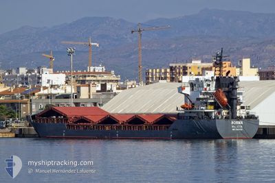
NORMA
General Cargo

Current Trip
| Time Travelled | 10 days |
|---|---|
| Remaining Time | --- |
| Distance Travelled | 1528.09 nm |
| Remaining Distance | --- |
| AVG Speed | 9.5 Knop |
| MAX Speed | 12.4 Knop |
| AVG Wind | 12.7 knots |
| MAX Wind | 26 knots |
| MIN Temp | 2.9°C / 37.22°F |
| MAX Temp | 19.1°C / 66.38°F |
| Djupgående | 6.9 m |
| Position mottagen | 1 d sen |
Current Position
| Longitud | --- |
|---|---|
| Latitude | --- |
| Status | Under way using engine |
| Fart | 9.4 Knop |
| Kurs | 295° |
| Område | Tyrrhenian Sea |
| Station | T-AIS |
| Position mottagen | 1 d sen |
Information
The current position of NORMA is in Tyrrhenian Sea with coordinates 38.42183° / 11.87383° as reported on 2025-03-10 16:35 by AIS to our vessel tracker app. The vessel's current speed is 9.4 Knop and is heading at the port of AVEIRO. The estimated time of arrival as calculated by MyShipTracking vessel tracking app is 2025-03-16 06:00 LT
The vessel NORMA (IMO: 9306419, MMSI: 256161000) is a General Cargo that was built in 2006 ( 19 År gammal ). It's sailing under the flag of [MT] Malta.
In this page you can find informations about the vessels current position, last detected port calls, and current voyage information. If the vessels is not in coverage by AIS you will find the latest position.
The current position of NORMA is detected by our AIS receivers and we are not responsible for the reliability of the data. The last position was recorded while the vessel was in Coverage by the Ais receivers of our vessel tracking app.
The current draught of NORMA as reported by AIS is 6.9 meters
Weather
| Temperature | 17.2°C / 62.96°F |
|---|---|
| Wind Speed | 8 knots |
| Direction | 302° WNW |
| Pressure | 1003.8 hPa |
| Humidity | 66.3 % |
| Cloud Coverage | 90 % |


Featured Company
Last Port Calls
| Port | Arrival | Departure | Time In Port |
|---|---|---|---|
| 2025-02-28 07:08 | 2025-03-02 11:41 | 2 d | |
| 2025-02-18 14:36 | 2025-02-22 10:22 | 3 d | |
| 2025-02-09 09:49 | 2025-02-15 07:26 | 5 d | |
| 2025-02-04 14:29 | 2025-02-05 18:29 | 1 d | |
| 2025-01-27 06:55 | 2025-02-01 08:24 | 5 d | |
| 2025-01-13 05:19 | 2025-01-16 13:49 | 3 d |
Last Trips
| Origin | Departure | Destination | Arrival | Distance | |
|---|---|---|---|---|---|
| 2025-02-22 11:22 | 2025-02-28 10:08 | 1001.46 nm | |||
| 2025-02-15 08:26 | 2025-02-18 15:36 | 714.28 nm | |||
| 2025-02-05 19:29 | 2025-02-09 10:49 | 221.37 nm | |||
| 2025-02-01 09:24 | 2025-02-04 15:29 | 387.93 nm | |||
| 2025-01-16 16:49 | 2025-01-27 07:55 | 1769.18 nm | |||
| 2024-12-31 11:00 | 2025-01-13 08:19 | 428.89 nm |
Events
| Tid | Event | Detaljer | Position / Dest | Information |
|---|---|---|---|---|
| 2025-03-12 09:42 | STOPPAR förflyttning | 5.38 nm, South East of BEJAIA |
36.71700 / 5.19800
PT AVE
|
Fart: 0.3 kn Kurs: 267° |
| 2025-03-12 07:37 | STARTAR förflyttning | 8.71 nm, North of ZIAMA MANSOURIA |
36.81467 / 5.42117
PT AVE
|
Fart: 3.8 kn Kurs: 240° |
| 2025-03-12 05:50 | STOPPAR förflyttning | 9.19 nm, North West of ZIAMA MANSOURIA |
36.81238 / 5.38987
PT AVE
|
Fart: 0.3 kn Kurs: 279° |
| 2025-03-10 16:38 | Status ändrad | Default Under way using engine |
38.42533 / 11.86350
PT AVE
|
Fart: 9.4 kn Kurs: 295° |
| 2025-03-10 16:35 | UTANFÖR täckningsområde |
38.42183 / 11.87383
Tyrrhenian Sea
PT AVE
|
Fart: 9.4 kn Kurs: 295° |
|
| 2025-03-10 12:28 | Status ändrad | Under way using engine Default |
38.32417 / 12.64817
PT AVE
|
Fart: 9.7 kn Kurs: 269° |
| 2025-03-10 12:08 | Status ändrad | Default Under way using engine |
38.32533 / 12.71700
PT AVE
|
Fart: 9.6 kn Kurs: 270° |
| 2025-03-10 11:59 | Status ändrad | Under way using engine Default |
38.32600 / 12.74767
PT AVE
|
Fart: 9.6 kn Kurs: 272° |
| 2025-03-10 11:43 | Status ändrad | Default Under way using engine |
38.32567 / 12.80150
PT AVE
|
Fart: 9.6 kn Kurs: 272° |
| 2025-03-10 06:12 | STARTAR förflyttning | 2.65 nm, North of TERMINI IMERESE |
38.02600 / 13.73717
PT AVE
|
Fart: 3.1 kn Kurs: 327° |