
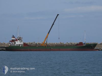
NORDBERG
Cargo
Current Trip
| Time Travelled | 17 h, 36 mins |
|---|---|
| Remaining Time | --- |
| Distance Travelled | 164.03 nm |
| Remaining Distance | --- |
| AVG Speed | 9.1 Knop |
| MAX Speed | 10.4 Knop |
| AVG Wind | 16.7 knots |
| MAX Wind | 22.2 knots |
| MIN Temp | 15.6°C / 60.08°F |
| MAX Temp | 20°C / 68°F |
| Djupgående | 5.2 m |
| Position mottagen | 1 m sen |
Current Position
| Longitud | 25.73957° |
|---|---|
| Latitude | 36.53338° |
| Status | Under way using engine |
| Fart | 10.3 Knop |
| Kurs | 279.8° |
| Område | Aegean Sea |
| Station | T-AIS |
| Position mottagen | 1 m sen |
Info
Information
The current position of NORDBERG is in Aegean Sea with coordinates 36.53338° / 25.73957° as reported on 2024-05-05 01:49 by AIS to our vessel tracker app. The vessel's current speed is 10.3 Knop and is heading at the port of AGIOS NIKOLAOS. The estimated time of arrival as calculated by MyShipTracking vessel tracking app is 2024-05-06 04:00 LT
The vessel NORDBERG (IMO: 8952467, MMSI: 511100562) is a Cargo It's sailing under the flag of [PW] Palau.
In this page you can find informations about the vessels current position, last detected port calls, and current voyage information. If the vessels is not in coverage by AIS you will find the latest position.
The current position of NORDBERG is detected by our AIS receivers and we are not responsible for the reliability of the data. The last position was recorded while the vessel was in Coverage by the Ais receivers of our vessel tracking app.
The current draught of NORDBERG as reported by AIS is 5.2 meters
Weather
| Temperature | 16.6°C / 61.88°F |
|---|---|
| Wind Speed | 21 knots |
| Direction | 322° NW |
| Pressure | 1007.6 hPa |
| Humidity | 75.9 % |
| Cloud Coverage | 99 % |
Featured Company
Last Port Calls
| Port | Arrival | Departure | Time In Port |
|---|---|---|---|
| 2024-05-01 21:09 | 2024-05-04 08:14 | 2 d | |
| 2024-04-30 12:08 | |||
| 2024-04-23 06:12 | 2024-04-26 18:44 | 3 d | |
| 2024-04-18 04:24 | 2024-04-22 15:03 | 4 d | |
| 2024-04-14 08:19 | 2024-04-14 21:36 | 13 h | |
| 2024-04-09 22:43 | 2024-04-12 21:26 | 2 d | |
| 2024-04-05 01:25 | 2024-04-05 13:17 | 11 h | |
| 2024-03-20 09:35 | 2024-03-20 19:28 | 9 h | |
| 2024-03-14 14:15 | 2024-03-15 17:57 | 1 d |
Most Visited Ports (Last year)
| Port | Arrivals | |
|---|---|---|
| 4 | ||
| 2 | ||
| 2 | ||
| 2 | ||
| 2 | ||
| 2 |
Last Trips
| Origin | Departure | Destination | Arrival | Distance | |
|---|---|---|---|---|---|
| 2024-04-30 15:08 | 2024-05-02 00:09 | 242.32 nm | |||
| 2024-04-22 17:03 | 2024-04-23 08:12 | 45.22 nm | |||
| 2024-04-15 00:36 | 2024-04-18 06:24 | 706.82 nm | |||
| 2024-04-12 23:26 | 2024-04-14 11:19 | 335.88 nm | |||
| 2024-04-05 15:17 | 2024-04-10 00:43 | 14.69 nm | |||
| 2024-03-20 20:28 | 2024-04-05 03:25 | 2769.59 nm | |||
| 2024-03-15 17:57 | 2024-03-20 10:35 | 461.01 nm | |||
| 2024-02-19 00:12 | 2024-03-14 14:15 | 2537.62 nm |
Events
| Tid | Event | Detaljer | Position / Dest | Information |
|---|---|---|---|---|
| 2024-05-04 20:34 | I täckningsområde |
36.52203 / 26.79920
Aegean Sea
GR STN
|
Fart: 9.4 kn Kurs: 260° |
|
| 2024-05-04 18:12 | UTANFÖR täckningsområde |
36.53086 / 27.25982
Aegean Sea
GR STN
|
Fart: 9.4 kn Kurs: 266.1° |
|
| 2024-05-04 14:38 | Byter havsområde | Greek part of the Aegean Sea Turkish part of the Aegean Sea |
36.48472 / 27.94939
Aegean Sea
GR STN
|
Fart: 9.3 kn Kurs: 261° |
| 2024-05-04 14:08 | Byter havsområde | Turkish part of the Aegean Sea Greek part of the Aegean Sea |
36.49498 / 28.04620
Aegean Sea
GR STN
|
Fart: 9.3 kn Kurs: 262.5° |
| 2024-05-04 13:49 | Status ändrad | Under way using engine Default |
36.50224 / 28.10571
GR STN
|
Fart: 8.7 kn Kurs: 258° |
| 2024-05-04 13:34 | Status ändrad | Default Under way using engine |
36.50789 / 28.15162
GR STN
|
Fart: 8.5 kn Kurs: 257.6° |
| 2024-05-04 13:08 | Byter havsområde | Greek part of the Aegean Sea Greek part of the Mediterranean Sea - Eastern Basin |
36.51710 / 28.22321
Aegean Sea
GR STN
|
Fart: 7.9 kn Kurs: 278.4° |
| 2024-05-04 11:50 | Byter havsområde | Greek part of the Mediterranean Sea - Eastern Basin Turkish part of the Mediterranean Sea - Eastern Basin |
36.55118 / 28.44583
Mediterranean Sea - Eastern Basin
GR STN
|
Fart: 8.5 kn Kurs: 268.6° |
| 2024-05-04 08:18 | Destination ändrad | GR STN TRFET |
36.64894 / 29.07980
GR STN
|
Fart: 7.4 kn Kurs: 262.6° |
| 2024-05-04 08:18 | ETA ändrat | 2024/05/06 04:00 2024/05/02 00:30 |
36.64894 / 29.07980
GR STN
|
Fart: 7.4 kn Kurs: 262.6° |