
NAVIGARE TERRA MATER
Tanker
Current Trip
| Time Travelled | 5 days |
|---|---|
| Remaining Time | --- |
| Distance Travelled | 1330.60 nm |
| Remaining Distance | --- |
| AVG Speed | 10.5 Knop |
| MAX Speed | 14.4 Knop |
| AVG Wind | 16.3 knots |
| MAX Wind | 33.6 knots |
| MIN Temp | 7.8°C / 46.04°F |
| MAX Temp | 13.8°C / 56.84°F |
| Djupgående | 11.8 m |
| Position mottagen | 3 d sen |
Current Position
| Longitud | -6.19866° |
|---|---|
| Latitude | 49.51474° |
| Status | Under way using engine |
| Fart | 8.8 Knop |
| Kurs | 275.2° |
| Område | Celtic Sea |
| Station | T-AIS |
| Position mottagen | 3 d sen |
Info
Information
The current position of NAVIGARE TERRA MATER is in Celtic Sea with coordinates 49.51474° / -6.19866° as reported on 2024-04-28 18:13 by AIS to our vessel tracker app. The vessel's current speed is 8.8 Knop and is heading at the port of CORPUS CHRISTI. The estimated time of arrival as calculated by MyShipTracking vessel tracking app is 2024-05-18 22:00 LT
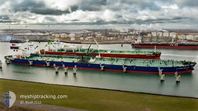
The vessel NAVIGARE TERRA MATER (IMO: 9740330, MMSI: 219029122) is a Tanker It's sailing under the flag of [DK] Denmark.
In this page you can find informations about the vessels current position, last detected port calls, and current voyage information. If the vessels is not in coverage by AIS you will find the latest position.
The current position of NAVIGARE TERRA MATER is detected by our AIS receivers and we are not responsible for the reliability of the data. The last position was recorded while the vessel was in Coverage by the Ais receivers of our vessel tracking app.
The current draught of NAVIGARE TERRA MATER as reported by AIS is 11.8 meters
Weather
| Temperature | 13.8°C / 56.84°F |
|---|---|
| Wind Speed | 14 knots |
| Direction | 121° ESE |
| Pressure | 1016 hPa |
| Humidity | 86 % |
| Cloud Coverage | 99 % |
Featured Company
Most Visited Ports (Last year)
| Port | Arrivals | |
|---|---|---|
| 2 | ||
| 1 | ||
| 1 | ||
| 1 | ||
| 1 | ||
| 1 |
Events
| Tid | Event | Detaljer | Position / Dest | Information |
|---|---|---|---|---|
| 2024-04-28 18:18 | Status ändrad | Default Under way using engine |
49.51379 / -6.21570
US CRP
|
Fart: 8.8 kn Kurs: 275.2° |
| 2024-04-28 18:13 | UTANFÖR täckningsområde |
49.51474 / -6.19866
Celtic Sea
US CRP
|
Fart: 8.8 kn Kurs: 275.2° |
|
| 2024-04-28 18:05 | Status ändrad | Under way using engine Default |
49.51288 / -6.16600
US CRP
|
Fart: 8.7 kn Kurs: 271° |
| 2024-04-28 17:54 | Status ändrad | Default Under way using engine |
49.51418 / -6.12713
US CRP
|
Fart: 8.7 kn Kurs: 247.3° |
| 2024-04-28 17:48 | Upptäckt i hav | United Kingdom part of the Celtic Sea |
49.51774 / -6.10438
Celtic Sea
US CRP
|
Fart: 8.7 kn Kurs: 247.3° |
| 2024-04-28 17:47 | Status ändrad | Under way using engine Default |
49.51835 / -6.10212
US CRP
|
Fart: 8.8 kn Kurs: 249° |
| 2024-04-28 17:42 | I täckningsområde |
49.51774 / -6.10438
Celtic Sea
US CRP
|
Fart: 8.7 kn Kurs: 247.3° |
|
| 2024-04-28 12:43 | Status ändrad | Default Under way using engine |
49.76162 / -4.87405
US CRP
|
Fart: 10.2 kn Kurs: 259.7° |
| 2024-04-28 12:35 | Status ändrad | Under way using engine Default |
49.76557 / -4.84136
US CRP
|
Fart: 10.2 kn Kurs: 259° |
| 2024-04-28 12:35 | UTANFÖR täckningsområde |
49.76557 / -4.84136
English Channel
US CRP
|
Fart: 10.2 kn Kurs: 259.7° |