
NAVAL AUXILIARY 203
Replenishment Vessel
Current Trip
| Trip Time | --- |
|---|---|
| Trip Distance | --- |
| AVG Speed | --- |
| MAX Speed | --- |
| Djupgående | --- |
| AVG Wind | --- |
| MAX Wind | --- |
| MIN Temp | --- |
| MAX Temp | --- |
| Position mottagen | 1 d sen |
Current Position
| Longitud | --- |
|---|---|
| Latitude | --- |
| Status | Moored |
| Fart | |
| Kurs | 317° |
| Område | Aegean Sea |
| Station | T-AIS |
| Position mottagen | 1 d sen |
Information
The current position of NAVAL AUXILIARY 203 is in Aegean Sea with coordinates 35.50498° / 24.10966° as reported on 2025-03-11 07:30 by AIS to our vessel tracker app. The vessel's current speed is 0 Knop and is currently inside the port of SOUDA.
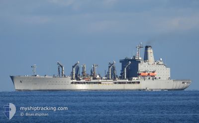
The vessel NAVAL AUXILIARY 203 (IMO: 8906626, MMSI: 367861000) is a Replenishment Vessel that was built in 1998 ( 27 År gammal ). It's sailing under the flag of [US] USA.
In this page you can find informations about the vessels current position, last detected port calls, and current voyage information. If the vessels is not in coverage by AIS you will find the latest position.
The current position of NAVAL AUXILIARY 203 is detected by our AIS receivers and we are not responsible for the reliability of the data. The last position was recorded while the vessel was in Coverage by the Ais receivers of our vessel tracking app.
The current draught of NAVAL AUXILIARY 203 as reported by AIS is 10.2 meters
Weather
| Temperature | 16.9°C / 62.42°F |
|---|---|
| Wind Speed | 1 knots |
| Direction | 180° S |
| Pressure | 1018.4 hPa |
| Humidity | 49.5 % |
| Cloud Coverage | 21 % |
Featured Company
Events
| Tid | Event | Detaljer | Position / Dest | Information |
|---|---|---|---|---|
| 2025-03-11 07:33 | Status ändrad | Default Moored |
35.50502 / 24.10961
[GR] SOUDA
|
Fart: Kurs: 317° |
| 2025-03-11 07:30 | UTANFÖR täckningsområde |
35.50498 / 24.10966
Aegean Sea
[GR] SOUDA
|
Fart: Kurs: 59.1° |
|
| 2025-03-10 07:15 | STOPPAR förflyttning |
35.50495 / 24.10958
[GR] SOUDA
|
Fart: 0.3 kn Kurs: 314° |
|
| 2025-03-10 06:36 | ANLÄNDER HAMN |
|
35.49495 / 24.11928
[GR] SOUDA
|
Fart: 2.1 kn Kurs: 296° |
| 2025-03-10 06:22 | STARTAR förflyttning | 2.15 nm, South West of MARATHI |
35.49037 / 24.13297
1
|
Fart: 3.4 kn Kurs: 289° |
| 2025-03-10 05:16 | I täckningsområde |
35.49628 / 24.14723
Aegean Sea
|
Fart: Kurs: 6.4° |
|
| 2025-03-09 06:51 | UTANFÖR täckningsområde |
35.49630 / 24.14722
Aegean Sea
|
Fart: Kurs: 6.4° |
|
| 2025-03-09 06:40 | STOPPAR förflyttning | 1.37 nm, West of MARATHI |
35.49614 / 24.14728
1
|
Fart: 0.2 kn Kurs: 86° |
| 2025-03-09 05:09 | I täckningsområde |
35.58987 / 24.26726
Aegean Sea
|
Fart: 9.2 kn Kurs: 215.2° |