
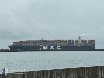
MSC BEATRICE
Container Ship
Current Trip
VUNG TAO
| Time Travelled | 25 days |
|---|---|
| Remaining Time | --- |
| Distance Travelled | 8200.76 nm |
| Remaining Distance | --- |
| AVG Speed | 11.2 Knop |
| MAX Speed | 21 Knop |
| AVG Wind | 19.7 knots |
| MAX Wind | 40 knots |
| MIN Temp | 5.8°C / 42.44°F |
| MAX Temp | 28.3°C / 82.94°F |
| Djupgående | 11.6 m |
| Position mottagen | 2 d sen |
Current Position
| Longitud | --- |
|---|---|
| Latitude | --- |
| Status | Under way using engine |
| Fart | 17.5 Knop |
| Kurs | 114.2° |
| Område | South Atlantic Ocean |
| Station | T-AIS |
| Position mottagen | 2 d sen |
Info
Information
The current position of MSC BEATRICE is in South Atlantic Ocean with coordinates -34.81916° / 19.39578° as reported on 2025-02-15 16:06 by AIS to our vessel tracker app. The vessel's current speed is 17.5 Knop
The vessel MSC BEATRICE (IMO: 9399014, MMSI: 353162000) is a Container Ship that was built in 2009 ( 16 År gammal ). It's sailing under the flag of [PA] Panama.
In this page you can find informations about the vessels current position, last detected port calls, and current voyage information. If the vessels is not in coverage by AIS you will find the latest position.
The current position of MSC BEATRICE is detected by our AIS receivers and we are not responsible for the reliability of the data. The last position was recorded while the vessel was in Coverage by the Ais receivers of our vessel tracking app.
The current draught of MSC BEATRICE as reported by AIS is 11.6 meters
Weather
| Temperature | 25.9°C / 78.62°F |
|---|---|
| Wind Speed | 12 knots |
| Direction | 67° ENE |
| Pressure | 1014.4 hPa |
| Humidity | 78.7 % |
| Cloud Coverage | 98 % |
Featured Company
Last Port Calls
| Port | Arrival | Departure | Time In Port |
|---|---|---|---|
| 2025-01-20 17:49 | 2025-01-23 12:24 | 2 d | |
| 2024-12-02 06:46 | 2024-12-03 10:03 | 1 d |
Most Visited Ports (Last year)
| Port | Arrivals | |
|---|---|---|
| 4 | ||
| 2 | ||
| 2 | ||
| 2 | ||
| 2 | ||
| 2 |
Last Trips
| Origin | Departure | Destination | Arrival | Distance | |
|---|---|---|---|---|---|
| 2024-12-03 10:03 | 2025-01-20 17:49 | 12194.10 nm | |||
| 2024-11-28 11:28 | 2024-12-02 06:46 | 1499.75 nm |
Events
| Tid | Event | Detaljer | Position / Dest | Information |
|---|---|---|---|---|
| 2025-02-15 16:11 | Status ändrad | Default Under way using engine |
-34.83066 / 19.42525
VUNG TAO
|
Fart: 17.5 kn Kurs: 114.2° |
| 2025-02-15 16:06 | Status ändrad | Under way using engine Default |
-34.81916 / 19.39578
VUNG TAO
|
Fart: 17.3 kn Kurs: 110° |
| 2025-02-15 16:06 | UTANFÖR täckningsområde |
-34.81916 / 19.39578
South Atlantic Ocean
VUNG TAO
|
Fart: 17.5 kn Kurs: 114.2° |
|
| 2025-02-15 15:20 | Status ändrad | Default Under way using engine |
-34.73175 / 19.14800
VUNG TAO
|
Fart: 17.2 kn Kurs: 115.4° |
| 2025-02-15 15:01 | Status ändrad | Under way using engine Default |
-34.69316 / 19.04977
VUNG TAO
|
Fart: 17.2 kn Kurs: 115° |
| 2025-02-15 14:52 | Status ändrad | Default Under way using engine |
-34.67475 / 19.00156
VUNG TAO
|
Fart: 17.1 kn Kurs: 114.8° |
| 2025-02-15 14:45 | Status ändrad | Under way using engine Default |
-34.66036 / 18.96453
VUNG TAO
|
Fart: 17.1 kn Kurs: 114° |
| 2025-02-15 14:16 | Status ändrad | Default Under way using engine |
-34.60171 / 18.81321
VUNG TAO
|
Fart: 17 kn Kurs: 114.5° |
| 2025-02-15 14:09 | Status ändrad | Under way using engine Default |
-34.58839 / 18.77938
VUNG TAO
|
Fart: 16.9 kn Kurs: 115° |
| 2025-02-15 14:08 | Status ändrad | Default Under way using engine |
-34.58620 / 18.77371
VUNG TAO
|
Fart: 16.9 kn Kurs: 116.8° |