
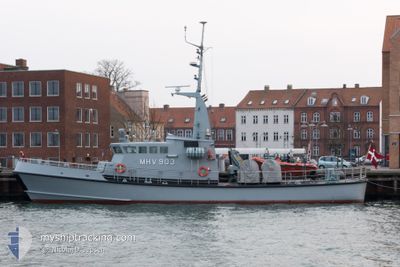
MHV 903 HJORTOE
Military ops
Current Trip
ROENNE
| Time Travelled | 3 h, 9 mins |
|---|---|
| Remaining Time | --- |
| Distance Travelled | 29.39 nm |
| Remaining Distance | --- |
| AVG Speed | 8 Knop |
| MAX Speed | 10.5 Knop |
| AVG Wind | 13.8 knots |
| MAX Wind | 17.2 knots |
| MIN Temp | 3.1°C / 37.58°F |
| MAX Temp | 4°C / 39.2°F |
| Djupgående | 2.5 m |
| Position mottagen | Nu |
Current Position
| Longitud | --- |
|---|---|
| Latitude | --- |
| Status | Under way using engine |
| Fart | 10.1 Knop |
| Kurs | 91.6° |
| Område | Baltic Sea |
| Station | T-AIS |
| Position mottagen | Nu |
Info
Information
The current position of MHV 903 HJORTOE is in Baltic Sea with coordinates 54.92521° / 12.81540° as reported on 2025-03-02 01:17 by AIS to our vessel tracker app. The vessel's current speed is 10.1 Knop
The vessel MHV 903 HJORTOE (MMSI: 219000167) is a Military ops It's sailing under the flag of [DK] Denmark.
In this page you can find informations about the vessels current position, last detected port calls, and current voyage information. If the vessels is not in coverage by AIS you will find the latest position.
The current position of MHV 903 HJORTOE is detected by our AIS receivers and we are not responsible for the reliability of the data. The last position was recorded while the vessel was in Coverage by the Ais receivers of our vessel tracking app.
The current draught of MHV 903 HJORTOE as reported by AIS is 2.5 meters
Weather
| Temperature | 3.4°C / 38.12°F |
|---|---|
| Wind Speed | 17 knots |
| Direction | 274° W |
| Pressure | 1029.6 hPa |
| Humidity | 87.4 % |
| Cloud Coverage | 100 % |
Featured Company
Last Port Calls
| Port | Arrival | Departure | Time In Port |
|---|---|---|---|
| 2025-03-01 19:45 | 2025-03-01 22:08 | 2 h | |
| 2025-03-01 01:33 | 2025-03-01 10:12 | 8 h | |
| 2025-02-20 14:07 | 2025-02-28 19:17 | 8 d | |
| 2025-02-10 14:49 | 2025-02-20 13:38 | 9 d | |
| 2025-01-23 12:59 | 2025-02-10 14:11 | 18 d | |
| 2025-01-13 05:06 | 2025-01-23 11:12 | 10 d | |
| 2025-01-12 23:38 | 2025-01-13 04:26 | 4 h | |
| 2025-01-12 20:41 | 2025-01-12 23:37 | 2 h | |
| 2025-01-12 17:06 | 2025-01-12 20:32 | 3 h | |
| 2025-01-12 07:06 | 2025-01-12 16:50 | 9 h |
Last Trips
| Origin | Departure | Destination | Arrival | Distance | |
|---|---|---|---|---|---|
| 2025-03-01 11:12 | 2025-03-01 20:45 | 118.41 nm | |||
| 2025-02-28 20:17 | 2025-03-01 02:33 | 71.71 nm | |||
| 2025-02-20 14:38 | 2025-02-20 15:07 | 4.50 nm | |||
| 2025-02-10 15:11 | 2025-02-10 15:49 | 7.61 nm | |||
| 2025-01-23 12:12 | 2025-01-23 13:59 | 15.23 nm | |||
| 2025-01-13 05:26 | 2025-01-13 06:06 | 17.02 nm | |||
| 2025-01-13 00:37 | 2025-01-13 00:38 | 0.69 nm | |||
| 2025-01-12 21:32 | 2025-01-12 21:41 | 0.83 nm | |||
| 2025-01-12 17:50 | 2025-01-12 18:06 | 0.33 nm | |||
| 2025-01-12 07:59 | 2025-01-12 08:06 | 0.33 nm |
Events
| Tid | Event | Detaljer | Position / Dest | Information |
|---|---|---|---|---|
| 2025-03-01 22:58 | Byter havsområde | Danish part of the Baltic Sea Danish part of the Kattegat |
54.84017 / 12.17498
Baltic Sea
|
Fart: 8.7 kn Kurs: 143.5° |
| 2025-03-01 22:21 | Status ändrad | Under way using engine Moored |
54.89559 / 12.08685
ROENNE
|
Fart: 8.4 kn Kurs: 108.6° |
| 2025-03-01 22:08 | STARTAR förflyttning | 0.15 nm, North of STUBBEKOBING |
54.89548 / 12.04485
ROENNE
|
Fart: 8.4 kn Kurs: 6.5° |
| 2025-03-01 22:08 | AVGÅTT HAMN |
|
54.89439 / 12.04472
ROENNE
|
Fart: 6.9 kn Kurs: 1° |
| 2025-03-01 19:49 | Status ändrad | Moored Under way using engine |
54.89266 / 12.04500
[DK] STUBBEKOBING
|
Fart: 0.1 kn Kurs: 100° |
| 2025-03-01 19:45 | ANLÄNDER HAMN |
|
54.89281 / 12.04501
[DK] STUBBEKOBING
|
Fart: 0.9 kn Kurs: 206° |
| 2025-03-01 19:43 | STOPPAR förflyttning | 0.08 nm, North East of STUBBEKOBING |
54.89369 / 12.04576
ROENNE
|
Fart: 0.2 kn Kurs: 189° |
| 2025-03-01 10:12 | AVGÅTT HAMN |
|
56.41857 / 10.94099
ROENNE
|
Fart: 13.3 kn Kurs: 57° |
| 2025-03-01 10:08 | STARTAR förflyttning |
56.41051 / 10.92774
[DK] GRENAA
|
Fart: 5.4 kn Kurs: 38° |
|
| 2025-03-01 10:00 | Status ändrad | Under way using engine Moored |
56.40976 / 10.92466
[DK] GRENAA
|
Fart: Kurs: 81° |