
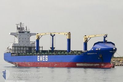
MARGUERITE A
Container Ship
Current Trip
| Time Travelled | 2 days |
|---|---|
| Remaining Time | --- |
| Distance Travelled | 937.59 nm |
| Remaining Distance | --- |
| AVG Speed | 15.1 Knop |
| MAX Speed | 16.2 Knop |
| AVG Wind | 10.9 knots |
| MAX Wind | 23 knots |
| MIN Temp | 13.2°C / 55.76°F |
| MAX Temp | 18.8°C / 65.84°F |
| Djupgående | 8.8 m |
| Position mottagen | 1 h, 21 m sen |
Current Position
| Longitud | 23.70297° |
|---|---|
| Latitude | 36.92278° |
| Status | Under way using engine |
| Fart | 15.5 Knop |
| Kurs | 43.8° |
| Område | Aegean Sea |
| Station | T-AIS |
| Position mottagen | 1 h, 21 m sen |
Info
Information
The current position of MARGUERITE A is in Aegean Sea with coordinates 36.92278° / 23.70297° as reported on 2024-05-05 21:35 by AIS to our vessel tracker app. The vessel's current speed is 15.5 Knop and is heading at the port of GEMLIK. The estimated time of arrival as calculated by MyShipTracking vessel tracking app is 2024-05-06 22:00 LT
The vessel MARGUERITE A (IMO: 9305893, MMSI: 215416000) is a Container Ship that was built in 2005 ( 19 År gammal ). It's sailing under the flag of [MT] Malta.
In this page you can find informations about the vessels current position, last detected port calls, and current voyage information. If the vessels is not in coverage by AIS you will find the latest position.
The current position of MARGUERITE A is detected by our AIS receivers and we are not responsible for the reliability of the data. The last position was recorded while the vessel was in Coverage by the Ais receivers of our vessel tracking app.
The current draught of MARGUERITE A as reported by AIS is 8.8 meters
Weather
| Temperature | 17.9°C / 64.22°F |
|---|---|
| Wind Speed | 13 knots |
| Direction | 15° NNE |
| Pressure | 1016.8 hPa |
| Humidity | 66.8 % |
| Cloud Coverage | --- |
Featured Company
Last Port Calls
| Port | Arrival | Departure | Time In Port |
|---|---|---|---|
| 2024-05-02 03:16 | 2024-05-03 08:56 | 1 d | |
| 2024-04-30 03:03 | 2024-05-01 11:01 | 1 d | |
| 2024-04-28 07:01 | 2024-04-29 04:22 | 21 h | |
| 2024-04-25 16:20 | 2024-04-26 03:26 | 11 h | |
| 2024-04-22 16:43 | 2024-04-23 07:32 | 14 h | |
| 2024-04-21 21:11 | 2024-04-22 09:21 | 12 h | |
| 2024-04-20 23:00 | 2024-04-21 16:36 | 17 h | |
| 2024-04-15 14:48 | 2024-04-16 20:23 | 1 d | |
| 2024-04-14 07:29 | 2024-04-15 11:19 | 1 d | |
| 2024-04-11 16:40 | 2024-04-12 16:58 | 1 d |
Last Trips
| Origin | Departure | Destination | Arrival | Distance | |
|---|---|---|---|---|---|
| 2024-05-01 13:01 | 2024-05-02 05:16 | 70.09 nm | |||
| 2024-04-29 06:22 | 2024-04-30 05:03 | 368.70 nm | |||
| 2024-04-26 06:26 | 2024-04-28 09:01 | 800.46 nm | |||
| 2024-04-23 10:32 | 2024-04-25 19:20 | 273.98 nm | |||
| 2024-04-22 12:21 | 2024-04-22 19:43 | 57.51 nm | |||
| 2024-04-21 19:36 | 2024-04-22 00:11 | 60.26 nm | |||
| 2024-04-16 22:23 | 2024-04-21 02:00 | 1319.40 nm | |||
| 2024-04-15 13:19 | 2024-04-15 16:48 | 51.69 nm | |||
| 2024-04-12 18:58 | 2024-04-14 09:29 | 373.84 nm | |||
| 2024-04-09 16:05 | 2024-04-11 18:40 | 798.86 nm |
Events
| Tid | Event | Detaljer | Position / Dest | Information |
|---|---|---|---|---|
| 2024-05-05 21:41 | Status ändrad | Default Under way using engine |
36.94282 / 23.72137
TRGEM
|
Fart: 15.5 kn Kurs: 43.8° |
| 2024-05-05 21:35 | UTANFÖR täckningsområde |
36.92278 / 23.70297
Aegean Sea
TRGEM
|
Fart: 15.5 kn Kurs: 43.8° |
|
| 2024-05-05 21:17 | Status ändrad | Under way using engine Default |
36.86551 / 23.63381
TRGEM
|
Fart: 15.4 kn Kurs: 34° |
| 2024-05-05 20:30 | Status ändrad | Default Under way using engine |
36.70471 / 23.48449
TRGEM
|
Fart: 15.5 kn Kurs: 32.8° |
| 2024-05-05 20:22 | Status ändrad | Under way using engine Default |
36.67435 / 23.46031
TRGEM
|
Fart: 15.4 kn Kurs: 32° |
| 2024-05-05 20:16 | Status ändrad | Default Under way using engine |
36.65180 / 23.44244
TRGEM
|
Fart: 15.6 kn Kurs: 32° |
| 2024-05-05 19:05 | Byter havsområde | Greek part of the Aegean Sea Italian part of the Ionian Sea |
36.40632 / 23.22302
Aegean Sea
TRGEM
|
Fart: 14.9 kn Kurs: 68.4° |
| 2024-05-05 19:05 | Status ändrad | Under way using engine Default |
36.40632 / 23.22302
TRGEM
|
Fart: 14.6 kn Kurs: 67° |
| 2024-05-05 18:53 | I täckningsområde |
36.40632 / 23.22302
Aegean Sea
TRGEM
|
Fart: 14.9 kn Kurs: 68.4° |
|
| 2024-05-04 19:52 | UTANFÖR täckningsområde |
37.78658 / 16.02088
Ionian Sea
TRGEM
|
Fart: 15.6 kn Kurs: 107.7° |