

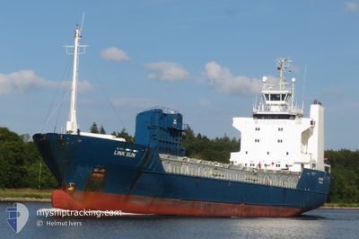
LINK SUN
Ro-Ro Cargo

Current Trip
| Time Travelled | 2 days |
|---|---|
| Remaining Time | --- |
| Distance Travelled | 532.28 nm |
| Remaining Distance | --- |
| AVG Speed | 10.5 Knop |
| MAX Speed | 13.9 Knop |
| AVG Wind | 16.9 knots |
| MAX Wind | 39 knots |
| MIN Temp | 1.3°C / 34.34°F |
| MAX Temp | 8.9°C / 48.02°F |
| Djupgående | 4.7 m |
| Position mottagen | 3 m sen |
Current Position
| Longitud | --- |
|---|---|
| Latitude | --- |
| Status | Moored |
| Fart | |
| Kurs | 177° |
| Område | Inner Seas off the West Coast of Scotland |
| Station | T-AIS |
| Position mottagen | 3 m sen |
Information
The current position of LINK SUN is in Inner Seas off the West Coast of Scotland with coordinates 57.27464° / -5.75296° as reported on 2025-03-26 23:09 by AIS to our vessel tracker app. The vessel's current speed is 0 Knop
The vessel LINK SUN (IMO: 8805597, MMSI: 257969000) is a Ro-Ro Cargo that was built in 1988 ( 37 År gammal ). It's sailing under the flag of [NO] Norway.
In this page you can find informations about the vessels current position, last detected port calls, and current voyage information. If the vessels is not in coverage by AIS you will find the latest position.
The current position of LINK SUN is detected by our AIS receivers and we are not responsible for the reliability of the data. The last position was recorded while the vessel was in Coverage by the Ais receivers of our vessel tracking app.
The current draught of LINK SUN as reported by AIS is 4.7 meters
Weather
| Temperature | 8.7°C / 47.66°F |
|---|---|
| Wind Speed | 13 knots |
| Direction | 210° SSW |
| Pressure | 1014 hPa |
| Humidity | 97.9 % |
| Cloud Coverage | 100 % |


Featured Company
Last Port Calls
| Port | Arrival | Departure | Time In Port |
|---|---|---|---|
| 2025-03-24 07:59 | 2025-03-24 11:21 | 3 h | |
| 2025-03-20 14:57 | 2025-03-21 18:12 | 1 d | |
| 2025-03-17 22:03 | 2025-03-18 01:35 | 3 h | |
| 2025-03-17 12:11 | 2025-03-17 13:48 | 1 h | |
| 2025-03-16 12:02 | 2025-03-16 15:32 | 3 h | |
| 2025-03-15 07:03 | 2025-03-15 20:06 | 13 h | |
| 2025-03-14 09:55 | 2025-03-14 12:00 | 2 h | |
| 2025-03-13 17:09 | 2025-03-14 07:17 | 14 h | |
| 2025-03-13 10:14 | 2025-03-13 14:12 | 3 h | |
| 2025-03-11 18:59 | 2025-03-12 07:30 | 12 h |
Last Trips
| Origin | Departure | Destination | Arrival | Distance | |
|---|---|---|---|---|---|
| 2025-03-21 18:12 | 2025-03-24 07:59 | 706.23 nm | |||
| 2025-03-18 01:35 | 2025-03-20 14:57 | 636.40 nm | |||
| 2025-03-17 13:48 | 2025-03-17 22:03 | 102.60 nm | |||
| 2025-03-16 15:32 | 2025-03-17 12:11 | 169.20 nm | |||
| 2025-03-15 20:06 | 2025-03-16 12:02 | 190.01 nm | |||
| 2025-03-14 12:00 | 2025-03-15 07:03 | 163.80 nm | |||
| 2025-03-14 07:17 | 2025-03-14 09:55 | 29.31 nm | |||
| 2025-03-13 14:12 | 2025-03-13 17:09 | 36.83 nm | |||
| 2025-03-12 07:30 | 2025-03-13 10:14 | 305.97 nm | |||
| 2025-03-10 16:57 | 2025-03-11 18:59 | 271.15 nm |
Events
| Tid | Event | Detaljer | Position / Dest | Information |
|---|---|---|---|---|
| 2025-03-26 21:36 | Status ändrad | Moored Default |
57.27461 / -5.75296
KYLEAKIN
|
Fart: Kurs: 177° |
| 2025-03-26 21:36 | Status ändrad | Default Moored |
57.27461 / -5.75296
KYLEAKIN
|
Fart: Kurs: 177° |
| 2025-03-26 21:29 | Status ändrad | Moored Default |
57.27461 / -5.75290
KYLEAKIN
|
Fart: Kurs: 177° |
| 2025-03-26 21:24 | Status ändrad | Default Moored |
57.27463 / -5.75295
KYLEAKIN
|
Fart: Kurs: 177° |
| 2025-03-26 21:17 | Status ändrad | Moored Default |
57.27463 / -5.75294
KYLEAKIN
|
Fart: Kurs: 177° |
| 2025-03-26 21:11 | Status ändrad | Default Moored |
57.27461 / -5.75294
KYLEAKIN
|
Fart: Kurs: 177° |
| 2025-03-26 19:21 | Status ändrad | Moored Default |
57.27464 / -5.75293
KYLEAKIN
|
Fart: Kurs: 177° |
| 2025-03-26 19:17 | Status ändrad | Default Moored |
57.27463 / -5.75294
KYLEAKIN
|
Fart: Kurs: 177° |
| 2025-03-26 19:11 | Status ändrad | Moored Default |
57.27466 / -5.75297
KYLEAKIN
|
Fart: Kurs: 177° |
| 2025-03-26 19:03 | Status ändrad | Default Moored |
57.27464 / -5.75296
KYLEAKIN
|
Fart: Kurs: 177° |