
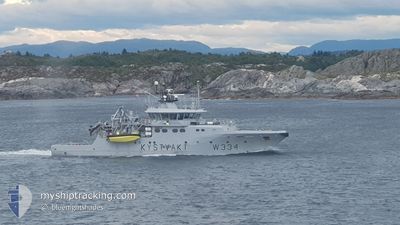
KV TOR
Patrol Vessel
Current Trip
COASTGUARD PATROL
| Time Travelled | 23 h, 27 mins |
|---|---|
| Remaining Time | --- |
| Distance Travelled | 88.40 nm |
| Remaining Distance | --- |
| AVG Speed | 10.2 Knop |
| MAX Speed | 12.6 Knop |
| AVG Wind | 5 knots |
| MAX Wind | 7.9 knots |
| MIN Temp | -0.9°C / 30.38°F |
| MAX Temp | 1.4°C / 34.52°F |
| Djupgående | 4 m |
| Position mottagen | 1 m sen |
Current Position
| Longitud | --- |
|---|---|
| Latitude | --- |
| Status | Under way using engine |
| Fart | 11.1 Knop |
| Kurs | 169.3° |
| Område | North Sea |
| Station | T-AIS |
| Position mottagen | 1 m sen |
Info
Information
The current position of KV TOR is in North Sea with coordinates 60.49676° / 4.80402° as reported on 2025-02-18 11:30 by AIS to our vessel tracker app. The vessel's current speed is 11.1 Knop
The vessel KV TOR (IMO: 9353369, MMSI: 257083200) is a Patrol Vessel that was built in 2007 ( 18 År gammal ). It's sailing under the flag of [NO] Norway.
In this page you can find informations about the vessels current position, last detected port calls, and current voyage information. If the vessels is not in coverage by AIS you will find the latest position.
The current position of KV TOR is detected by our AIS receivers and we are not responsible for the reliability of the data. The last position was recorded while the vessel was in Coverage by the Ais receivers of our vessel tracking app.
The current draught of KV TOR as reported by AIS is 4 meters
Weather
| Temperature | 1°C / 33.8°F |
|---|---|
| Wind Speed | 7 knots |
| Direction | 157° SSE |
| Pressure | 1028.3 hPa |
| Humidity | 65 % |
| Cloud Coverage | 2 % |
Featured Company
Last Port Calls
| Port | Arrival | Departure | Time In Port |
|---|---|---|---|
| 2025-02-17 11:54 | 2025-02-17 12:04 | 10 m | |
| 2025-02-17 10:41 | 2025-02-17 10:45 | 4 m | |
| 2025-02-17 07:47 | 2025-02-17 07:58 | 10 m | |
| 2025-02-17 07:16 | 2025-02-17 07:31 | 15 m | |
| 2025-02-05 10:11 | 2025-02-05 10:22 | 10 m | |
| 2025-02-05 08:47 | 2025-02-05 09:02 | 15 m | |
| 2025-02-04 12:37 | 2025-02-04 12:51 | 14 m | |
| 2025-02-04 11:20 | 2025-02-04 12:06 | 46 m | |
| 2025-02-04 10:14 | 2025-02-04 10:17 | 2 m | |
| 2025-02-04 09:40 | 2025-02-04 09:44 | 3 m |
Last Trips
| Origin | Departure | Destination | Arrival | Distance | |
|---|---|---|---|---|---|
| 2025-02-17 11:45 | 2025-02-17 12:54 | 11.71 nm | |||
| 2025-02-17 08:58 | 2025-02-17 11:41 | 22.96 nm | |||
| 2025-02-17 08:31 | 2025-02-17 08:47 | 2.59 nm | |||
| 2025-02-05 11:22 | 2025-02-17 08:16 | 680.58 nm | |||
| 2025-02-05 10:02 | 2025-02-05 11:11 | 12.00 nm | |||
| 2025-02-04 13:51 | 2025-02-05 09:47 | 51.26 nm | |||
| 2025-02-04 13:06 | 2025-02-04 13:37 | 5.86 nm | |||
| 2025-02-04 11:17 | 2025-02-04 12:20 | 9.54 nm | |||
| 2025-02-04 10:44 | 2025-02-04 11:14 | 5.06 nm | |||
| 2025-02-04 10:09 | 2025-02-04 10:40 | 5.32 nm |
Events
| Tid | Event | Detaljer | Position / Dest | Information |
|---|---|---|---|---|
| 2025-02-18 11:21 | STARTAR förflyttning | 3.23 nm, South West of KOLLSNES |
60.52221 / 4.79713
COASTGUARD PATROL
|
Fart: 8.8 kn Kurs: 190.6° |
| 2025-02-18 11:13 | STOPPAR förflyttning | 3.09 nm, South West of KOLLSNES |
60.52517 / 4.79879
COASTGUARD PATROL
|
Fart: 0.1 kn Kurs: 262° |
| 2025-02-18 07:05 | STARTAR förflyttning | 2.52 nm, West of TORANGSVAG |
60.12158 / 5.08093
COASTGUARD PATROL
|
Fart: 3.6 kn Kurs: 84° |
| 2025-02-18 06:32 | Status ändrad | Under way using engine At anchor |
60.12102 / 5.07704
COASTGUARD PATROL
|
Fart: Kurs: 50° |
| 2025-02-17 20:44 | Status ändrad | At anchor Default |
60.12057 / 5.07806
COASTGUARD PATROL
|
Fart: Kurs: 29° |
| 2025-02-17 20:38 | Status ändrad | Default At anchor |
60.12060 / 5.07796
COASTGUARD PATROL
|
Fart: Kurs: 46° |
| 2025-02-17 16:52 | Status ändrad | At anchor Under way using engine |
60.12134 / 5.07730
COASTGUARD PATROL
|
Fart: 1.2 kn Kurs: 97° |
| 2025-02-17 16:44 | STOPPAR förflyttning | 2.63 nm, West of TORANGSVAG |
60.12103 / 5.07730
COASTGUARD PATROL
|
Fart: 0.3 kn Kurs: 78° |
| 2025-02-17 15:57 | STARTAR förflyttning | 0.18 nm, West of HUFTHAMER |
60.12307 / 5.19430
COASTGUARD PATROL
|
Fart: 9.9 kn Kurs: 332.1° |
| 2025-02-17 15:48 | STOPPAR förflyttning | 0.22 nm, South West of HUFTHAMER |
60.12074 / 5.19622
COASTGUARD PATROL
|
Fart: 0.2 kn Kurs: 9° |