
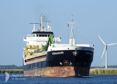
KJERVAAGSUND
General Cargo
Current Trip
| Time Travelled | 1 day |
|---|---|
| Remaining Time | --- |
| Distance Travelled | 379.30 nm |
| Remaining Distance | --- |
| AVG Speed | 10.3 Knop |
| MAX Speed | 12 Knop |
| AVG Wind | 9.5 knots |
| MAX Wind | 16.9 knots |
| MIN Temp | 3.1°C / 37.58°F |
| MAX Temp | 8.3°C / 46.94°F |
| Djupgående | 5.1 m |
| Position mottagen | 1 h, 43 m sen |
Current Position
| Longitud | 16.86746° |
|---|---|
| Latitude | 56.14624° |
| Status | Under way using engine |
| Fart | 11.4 Knop |
| Kurs | 14° |
| Område | Baltic Sea |
| Station | T-AIS |
| Position mottagen | 1 h, 43 m sen |
Info
Information
The current position of KJERVAAGSUND is in Baltic Sea with coordinates 56.14624° / 16.86746° as reported on 2024-04-26 06:05 by AIS to our vessel tracker app. The vessel's current speed is 11.4 Knop and is heading at the port of KEMI. The estimated time of arrival as calculated by MyShipTracking vessel tracking app is 2024-04-28 23:30 LT
The vessel KJERVAAGSUND (IMO: 9312690, MMSI: 257036300) is a General Cargo that was built in 2005 ( 19 År gammal ). It's sailing under the flag of [NO] Norway.
In this page you can find informations about the vessels current position, last detected port calls, and current voyage information. If the vessels is not in coverage by AIS you will find the latest position.
The current position of KJERVAAGSUND is detected by our AIS receivers and we are not responsible for the reliability of the data. The last position was recorded while the vessel was in Coverage by the Ais receivers of our vessel tracking app.
The current draught of KJERVAAGSUND as reported by AIS is 5.1 meters
Weather
| Temperature | 3.1°C / 37.58°F |
|---|---|
| Wind Speed | 6 knots |
| Direction | 72° ENE |
| Pressure | 1009.6 hPa |
| Humidity | 83.5 % |
| Cloud Coverage | 100 % |
Featured Company
Last Port Calls
| Port | Arrival | Departure | Time In Port |
|---|---|---|---|
| 2024-04-23 17:32 | 2024-04-24 20:21 | 1 d | |
| 2024-04-22 01:38 | 2024-04-22 03:05 | 1 h | |
| 2024-04-20 23:13 | 2024-04-21 17:07 | 17 h | |
| 2024-04-17 03:25 | 2024-04-17 13:39 | 10 h | |
| 2024-04-09 14:02 | 2024-04-10 17:14 | 1 d | |
| 2024-03-28 21:02 | 2024-04-05 14:42 | 7 d | |
| 2024-03-25 05:33 | 2024-03-25 07:08 | 1 h | |
| 2024-03-24 01:06 | 2024-03-24 20:47 | 19 h | |
| 2024-03-22 05:50 | 2024-03-23 07:49 | 1 d | |
| 2024-03-09 06:38 | 2024-03-09 18:29 | 11 h |
Most Visited Ports (Last year)
| Port | Arrivals | |
|---|---|---|
| 17 | ||
| 7 | ||
| 6 | ||
| 6 | ||
| 4 | ||
| 3 |
Last Trips
| Origin | Departure | Destination | Arrival | Distance | |
|---|---|---|---|---|---|
| 2024-04-22 05:05 | 2024-04-23 19:32 | 421.16 nm | |||
| 2024-04-21 19:07 | 2024-04-22 03:38 | 91.83 nm | |||
| 2024-04-17 15:39 | 2024-04-21 01:13 | 730.17 nm | |||
| 2024-04-10 19:14 | 2024-04-17 05:25 | 1294.45 nm | |||
| 2024-04-05 16:42 | 2024-04-09 16:02 | 375.93 nm | |||
| 2024-03-25 08:08 | 2024-03-28 22:02 | 923.70 nm | |||
| 2024-03-24 21:47 | 2024-03-25 06:33 | 91.79 nm | |||
| 2024-03-23 08:49 | 2024-03-24 02:06 | 196.39 nm | |||
| 2024-03-09 20:29 | 2024-03-22 06:50 | 2154.41 nm | |||
| 2024-03-02 12:40 | 2024-03-09 08:38 | 1112.90 nm |
Events
| Tid | Event | Detaljer | Position / Dest | Information |
|---|---|---|---|---|
| 2024-04-26 06:12 | Status ändrad | Default Under way using engine |
56.16654 / 16.88121
FIKEM
|
Fart: 11.4 kn Kurs: 14° |
| 2024-04-26 06:05 | UTANFÖR täckningsområde |
56.14624 / 16.86746
Baltic Sea
FIKEM
|
Fart: 11.4 kn Kurs: 14° |
|
| 2024-04-26 05:53 | Status ändrad | Under way using engine Default |
56.10964 / 16.84462
FIKEM
|
Fart: 11.4 kn Kurs: 20° |
| 2024-04-26 05:32 | Status ändrad | Default Under way using engine |
56.06037 / 16.77136
FIKEM
|
Fart: 11.3 kn Kurs: 54.9° |
| 2024-04-26 00:46 | Upptäckt i hav | Swedish part of the Baltic Sea |
55.61807 / 15.36654
Baltic Sea
FIKEM
|
Fart: 11.4 kn Kurs: 62.4° |
| 2024-04-25 20:49 | Upptäckt i hav | Danish part of the Kattegat |
55.18467 / 14.30190
Kattegat
FIKEM
|
Fart: 11.1 kn Kurs: 81.2° |
| 2024-04-25 15:38 | Byter havsområde | Swedish part of the Baltic Sea Danish part of the Baltic Sea |
55.29836 / 12.64550
Baltic Sea
FIKEM
|
Fart: 10 kn Kurs: 111.9° |
| 2024-04-25 15:28 | Byter havsområde | Danish part of the Baltic Sea Danish part of the Kattegat |
55.32439 / 12.63784
Baltic Sea
FIKEM
|
Fart: 10.6 kn Kurs: 189.3° |
| 2024-04-25 15:26 | Byter havsområde | Danish part of the Kattegat Swedish part of the Kattegat |
55.33018 / 12.63954
Kattegat
FIKEM
|
Fart: 10.7 kn Kurs: 189.8° |
| 2024-04-25 14:40 | Byter havsområde | Swedish part of the Kattegat Danish part of the Kattegat |
55.46684 / 12.67649
Kattegat
FIKEM
|
Fart: 10.7 kn Kurs: 190.1° |