

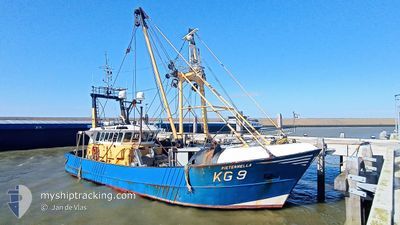
KG9 PIETERNELLA
Trawler

Current Trip
FISHNING GROUNDS
| Time Travelled | 13 h, 3 mins |
|---|---|
| Remaining Time | --- |
| Distance Travelled | 53.30 nm |
| Remaining Distance | --- |
| AVG Speed | 4.2 Knop |
| MAX Speed | 8.5 Knop |
| AVG Wind | 11 knots |
| MAX Wind | 17 knots |
| MIN Temp | 1.8°C / 35.24°F |
| MAX Temp | 3.4°C / 38.12°F |
| Djupgående | 2.7 m |
| Position mottagen | Nu |
Current Position
| Longitud | --- |
|---|---|
| Latitude | --- |
| Status | Engaged in Fishing |
| Fart | 1 Knop |
| Kurs | 153° |
| Område | North Sea |
| Station | T-AIS |
| Position mottagen | Nu |
Information
The current position of KG9 PIETERNELLA is in North Sea with coordinates 52.89442° / 4.56203° as reported on 2025-02-13 05:13 by AIS to our vessel tracker app. The vessel's current speed is 1 Knop
The vessel KG9 PIETERNELLA (IMO: 8516940, MMSI: 245364000) is a Trawler that was built in 1985 ( 40 År gammal ). It's sailing under the flag of [NL] Netherlands.
In this page you can find informations about the vessels current position, last detected port calls, and current voyage information. If the vessels is not in coverage by AIS you will find the latest position.
The current position of KG9 PIETERNELLA is detected by our AIS receivers and we are not responsible for the reliability of the data. The last position was recorded while the vessel was in Coverage by the Ais receivers of our vessel tracking app.
The current draught of KG9 PIETERNELLA as reported by AIS is 2.7 meters
Weather
| Temperature | 3.4°C / 38.12°F |
|---|---|
| Wind Speed | 17 knots |
| Direction | 48° NE |
| Pressure | 1020.7 hPa |
| Humidity | 68.8 % |
| Cloud Coverage | 100 % |


Featured Company
Last Port Calls
| Port | Arrival | Departure | Time In Port |
|---|---|---|---|
| 2025-02-12 11:30 | 2025-02-12 16:11 | 4 h | |
| 2025-02-06 12:57 | 2025-02-10 16:15 | 4 d | |
| 2025-02-03 15:51 | 2025-02-03 16:28 | 36 m | |
| 2025-02-03 04:03 | 2025-02-03 04:22 | 18 m | |
| 2025-01-23 10:44 | 2025-02-03 03:07 | 10 d | |
| 2025-01-23 09:37 | 2025-01-23 09:58 | 20 m | |
| 2025-01-19 22:30 | 2025-01-19 22:53 | 23 m | |
| 2025-01-16 12:05 | 2025-01-19 21:51 | 3 d | |
| 2025-01-16 11:09 | 2025-01-16 11:27 | 17 m | |
| 2025-01-12 22:42 | 2025-01-12 23:05 | 23 m |
Most Visited Ports (Last year)
| Port | Arrivals | |
|---|---|---|
| 30 | ||
| 22 | ||
| 14 | ||
| 12 | ||
| 7 | ||
| 1 |
Last Trips
| Origin | Departure | Destination | Arrival | Distance | |
|---|---|---|---|---|---|
| 2025-02-10 17:15 | 2025-02-12 12:30 | 134.69 nm | |||
| 2025-02-03 17:28 | 2025-02-06 13:57 | 205.56 nm | |||
| 2025-02-03 05:22 | 2025-02-03 16:51 | 99.35 nm | |||
| 2025-02-03 04:07 | 2025-02-03 05:03 | 6.09 nm | |||
| 2025-01-23 10:58 | 2025-01-23 11:44 | 5.98 nm | |||
| 2025-01-19 23:53 | 2025-01-23 10:37 | 332.69 nm | |||
| 2025-01-19 22:51 | 2025-01-19 23:30 | 6.25 nm | |||
| 2025-01-16 12:27 | 2025-01-16 13:05 | 5.83 nm | |||
| 2025-01-13 00:05 | 2025-01-16 12:09 | 332.06 nm | |||
| 2025-01-12 22:55 | 2025-01-12 23:42 | 6.22 nm |
Events
| Tid | Event | Detaljer | Position / Dest | Information |
|---|---|---|---|---|
| 2025-02-13 05:09 | STOPPAR förflyttning | 9 nm, South West of DEN HELDER |
52.89482 / 4.56262
FISHNING GROUNDS
|
Fart: 0.2 kn Kurs: 188° |
| 2025-02-13 03:39 | STARTAR förflyttning | 9.6 nm, North West of HARGEN |
52.87375 / 4.55935
FISHNING GROUNDS
|
Fart: 3.1 kn Kurs: 181° |
| 2025-02-13 03:34 | STOPPAR förflyttning | 9.63 nm, South West of DEN HELDER |
52.87564 / 4.56020
FISHNING GROUNDS
|
Fart: 0.3 kn Kurs: 188° |
| 2025-02-12 17:26 | STARTAR förflyttning | 7.07 nm, South West of DEN HELDER |
52.89712 / 4.62100
FISHNING GROUNDS
|
Fart: 3.1 kn Kurs: 239° |
| 2025-02-12 17:24 | STOPPAR förflyttning | 6.94 nm, South West of DEN HELDER |
52.89834 / 4.62381
FISHNING GROUNDS
|
Fart: 0.3 kn Kurs: 235° |
| 2025-02-12 16:11 | AVGÅTT HAMN |
|
52.96690 / 4.78716
FISHNING GROUNDS
|
Fart: 7.5 kn Kurs: 344° |
| 2025-02-12 16:02 | STARTAR förflyttning |
52.95389 / 4.78133
[NL] DEN HELDER
|
Fart: 4 kn Kurs: 318° |
|
| 2025-02-12 11:31 | STOPPAR förflyttning |
52.95178 / 4.78380
[NL] DEN HELDER
|
Fart: 0.3 kn Kurs: 136° |
|
| 2025-02-12 11:30 | ANLÄNDER HAMN |
|
52.95179 / 4.78381
[NL] DEN HELDER
|
Fart: 0.9 kn Kurs: 137° |
| 2025-02-12 11:02 | STARTAR förflyttning | 1.44 nm, North West of DEN HELDER |
52.96950 / 4.75107
FISHNING GROUNDS
|
Fart: 5.9 kn Kurs: 93.4° |