
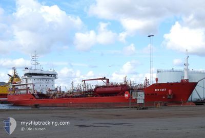
KEY EAST
Oil/Chemical Tanker
Current Trip
Unknown
| Time Travelled | 4 days |
|---|---|
| Remaining Time | --- |
| Distance Travelled | 970.15 nm |
| Remaining Distance | --- |
| AVG Speed | 8.6 Knop |
| MAX Speed | 14.3 Knop |
| AVG Wind | 16.2 knots |
| MAX Wind | 31.8 knots |
| MIN Temp | 0.3°C / 32.54°F |
| MAX Temp | 7.1°C / 44.78°F |
| Djupgående | 4.9 m |
| Position mottagen | 1 m sen |
Current Position
| Longitud | 4.65877° |
|---|---|
| Latitude | 59.76881° |
| Status | Under way using engine |
| Fart | 12.1 Knop |
| Kurs | 173° |
| Område | North Sea |
| Station | T-AIS |
| Position mottagen | 1 m sen |
Info
Information
The current position of KEY EAST is in North Sea with coordinates 59.76881° / 4.65877° as reported on 2024-04-27 05:16 by AIS to our vessel tracker app. The vessel's current speed is 12.1 Knop
The vessel KEY EAST (IMO: 9525584, MMSI: 229015000) is a Oil/Chemical Tanker that was built in 2011 ( 13 År gammal ). It's sailing under the flag of [MT] Malta.
In this page you can find informations about the vessels current position, last detected port calls, and current voyage information. If the vessels is not in coverage by AIS you will find the latest position.
The current position of KEY EAST is detected by our AIS receivers and we are not responsible for the reliability of the data. The last position was recorded while the vessel was in Coverage by the Ais receivers of our vessel tracking app.
The current draught of KEY EAST as reported by AIS is 4.9 meters
Weather
| Temperature | 6.8°C / 44.24°F |
|---|---|
| Wind Speed | 3 knots |
| Direction | 69° ENE |
| Pressure | 1011.2 hPa |
| Humidity | 71.4 % |
| Cloud Coverage | 52 % |
Featured Company
Last Port Calls
| Port | Arrival | Departure | Time In Port |
|---|---|---|---|
| 2024-04-22 03:30 | 2024-04-22 16:09 | 12 h | |
| 2024-04-17 21:45 | 2024-04-18 13:55 | 16 h | |
| 2024-04-17 21:34 | 2024-04-17 21:41 | 6 m | |
| 2024-04-16 20:23 | 2024-04-17 10:02 | 13 h | |
| 2024-04-15 21:20 | 2024-04-16 10:03 | 12 h | |
| 2024-04-11 19:05 | 2024-04-12 12:01 | 16 h | |
| 2024-04-11 02:30 | 2024-04-11 02:54 | 23 m | |
| 2024-04-10 08:15 | 2024-04-10 23:20 | 15 h | |
| 2024-04-06 12:58 | 2024-04-06 18:58 | 6 h | |
| 2024-04-01 14:35 | 2024-04-02 03:38 | 13 h |
Most Visited Ports (Last year)
| Port | Arrivals | |
|---|---|---|
| 82 | ||
| 17 | ||
| 16 | ||
| 15 | ||
| 3 | ||
| 3 |
Last Trips
| Origin | Departure | Destination | Arrival | Distance | |
|---|---|---|---|---|---|
| 2024-04-18 15:55 | 2024-04-22 05:30 | 687.20 nm | |||
| 2024-04-17 23:41 | 2024-04-17 23:45 | 0.02 nm | |||
| 2024-04-17 12:02 | 2024-04-17 23:34 | 123.95 nm | |||
| 2024-04-16 12:03 | 2024-04-16 22:23 | 125.34 nm | |||
| 2024-04-12 14:01 | 2024-04-15 23:20 | 681.75 nm | |||
| 2024-04-11 04:54 | 2024-04-11 21:05 | 43.74 nm | |||
| 2024-04-11 01:20 | 2024-04-11 04:30 | 35.14 nm | |||
| 2024-04-06 20:58 | 2024-04-10 10:15 | 796.72 nm | |||
| 2024-04-02 05:38 | 2024-04-06 14:58 | 875.78 nm | |||
| 2024-04-01 04:57 | 2024-04-01 16:35 | 122.83 nm |
Events
| Tid | Event | Detaljer | Position / Dest | Information |
|---|---|---|---|---|
| 2024-04-26 23:18 | Byter havsområde | Norwegian part of the North Sea Norwegian part of the Norwegian Sea |
60.99778 / 4.38400
North Sea
|
Fart: 12.4 kn Kurs: 182° |
| 2024-04-26 13:11 | ETA ändrat | 2024/04/28 07:00 2024/06/24 20:20 |
62.84385 / 6.20168
SLAGEN
|
Fart: 13 kn Kurs: 227° |
| 2024-04-26 12:14 | Status ändrad | Under way using engine Default |
62.98612 / 6.51595
SLAGEN
|
Fart: 12.8 kn Kurs: 232° |
| 2024-04-26 12:12 | Status ändrad | Default Under way using engine |
62.98978 / 6.52630
SLAGEN
|
Fart: 12.8 kn Kurs: 232° |
| 2024-04-26 09:25 | ETA ändrat | 2024/06/24 20:20 2024/04/28 07:00 |
63.24916 / 7.58521
SLAGEN
|
Fart: 9.6 kn Kurs: 271° |
| 2024-04-26 02:17 | STARTAR förflyttning | 1.28 nm, North West of TRONDHEIM |
63.44579 / 10.34626
SLAGEN
|
Fart: 4.6 kn Kurs: 3° |
| 2024-04-26 02:14 | Status ändrad | Under way using engine Moored |
63.44400 / 10.34676
SLAGEN
|
Fart: 0.5 kn Kurs: 322° |
| 2024-04-26 02:08 | Status ändrad | Moored Under way using engine |
63.44374 / 10.34646
SLAGEN
|
Fart: Kurs: 297° |
| 2024-04-26 02:07 | Status ändrad | Under way using engine Moored |
63.44374 / 10.34647
SLAGEN
|
Fart: Kurs: 297° |
| 2024-04-26 01:15 | Destination ändrad | SLAGEN TRONDHEIM |
63.44375 / 10.34643
SLAGEN
|
Fart: Kurs: 298° |