
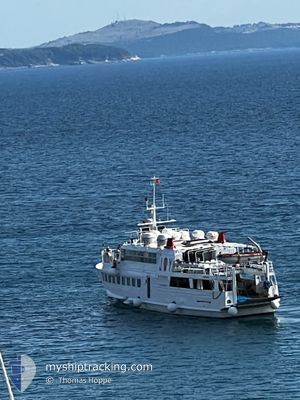
JOY STAR
Passengers Ship
Current Trip
| Trip Time | 58 mins |
|---|---|
| Trip Distance | 7.93 nm |
| AVG Speed | 8.6 Knop |
| MAX Speed | 11.2 Knop |
| Djupgående | 0 m |
| AVG Wind | 15.9 knots |
| MAX Wind | 17 knots |
| MIN Temp | 16.4°C / 61.52°F |
| MAX Temp | 16.5°C / 61.7°F |
| Position mottagen | 14 h, 23 m sen |
Current Position
| Longitud | --- |
|---|---|
| Latitude | --- |
| Status | Moored |
| Fart | 0.4 Knop |
| Kurs | --- |
| Område | Aegean Sea |
| Station | T-AIS |
| Position mottagen | 14 h, 23 m sen |
Info
Information
The current position of JOY STAR is in Aegean Sea with coordinates 37.61486° / 26.29654° as reported on 2025-03-17 11:23 by AIS to our vessel tracker app. The vessel's current speed is 0.4 Knop and is currently inside the port of FOURNI.
The vessel JOY STAR (IMO: 8869270, MMSI: 241609000) is a Passengers Ship that was built in 1993 ( 32 År gammal ). It's sailing under the flag of [GR] Greece.
In this page you can find informations about the vessels current position, last detected port calls, and current voyage information. If the vessels is not in coverage by AIS you will find the latest position.
The current position of JOY STAR is detected by our AIS receivers and we are not responsible for the reliability of the data. The last position was recorded while the vessel was in Coverage by the Ais receivers of our vessel tracking app.
Weather
| Temperature | 16.7°C / 62.06°F |
|---|---|
| Wind Speed | 6 knots |
| Direction | 302° WNW |
| Pressure | 1010.2 hPa |
| Humidity | 69.2 % |
| Cloud Coverage | 51 % |
Featured Company
Last Port Calls
| Port | Arrival | Departure | Time In Port |
|---|---|---|---|
| 2025-03-17 15:30 | |||
| 2025-03-17 14:32 | |||
| 2025-03-17 11:34 | |||
| 2025-03-17 11:34 | |||
| 2025-03-16 18:39 | |||
| 2025-03-16 09:51 | 2025-03-16 16:12 | 6 h | |
| 2025-03-16 07:55 | 2025-03-16 08:11 | 16 m | |
| 2025-03-15 20:51 | 2025-03-16 06:03 | 9 h | |
| 2025-03-15 09:32 | 2025-03-15 15:56 | 6 h | |
| 2025-03-14 18:58 | 2025-03-15 06:38 | 11 h |
Last Trips
| Origin | Departure | Destination | Arrival | Distance | |
|---|---|---|---|---|---|
| 2025-03-17 14:32 | 2025-03-17 15:30 | 7.93 nm | |||
| 2025-03-16 16:12 | 2025-03-17 11:34 | 39.55 nm | |||
| 2025-03-16 16:12 | 2025-03-16 18:39 | 21.69 nm | |||
| 2025-03-16 08:11 | 2025-03-16 09:51 | 15.31 nm | |||
| 2025-03-16 06:03 | 2025-03-16 07:55 | 14.56 nm | |||
| 2025-03-15 15:56 | 2025-03-15 20:51 | 30.91 nm | |||
| 2025-03-15 06:38 | 2025-03-15 09:32 | 26.18 nm | |||
| 2025-03-14 17:16 | 2025-03-14 18:58 | 11.05 nm | |||
| 2025-03-14 17:05 | 2025-03-14 17:12 | 0.80 nm | |||
| 2025-03-14 14:36 | 2025-03-14 14:58 | 3.72 nm |
Events
| Tid | Event | Detaljer | Position / Dest | Information |
|---|---|---|---|---|
| 2025-03-17 13:52 | STOPPAR förflyttning |
37.57840 / 26.47803
[GR] FOURNI
|
Fart: Kurs: -1° |
|
| 2025-03-17 13:30 | ANLÄNDER HAMN |
|
37.57770 / 26.47765
[GR] FOURNI
|
Fart: 10.7 kn Kurs: 166° |
| 2025-03-17 12:39 | STARTAR förflyttning | 1.18 nm, East of AGIOS KYRIKOS |
37.61237 / 26.32274
GRFOU
|
Fart: 11 kn Kurs: -1° |
| 2025-03-17 12:32 | AVGÅTT HAMN |
|
37.61237 / 26.32274
GRFOU
|
Fart: Kurs: -1° |
| 2025-03-17 11:42 | Status ändrad | Default Moored |
37.61491 / 26.29647
[GR] AGIOS KYRIKOS
|
Fart: 0.4 kn Kurs: 511° |
| 2025-03-17 11:23 | UTANFÖR täckningsområde |
37.61486 / 26.29654
Aegean Sea
[GR] AGIOS KYRIKOS
|
Fart: 0.4 kn Kurs: 511° |
|
| 2025-03-17 09:34 | I täckningsområde |
37.61481 / 26.29650
Aegean Sea
[GR] AGIOS KYRIKOS
|
Fart: 0.3 kn Kurs: 511° |
|
| 2025-03-17 09:34 | AVGÅTT HAMN |
|
37.61481 / 26.29650
GRFOU
|
Fart: 0.2 kn Kurs: 511° |
| 2025-03-17 09:34 | ANLÄNDER HAMN |
|
37.61481 / 26.29650
[GR] AGIOS KYRIKOS
|
Fart: 0.2 kn Kurs: 511° |
| 2025-03-16 21:58 | UTANFÖR täckningsområde |
37.57838 / 26.47800
Aegean Sea
[GR] FOURNI
|
Fart: 0.2 kn Kurs: 511° |