
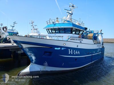
JANNETJE CORNELIS
Fishing
Current Trip
FISHINGGROUND
| Time Travelled | 3 days |
|---|---|
| Remaining Time | --- |
| Distance Travelled | 304.60 nm |
| Remaining Distance | --- |
| AVG Speed | 8 Knop |
| MAX Speed | 12 Knop |
| AVG Wind | 9.2 knots |
| MAX Wind | 17.2 knots |
| MIN Temp | 8.6°C / 47.48°F |
| MAX Temp | 14.5°C / 58.1°F |
| Djupgående | 5.5 m |
| Position mottagen | 7 m sen |
Current Position
| Longitud | 1.76044° |
|---|---|
| Latitude | 51.34430° |
| Status | Engaged in Fishing |
| Fart | 1.3 Knop |
| Kurs | 359° |
| Område | North Sea |
| Station | T-AIS |
| Position mottagen | 7 m sen |
Info
Information
The current position of JANNETJE CORNELIS is in North Sea with coordinates 51.34430° / 1.76044° as reported on 2024-05-02 09:56 by AIS to our vessel tracker app. The vessel's current speed is 1.3 Knop
The vessel JANNETJE CORNELIS (IMO: 9847255, MMSI: 232018240) is a Fishing It's sailing under the flag of [GB] United Kingdom.
In this page you can find informations about the vessels current position, last detected port calls, and current voyage information. If the vessels is not in coverage by AIS you will find the latest position.
The current position of JANNETJE CORNELIS is detected by our AIS receivers and we are not responsible for the reliability of the data. The last position was recorded while the vessel was in Coverage by the Ais receivers of our vessel tracking app.
The current draught of JANNETJE CORNELIS as reported by AIS is 5.5 meters
Weather
| Temperature | 11.7°C / 53.06°F |
|---|---|
| Wind Speed | 12 knots |
| Direction | 220° SW |
| Pressure | 999.5 hPa |
| Humidity | 95.4 % |
| Cloud Coverage | 100 % |
Featured Company
Last Port Calls
| Port | Arrival | Departure | Time In Port |
|---|---|---|---|
| 2024-04-25 20:25 | 2024-04-29 00:24 | 3 d | |
| 2024-04-19 04:39 | 2024-04-22 00:29 | 2 d | |
| 2024-04-18 00:07 | 2024-04-18 01:17 | 1 h | |
| 2024-04-11 18:10 | 2024-04-15 00:34 | 3 d | |
| 2024-04-04 23:54 | 2024-04-08 00:29 | 3 d | |
| 2024-03-28 21:38 | 2024-04-01 19:00 | 3 d | |
| 2024-03-28 10:42 | 2024-03-28 10:43 | 1 m | |
| 2024-03-21 22:40 | 2024-03-25 12:23 | 3 d | |
| 2024-03-14 20:37 | 2024-03-18 01:36 | 3 d | |
| 2024-03-07 20:56 | 2024-03-11 01:33 | 3 d |
Most Visited Ports (Last year)
| Port | Arrivals | |
|---|---|---|
| 44 | ||
| 13 | ||
| 8 | ||
| 1 | ||
| 1 | ||
| 1 |
Last Trips
| Origin | Departure | Destination | Arrival | Distance | |
|---|---|---|---|---|---|
| 2024-04-22 02:29 | 2024-04-25 22:25 | 478.20 nm | |||
| 2024-04-18 03:17 | 2024-04-19 06:39 | 182.73 nm | |||
| 2024-04-15 02:34 | 2024-04-18 02:07 | 371.48 nm | |||
| 2024-04-08 02:29 | 2024-04-11 20:10 | 416.61 nm | |||
| 2024-04-01 21:00 | 2024-04-05 01:54 | 344.37 nm | |||
| 2024-03-28 10:43 | 2024-03-28 22:38 | 96.60 nm | |||
| 2024-03-25 13:23 | 2024-03-28 10:42 | 295.49 nm | |||
| 2024-03-18 02:36 | 2024-03-21 23:40 | 200.24 nm | |||
| 2024-03-11 02:33 | 2024-03-14 21:37 | 520.15 nm | |||
| 2024-03-04 02:37 | 2024-03-07 21:56 | 434.60 nm |
Events
| Tid | Event | Detaljer | Position / Dest | Information |
|---|---|---|---|---|
| 2024-05-02 05:29 | STARTAR förflyttning | 12.85 nm, East of RAMSGATE |
51.34391 / 1.76156
FISHINGGROUND
|
Fart: 3.1 kn Kurs: 165° |
| 2024-05-02 03:57 | STOPPAR förflyttning | 12.74 nm, East of RAMSGATE |
51.35163 / 1.75732
FISHINGGROUND
|
Fart: 0.2 kn Kurs: 215° |
| 2024-05-02 00:04 | I täckningsområde |
51.41913 / 1.79579
North Sea
|
Fart: 4.7 kn Kurs: 223° |
|
| 2024-05-01 21:57 | UTANFÖR täckningsområde |
51.52954 / 1.97175
North Sea
|
Fart: 5.6 kn Kurs: 225° |
|
| 2024-05-01 21:06 | Byter havsområde | United Kingdom part of the North Sea Belgian part of the North Sea |
51.58717 / 2.06270
North Sea
|
Fart: 5.7 kn Kurs: 222° |
| 2024-05-01 21:05 | I täckningsområde |
51.58717 / 2.06270
North Sea
|
Fart: 5.7 kn Kurs: 222° |
|
| 2024-05-01 02:16 | UTANFÖR täckningsområde |
51.38431 / 2.52778
North Sea
|
Fart: 10.6 kn Kurs: 266° |
|
| 2024-04-30 23:31 | Byter havsområde | Belgian part of the North Sea Dutch part of the North Sea |
51.41322 / 3.32386
North Sea
|
Fart: 11.4 kn Kurs: 272° |
| 2024-04-30 22:35 | STARTAR förflyttning | 0.55 nm, South East of VLISSINGEN STATION |
51.44128 / 3.60139
FISHINGGROUND
|
Fart: 7.9 kn Kurs: 141° |
| 2024-04-30 22:01 | STOPPAR förflyttning | 0.43 nm, South East of VLISSINGEN STATION |
51.44230 / 3.59851
FISHINGGROUND
|
Fart: 0.3 kn Kurs: 290° |