
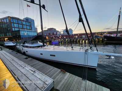
INTERLAGOS
Sailing
Current Trip
Unknown
| Time Travelled | 3 days |
|---|---|
| Remaining Time | --- |
| Distance Travelled | 50.52 nm |
| Remaining Distance | --- |
| AVG Speed | 7.3 Knop |
| MAX Speed | 11 Knop |
| AVG Wind | 14.2 knots |
| MAX Wind | 20 knots |
| MIN Temp | 25°C / 77°F |
| MAX Temp | 26.2°C / 79.16°F |
| Djupgående | --- |
| Position mottagen | 1 m sen |
Current Position
| Longitud | --- |
|---|---|
| Latitude | --- |
| Status | Default |
| Fart | 0.2 Knop |
| Kurs | --- |
| Område | Caribbean Sea |
| Station | T-AIS |
| Position mottagen | 1 m sen |
Info
Information
The current position of INTERLAGOS is in Caribbean Sea with coordinates 18.35468° / -64.60265° as reported on 2025-02-25 10:15 by AIS to our vessel tracker app. The vessel's current speed is 0.2 Knop
The vessel INTERLAGOS (MMSI: 538071900) is a Sailing It's sailing under the flag of [MH] Marshall Is.
In this page you can find informations about the vessels current position, last detected port calls, and current voyage information. If the vessels is not in coverage by AIS you will find the latest position.
The current position of INTERLAGOS is detected by our AIS receivers and we are not responsible for the reliability of the data. The last position was recorded while the vessel was in Coverage by the Ais receivers of our vessel tracking app.
Weather
| Temperature | 25.9°C / 78.62°F |
|---|---|
| Wind Speed | 19 knots |
| Direction | 108° ESE |
| Pressure | 1014.7 hPa |
| Humidity | 72.6 % |
| Cloud Coverage | 1 % |
Featured Company
Last Port Calls
| Port | Arrival | Departure | Time In Port |
|---|---|---|---|
| 2025-02-21 17:10 | 2025-02-21 18:19 | 1 h | |
| 2025-01-25 16:13 | 2025-02-19 16:08 | 24 d | |
| 2025-01-24 20:37 | 2025-01-25 14:22 | 17 h | |
| 2025-01-19 15:25 | 2025-01-22 12:33 | 2 d | |
| 2025-01-18 15:38 | 2025-01-19 14:39 | 23 h | |
| 2025-01-18 14:38 | 2025-01-18 14:42 | 3 m | |
| 2024-12-31 16:09 | 2024-12-31 17:54 | 1 h | |
| 2024-12-31 14:22 |
Most Visited Ports (Last year)
| Port | Arrivals | |
|---|---|---|
| 5 | ||
| 2 | ||
| 1 | ||
| 1 | ||
| 1 | ||
| 1 |
Last Trips
| Origin | Departure | Destination | Arrival | Distance | |
|---|---|---|---|---|---|
| 2025-02-19 12:08 | 2025-02-21 13:10 | 39.73 nm | |||
| 2025-01-25 10:22 | 2025-01-25 12:13 | 14.88 nm | |||
| 2025-01-22 08:33 | 2025-01-24 16:37 | 50.00 nm | |||
| 2025-01-19 10:39 | 2025-01-19 11:25 | 6.37 nm | |||
| 2025-01-18 10:42 | 2025-01-18 11:38 | 6.56 nm | |||
| 2024-12-31 13:54 | 2025-01-18 10:38 | 152.50 nm | |||
| 2024-12-31 10:22 | 2024-12-31 12:09 | 13.64 nm |
Events
| Tid | Event | Detaljer | Position / Dest | Information |
|---|---|---|---|---|
| 2025-02-24 17:10 | STOPPAR förflyttning | 2.34 nm, North of NORMAN ISLAND |
18.35463 / -64.60225
|
Fart: 0.3 kn Kurs: 511° |
| 2025-02-24 14:35 | STARTAR förflyttning | 4.76 nm, North East of VIRGIN GORDA |
18.49971 / -64.37281
|
Fart: 3.3 kn Kurs: 176.1° |
| 2025-02-23 03:49 | I täckningsområde |
18.50280 / -64.37046
Caribbean Sea
|
Fart: 0.2 kn Kurs: 246.6° |
|
| 2025-02-23 01:07 | UTANFÖR täckningsområde |
18.50268 / -64.37052
Caribbean Sea
|
Fart: 0.3 kn Kurs: 205.1° |
|
| 2025-02-22 21:16 | STOPPAR förflyttning | 5 nm, North East of VIRGIN GORDA |
18.50271 / -64.37004
|
Fart: 0.3 kn Kurs: 511° |
| 2025-02-22 20:09 | STARTAR förflyttning | 1.2 nm, South West of VIRGIN GORDA |
18.43309 / -64.44827
|
Fart: 7.2 kn Kurs: 336.8° |
| 2025-02-22 15:53 | STOPPAR förflyttning | 1.32 nm, South of VIRGIN GORDA |
18.43043 / -64.44731
|
Fart: 0.3 kn Kurs: 511° |
| 2025-02-22 13:22 | STARTAR förflyttning | 2.14 nm, East of JOST VAN DYKE |
18.44942 / -64.71408
|
Fart: 4.7 kn Kurs: 195.8° |
| 2025-02-22 10:23 | I täckningsområde |
18.45177 / -64.71380
Caribbean Sea
|
Fart: 0.3 kn Kurs: 315.6° |
|
| 2025-02-22 08:47 | UTANFÖR täckningsområde |
18.45184 / -64.71384
Caribbean Sea
|
Fart: 0.2 kn Kurs: 511° |