
INCE POINT
Cargo
Current Trip
KUNSAN
| Time Travelled | 19 h, 20 mins |
|---|---|
| Remaining Time | --- |
| Distance Travelled | --- |
| Remaining Distance | --- |
| AVG Speed | --- |
| MAX Speed | --- |
| AVG Wind | --- |
| MAX Wind | --- |
| MIN Temp | --- |
| MAX Temp | --- |
| Djupgående | 10.8 m |
| Position mottagen | 4 d sen |
Current Position
| Longitud | 126.36571° |
|---|---|
| Latitude | 35.93976° |
| Status | At anchor |
| Fart | |
| Kurs | 18° |
| Område | Yellow Sea |
| Station | T-AIS |
| Position mottagen | 4 d sen |
Info
Information
The current position of INCE POINT is in Yellow Sea with coordinates 35.93976° / 126.36571° as reported on 2024-06-25 00:17 by AIS to our vessel tracker app. The vessel's current speed is 0 Knop
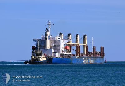
The vessel INCE POINT (IMO: 9663271, MMSI: 477231500) is a Cargo It's sailing under the flag of [HK] Hong Kong.
In this page you can find informations about the vessels current position, last detected port calls, and current voyage information. If the vessels is not in coverage by AIS you will find the latest position.
The current position of INCE POINT is detected by our AIS receivers and we are not responsible for the reliability of the data. The last position was recorded while the vessel was in Coverage by the Ais receivers of our vessel tracking app.
The current draught of INCE POINT as reported by AIS is 10.8 meters
Weather
| Temperature | 23.3°C / 73.94°F |
|---|---|
| Wind Speed | 22 knots |
| Direction | 203° SSW |
| Pressure | 1000.6 hPa |
| Humidity | 96.9 % |
| Cloud Coverage | 100 % |
Featured Company
Last Port Calls
| Port | Arrival | Departure | Time In Port |
|---|---|---|---|
| 2024-06-25 18:20 | 2024-06-29 00:10 | 3 d | |
| 2024-05-23 00:41 | 2024-05-29 21:33 | 6 d | |
| 2024-05-18 08:01 | 2024-05-21 21:39 | 3 d | |
| 2024-04-29 22:23 | 2024-05-11 22:39 | 12 d | |
| 2024-04-21 05:56 | 2024-04-24 06:17 | 3 d | |
| 2024-04-11 16:56 | 2024-04-13 05:57 | 1 d |
Last Trips
| Origin | Departure | Destination | Arrival | Distance | |
|---|---|---|---|---|---|
| 2024-05-30 09:33 | 2024-06-26 03:20 | 5597.32 nm | |||
| 2024-05-22 09:39 | 2024-05-23 12:41 | 188.84 nm | |||
| 2024-05-12 08:39 | 2024-05-18 20:01 | 1566.55 nm | |||
| 2024-04-24 14:17 | 2024-04-30 08:23 | 1539.67 nm | |||
| 2024-04-13 15:57 | 2024-04-21 13:56 | 1862.24 nm | |||
| 2024-04-01 07:55 | 2024-04-12 02:56 | 601.11 nm |
Events
| Tid | Event | Detaljer | Position / Dest | Information |
|---|---|---|---|---|
| 2024-06-29 00:14 | STARTAR förflyttning | 3.14 nm, West of GUNSAN |
35.97731 / 126.52684
KUNSAN
|
Fart: 4.1 kn Kurs: 295° |
| 2024-06-29 00:10 | AVGÅTT HAMN |
|
35.97731 / 126.52684
KUNSAN
|
Fart: Kurs: 85° |
| 2024-06-25 18:22 | STOPPAR förflyttning |
35.97435 / 126.52948
[KR] GUNSAN
|
Fart: 0.2 kn Kurs: 82° |
|
| 2024-06-25 18:20 | ANLÄNDER HAMN |
|
35.97456 / 126.52942
[KR] GUNSAN
|
Fart: 2 kn Kurs: 93° |
| 2024-06-25 16:53 | STARTAR förflyttning | 10.51 nm, West of GUNSAN |
35.94231 / 126.38030
KUNSAN
|
Fart: 4.8 kn Kurs: 75° |
| 2024-06-25 00:26 | Status ändrad | Default At anchor |
35.93988 / 126.36562
KUNSAN
|
Fart: Kurs: 18° |
| 2024-06-25 00:17 | UTANFÖR täckningsområde |
35.93976 / 126.36571
Yellow Sea
|
Fart: Kurs: 204.3° |
|
| 2024-06-24 23:59 | Status ändrad | At anchor Default |
35.93972 / 126.36585
KUNSAN
|
Fart: Kurs: 13° |
| 2024-06-24 23:53 | Status ändrad | Default At anchor |
35.93970 / 126.36587
KUNSAN
|
Fart: 0.1 kn Kurs: 13° |
| 2024-06-24 23:17 | Status ändrad | At anchor Default |
35.93962 / 126.36642
KUNSAN
|
Fart: 0.1 kn Kurs: 353° |