
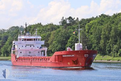
HUNZEDIJK
General Cargo
Current Trip
| Time Travelled | 7 days |
|---|---|
| Remaining Time | --- |
| Distance Travelled | 228.79 nm |
| Remaining Distance | --- |
| AVG Speed | 6.2 Knop |
| MAX Speed | 11.9 Knop |
| AVG Wind | 24.3 knots |
| MAX Wind | 35 knots |
| MIN Temp | 1°C / 33.8°F |
| MAX Temp | 7.1°C / 44.78°F |
| Djupgående | 3.9 m |
| Position mottagen | 6 m sen |
Current Position
| Longitud | --- |
|---|---|
| Latitude | --- |
| Status | At anchor |
| Fart | 0.1 Knop |
| Kurs | 207° |
| Område | North Sea |
| Station | T-AIS |
| Position mottagen | 6 m sen |
Info
Information
The current position of HUNZEDIJK is in North Sea with coordinates 54.70334° / -1.02108° as reported on 2026-01-06 22:10 by AIS to our vessel tracker app. The vessel's current speed is 0.1 Knop
The vessel HUNZEDIJK (IMO: 9515022, MMSI: 246765000) is a General Cargo that was built in 2011 ( 15 År gammal ). It's sailing under the flag of [NL] Netherlands.
In this page you can find informations about the vessels current position, last detected port calls, and current voyage information. If the vessels is not in coverage by AIS you will find the latest position.
The current position of HUNZEDIJK is detected by our AIS receivers and we are not responsible for the reliability of the data. The last position was recorded while the vessel was in Coverage by the Ais receivers of our vessel tracking app.
The current draught of HUNZEDIJK as reported by AIS is 3.9 meters
Weather
| Temperature | 5.3°C / 41.54°F |
|---|---|
| Wind Speed | 22 knots |
| Direction | 277° W |
| Pressure | 997.5 hPa |
| Humidity | 78.1 % |
| Cloud Coverage | 100 % |
Featured Company
Last Port Calls
| Port | Arrival | Departure | Time In Port |
|---|---|---|---|
| 2025-12-22 20:47 | 2025-12-30 16:28 | 7 d | |
| 2025-12-14 17:10 | 2025-12-14 21:46 | 4 h | |
| 2025-12-01 11:26 | 2025-12-08 12:39 | 7 d | |
| 2025-11-27 14:45 |
Events
| Tid | Event | Detaljer | Position / Dest | Information |
|---|---|---|---|---|
| 2026-01-06 21:22 | Status ändrad | At anchor Default |
54.70358 / -1.02180
GB TEE
|
Fart: 0.5 kn Kurs: 191° |
| 2026-01-06 21:04 | Status ändrad | Default At anchor |
54.70347 / -1.02126
GB TEE
|
Fart: 0.5 kn Kurs: 178° |
| 2026-01-06 20:52 | Status ändrad | At anchor Default |
54.70348 / -1.02143
GB TEE
|
Fart: Kurs: -1° |
| 2026-01-06 20:50 | Status ändrad | Default At anchor |
54.70334 / -1.02167
GB TEE
|
Fart: 0.4 kn Kurs: 211° |
| 2026-01-06 20:37 | Status ändrad | At anchor Default |
54.70349 / -1.02152
GB TEE
|
Fart: 0.2 kn Kurs: 236° |
| 2026-01-06 20:29 | Status ändrad | Default At anchor |
54.70334 / -1.02167
GB TEE
|
Fart: 0.5 kn Kurs: 239° |
| 2026-01-06 20:22 | Status ändrad | At anchor Default |
54.70346 / -1.02138
GB TEE
|
Fart: 0.7 kn Kurs: 232° |
| 2026-01-06 20:16 | Status ändrad | Default At anchor |
54.70338 / -1.02127
GB TEE
|
Fart: 0.4 kn Kurs: 197° |
| 2026-01-06 19:25 | Status ändrad | At anchor Default |
54.70350 / -1.02156
GB TEE
|
Fart: 0.5 kn Kurs: 196° |
| 2026-01-06 19:16 | Status ändrad | Default At anchor |
54.70338 / -1.02133
GB TEE
|
Fart: 0.2 kn Kurs: 200° |