
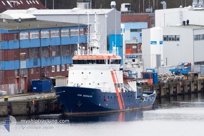
HDW HERKULES
Offshore Supply Ship
Current Trip
SUBMARINESAFETYVSL
| Time Travelled | 3 days |
|---|---|
| Remaining Time | --- |
| Distance Travelled | 316.60 nm |
| Remaining Distance | --- |
| AVG Speed | 6 Knop |
| MAX Speed | 14.3 Knop |
| AVG Wind | 11.8 knots |
| MAX Wind | 19.6 knots |
| MIN Temp | 9.8°C / 49.64°F |
| MAX Temp | 14.6°C / 58.28°F |
| Djupgående | 4.9 m |
| Position mottagen | Nu |
Current Position
| Longitud | 8.50050° |
|---|---|
| Latitude | 58.15250° |
| Status | Restricted manoeuverability |
| Fart | 0.6 Knop |
| Kurs | 21° |
| Område | Skaggerak |
| Station | T-AIS |
| Position mottagen | Nu |
Info
Information
The current position of HDW HERKULES is in Skaggerak with coordinates 58.15250° / 8.50050° as reported on 2024-05-17 00:00 by AIS to our vessel tracker app. The vessel's current speed is 0.6 Knop
The vessel HDW HERKULES (IMO: 5148754, MMSI: 211399000) is a Offshore Supply Ship that was built in 1960 ( 64 År gammal ). It's sailing under the flag of [DE] Germany.
In this page you can find informations about the vessels current position, last detected port calls, and current voyage information. If the vessels is not in coverage by AIS you will find the latest position.
The current position of HDW HERKULES is detected by our AIS receivers and we are not responsible for the reliability of the data. The last position was recorded while the vessel was in Coverage by the Ais receivers of our vessel tracking app.
The current draught of HDW HERKULES as reported by AIS is 4.9 meters
Weather
| Temperature | 12.6°C / 54.68°F |
|---|---|
| Wind Speed | 4 knots |
| Direction | 55° NE |
| Pressure | 1018.8 hPa |
| Humidity | 61.9 % |
| Cloud Coverage | 64 % |
Featured Company
Last Port Calls
| Port | Arrival | Departure | Time In Port |
|---|---|---|---|
| 2024-05-09 05:47 | 2024-05-13 08:44 | 4 d | |
| 2024-05-06 09:28 | 2024-05-06 10:22 | 54 m | |
| 2024-05-03 06:51 | 2024-05-06 09:26 | 3 d | |
| 2024-04-26 05:37 | 2024-04-29 11:20 | 3 d | |
| 2024-04-24 16:56 | 2024-04-26 00:28 | 1 d | |
| 2024-04-23 19:56 | 2024-04-24 13:57 | 18 h | |
| 2024-04-23 15:16 | 2024-04-23 15:20 | 4 m | |
| 2024-04-22 13:03 | 2024-04-23 15:14 | 1 d | |
| 2024-04-18 12:52 | 2024-04-22 09:39 | 3 d | |
| 2024-04-11 14:56 | 2024-04-15 11:46 | 3 d |
Most Visited Ports (Last year)
| Port | Arrivals | |
|---|---|---|
| 14 | ||
| 12 | ||
| 1 | ||
| 1 | ||
| 1 | ||
| 1 |
Last Trips
| Origin | Departure | Destination | Arrival | Distance | |
|---|---|---|---|---|---|
| 2024-05-06 10:22 | 2024-05-09 05:47 | 218.63 nm | |||
| 2024-05-06 09:26 | 2024-05-06 09:28 | 0.94 nm | |||
| 2024-04-29 11:20 | 2024-05-03 06:51 | 542.63 nm | |||
| 2024-04-26 00:28 | 2024-04-26 05:37 | 26.17 nm | |||
| 2024-04-24 13:57 | 2024-04-24 16:56 | 25.89 nm | |||
| 2024-04-23 15:20 | 2024-04-23 19:56 | 17.29 nm | |||
| 2024-04-23 15:14 | 2024-04-23 15:16 | 0.33 nm | |||
| 2024-04-22 09:39 | 2024-04-22 13:03 | 18.90 nm | |||
| 2024-04-15 11:46 | 2024-04-18 12:52 | 46.95 nm | |||
| 2024-04-08 10:22 | 2024-04-11 14:56 | 442.66 nm |
Events
| Tid | Event | Detaljer | Position / Dest | Information |
|---|---|---|---|---|
| 2024-05-16 18:32 | STOPPAR förflyttning | 9.08 nm, South East of LILLESAND |
58.17065 / 8.63518
SUBMARINESAFETYVSL
|
Fart: 0.3 kn Kurs: 68° |
| 2024-05-15 22:56 | STARTAR förflyttning | 7.87 nm, South of GRIMSTAD |
58.20845 / 8.63149
SUBMARINESAFETYVSL
|
Fart: 3.2 kn Kurs: 300° |
| 2024-05-15 22:46 | STOPPAR förflyttning | 7.95 nm, South of GRIMSTAD |
58.20757 / 8.63645
SUBMARINESAFETYVSL
|
Fart: 0.3 kn Kurs: 40° |
| 2024-05-15 00:33 | STARTAR förflyttning | 5.03 nm, South of LILLESAND |
58.16332 / 8.42005
SUBMARINESAFETYVSL
|
Fart: 3.2 kn Kurs: 308° |
| 2024-05-14 17:54 | STOPPAR förflyttning | 7.58 nm, South of GRIMSTAD |
58.22110 / 8.68598
SUBMARINESAFETYVSL
|
Fart: 0.3 kn Kurs: 48° |
| 2024-05-14 04:37 | STARTAR förflyttning | 8.1 nm, South of LILLESAND |
58.11049 / 8.37510
SUBMARINESAFETYVSL
|
Fart: 3.1 kn Kurs: 20° |
| 2024-05-14 02:57 | STOPPAR förflyttning | 7.22 nm, South of LILLESAND |
58.12891 / 8.44372
SUBMARINESAFETYVSL
|
Fart: Kurs: 511° |
| 2024-05-14 00:03 | STARTAR förflyttning | 8.2 nm, South East of LILLESAND |
58.14254 / 8.55671
SUBMARINESAFETYVSL
|
Fart: 14.3 kn Kurs: 32° |
| 2024-05-13 23:24 | STOPPAR förflyttning | 8.65 nm, South East of LILLESAND |
58.14583 / 8.58368
SUBMARINESAFETYVSL
|
Fart: 0.3 kn Kurs: 68° |
| 2024-05-13 20:25 | STARTAR förflyttning | 6.55 nm, South East of LILLESAND |
58.19713 / 8.57184
SUBMARINESAFETYVSL
|
Fart: 3.1 kn Kurs: 265° |