
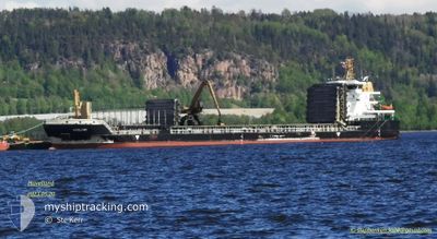
HAVELLAND
Cargo
Current Trip
| Time Travelled | 2 days |
|---|---|
| Remaining Time | 3 days |
| Distance Travelled | 599.44 nm |
| Remaining Distance | 767.95 nm |
| AVG Speed | 10.3 Knop |
| MAX Speed | 11.9 Knop |
| AVG Wind | 9.4 knots |
| MAX Wind | 19.8 knots |
| MIN Temp | -0.5°C / 31.1°F |
| MAX Temp | 8.7°C / 47.66°F |
| Djupgående | 6.4 m |
| Position mottagen | Nu |
Current Position
| Longitud | 16.15087° |
|---|---|
| Latitude | 55.95402° |
| Status | Under way using engine |
| Fart | 10.4 Knop |
| Kurs | 238.2° |
| Område | Baltic Sea |
| Station | T-AIS |
| Position mottagen | Nu |
Info
Information
The current position of HAVELLAND is in Baltic Sea with coordinates 55.95402° / 16.15087° as reported on 2024-04-29 00:25 by AIS to our vessel tracker app. The vessel's current speed is 10.4 Knop and is heading at the port of HULL. The estimated time of arrival as calculated by MyShipTracking vessel tracking app is 2024-05-02 03:18 LT
The vessel HAVELLAND (IMO: 9499735, MMSI: 255805653) is a Cargo It's sailing under the flag of [PT] Portugal.
In this page you can find informations about the vessels current position, last detected port calls, and current voyage information. If the vessels is not in coverage by AIS you will find the latest position.
The current position of HAVELLAND is detected by our AIS receivers and we are not responsible for the reliability of the data. The last position was recorded while the vessel was in Coverage by the Ais receivers of our vessel tracking app.
The current draught of HAVELLAND as reported by AIS is 6.4 meters
Weather
| Temperature | 8.5°C / 47.3°F |
|---|---|
| Wind Speed | 15 knots |
| Direction | 160° SSE |
| Pressure | 1016.6 hPa |
| Humidity | 82.6 % |
| Cloud Coverage | 100 % |
Featured Company
Last Port Calls
| Port | Arrival | Departure | Time In Port |
|---|---|---|---|
| 2024-04-24 13:44 | 2024-04-26 14:20 | 2 d | |
| 2024-04-22 08:05 | 2024-04-23 05:24 | 21 h | |
| 2024-04-17 22:50 | 2024-04-19 00:18 | 1 d | |
| 2024-04-16 19:45 | 2024-04-17 17:05 | 21 h | |
| 2024-04-10 18:17 | 2024-04-14 13:19 | 3 d | |
| 2024-04-01 11:59 | 2024-04-04 01:20 | 2 d | |
| 2024-03-30 05:14 | 2024-03-31 12:13 | 1 d | |
| 2024-03-27 16:49 | 2024-03-28 11:37 | 18 h | |
| 2024-03-23 04:13 | 2024-03-25 15:13 | 2 d | |
| 2024-03-18 06:52 | 2024-03-19 05:35 | 22 h |
Last Trips
| Origin | Departure | Destination | Arrival | Distance | |
|---|---|---|---|---|---|
| 2024-04-23 08:24 | 2024-04-24 16:44 | 252.45 nm | |||
| 2024-04-19 02:18 | 2024-04-22 11:05 | 803.90 nm | |||
| 2024-04-17 19:05 | 2024-04-18 00:50 | 65.85 nm | |||
| 2024-04-14 14:19 | 2024-04-16 21:45 | 552.31 nm | |||
| 2024-04-04 04:20 | 2024-04-10 19:17 | 1258.54 nm | |||
| 2024-03-31 15:13 | 2024-04-01 14:59 | 246.81 nm | |||
| 2024-03-28 13:37 | 2024-03-30 07:14 | 291.56 nm | |||
| 2024-03-25 16:13 | 2024-03-27 18:49 | 515.04 nm | |||
| 2024-03-19 07:35 | 2024-03-23 05:13 | 586.14 nm | |||
| 2024-03-11 17:42 | 2024-03-18 08:52 | 1128.78 nm |
Events
| Tid | Event | Detaljer | Position / Dest | Information |
|---|---|---|---|---|
| 2024-04-29 00:22 | STARTAR förflyttning | 19.68 nm, South East of EKENABBEN |
55.95746 / 16.16125
GBHUL
|
Fart: 10.2 kn Kurs: 240.6° |
| 2024-04-29 00:22 | STOPPAR förflyttning | 19.74 nm, South East of EKENABBEN |
55.95855 / 16.16419
GBHUL
|
Fart: Kurs: 238° |
| 2024-04-28 21:03 | Status ändrad | Under way using engine Default |
56.32892 / 16.86593
GBHUL
|
Fart: 9.9 kn Kurs: 202° |
| 2024-04-28 20:32 | Status ändrad | Default Under way using engine |
56.40826 / 16.92240
GBHUL
|
Fart: 9.9 kn Kurs: 201.3° |
| 2024-04-28 20:02 | Status ändrad | Under way using engine Default |
56.48594 / 16.97630
GBHUL
|
Fart: 10 kn Kurs: 200° |
| 2024-04-28 19:55 | Status ändrad | Default Under way using engine |
56.50525 / 16.98935
GBHUL
|
Fart: 9.9 kn Kurs: 200.5° |
| 2024-04-28 19:53 | Status ändrad | Under way using engine Default |
56.50989 / 16.99253
GBHUL
|
Fart: 9.9 kn Kurs: 200° |
| 2024-04-28 19:46 | Status ändrad | Default Under way using engine |
56.52640 / 17.00341
GBHUL
|
Fart: 9.9 kn Kurs: 199.3° |
| 2024-04-28 19:45 | Status ändrad | Under way using engine Default |
56.53114 / 17.00657
GBHUL
|
Fart: 9.9 kn Kurs: 200° |
| 2024-04-28 19:32 | I täckningsområde |
56.53114 / 17.00657
Baltic Sea
GBHUL
|
Fart: 9.9 kn Kurs: 199.3° |