

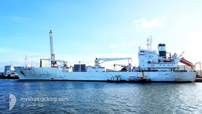
GREEN HONDURAS
Cargo

Current Trip
| Time Travelled | 1 day |
|---|---|
| Remaining Time | 1 day |
| Distance Travelled | 598.33 nm |
| Remaining Distance | 560.00 nm |
| AVG Speed | 16.3 Knop |
| MAX Speed | 17.6 Knop |
| AVG Wind | 13.2 knots |
| MAX Wind | 17 knots |
| MIN Temp | 24.2°C / 75.56°F |
| MAX Temp | 27.1°C / 80.78°F |
| Djupgående | 7.1 m |
| Position mottagen | 3 d sen |
Current Position
| Longitud | --- |
|---|---|
| Latitude | --- |
| Status | Under way using engine |
| Fart | 16.4 Knop |
| Kurs | 277.6° |
| Område | Caribbean Sea |
| Station | T-AIS |
| Position mottagen | 3 d sen |
Information
The current position of GREEN HONDURAS is in Caribbean Sea with coordinates 9.64455° / -80.27712° as reported on 2025-02-18 14:10 by AIS to our vessel tracker app. The vessel's current speed is 16.4 Knop and is heading at the port of CRISTOBAL. The estimated time of arrival as calculated by MyShipTracking vessel tracking app is 2025-02-23 00:34 LT
The vessel GREEN HONDURAS (IMO: 891213200, MMSI: 311289000) is a Cargo It's sailing under the flag of [BS] Bahamas.
In this page you can find informations about the vessels current position, last detected port calls, and current voyage information. If the vessels is not in coverage by AIS you will find the latest position.
The current position of GREEN HONDURAS is detected by our AIS receivers and we are not responsible for the reliability of the data. The last position was recorded while the vessel was in Coverage by the Ais receivers of our vessel tracking app.
The current draught of GREEN HONDURAS as reported by AIS is 7.1 meters
Weather
| Temperature | 25.7°C / 78.26°F |
|---|---|
| Wind Speed | 18 knots |
| Direction | 50° NE |
| Pressure | 1017.1 hPa |
| Humidity | 78 % |
| Cloud Coverage | 94 % |


Featured Company
Last Port Calls
| Port | Arrival | Departure | Time In Port |
|---|---|---|---|
| 2025-02-19 04:11 | 2025-02-20 06:38 | 1 d | |
| 2025-02-13 11:00 | 2025-02-14 15:36 | 1 d | |
| 2025-02-09 22:59 | 2025-02-11 01:58 | 1 d | |
| 2025-02-05 20:04 | 2025-02-07 14:51 | 1 d | |
| 2025-01-30 12:55 | 2025-01-31 19:19 | 1 d | |
| 2025-01-20 09:02 | 2025-01-20 09:13 | 10 m | |
| 2025-01-12 12:16 | 2025-01-13 07:40 | 19 h | |
| 2025-01-08 00:17 | 2025-01-11 00:30 | 3 d | |
| 2024-12-11 16:05 | 2024-12-20 20:20 | 9 d | |
| 2024-12-02 21:12 | 2024-12-03 17:26 | 20 h |
Most Visited Ports (Last year)
| Port | Arrivals | |
|---|---|---|
| 5 | ||
| 3 | ||
| 3 | ||
| 3 | ||
| 3 | ||
| 2 |
Last Trips
| Origin | Departure | Destination | Arrival | Distance | |
|---|---|---|---|---|---|
| 2025-02-14 10:36 | 2025-02-18 22:11 | 1407.77 nm | |||
| 2025-02-10 19:58 | 2025-02-13 06:00 | 854.11 nm | |||
| 2025-02-07 09:51 | 2025-02-09 16:59 | 822.39 nm | |||
| 2025-01-31 13:19 | 2025-02-05 15:04 | 1232.10 nm | |||
| 2025-01-20 04:13 | 2025-01-30 06:55 | 2111.42 nm | |||
| 2025-01-13 01:40 | 2025-01-20 04:02 | 2105.44 nm | |||
| 2025-01-10 19:30 | 2025-01-12 06:16 | 429.51 nm | |||
| 2024-12-20 21:20 | 2025-01-07 19:17 | 5589.64 nm | |||
| 2024-12-03 17:26 | 2024-12-11 17:05 | 2525.00 nm | |||
| 2024-11-26 23:51 | 2024-12-02 21:12 | 1804.02 nm |
Events
| Tid | Event | Detaljer | Position / Dest | Information |
|---|---|---|---|---|
| 2025-02-20 06:38 | AVGÅTT HAMN |
|
10.01697 / -83.08450
PACTB
|
Fart: 5.9 kn Kurs: 326° |
| 2025-02-20 06:35 | STARTAR förflyttning |
10.01186 / -83.08125
[CR] MOIN
|
Fart: 5.9 kn Kurs: 326° |
|
| 2025-02-19 04:22 | STOPPAR förflyttning |
10.00616 / -83.07716
[CR] MOIN
|
Fart: Kurs: 6° |
|
| 2025-02-19 04:11 | ANLÄNDER HAMN |
|
10.00677 / -83.07835
[CR] MOIN
|
Fart: 2 kn Kurs: 145° |
| 2025-02-18 14:13 | Status ändrad | Default Under way using engine |
9.64661 / -80.28775
PACTB
|
Fart: 16.4 kn Kurs: 277.6° |
| 2025-02-18 14:10 | UTANFÖR täckningsområde |
9.64455 / -80.27712
Caribbean Sea
|
Fart: 16.4 kn Kurs: 277.6° |
|
| 2025-02-18 13:57 | Status ändrad | Under way using engine Default |
9.63242 / -80.21468
PACTB
|
Fart: 16 kn Kurs: 283° |
| 2025-02-18 13:43 | Status ändrad | Default Under way using engine |
9.62102 / -80.15398
PACTB
|
Fart: 16.2 kn Kurs: 279° |
| 2025-02-18 12:56 | Status ändrad | Under way using engine Default |
9.55669 / -79.95544
PACTB
|
Fart: 16.4 kn Kurs: 304° |
| 2025-02-18 12:55 | Status ändrad | Default Under way using engine |
9.55419 / -79.95220
PACTB
|
Fart: 16.2 kn Kurs: 305.2° |