
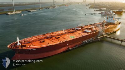
GREAT LADY
Crude Oil Tanker
Current Trip
| Time Travelled | 17 days |
|---|---|
| Remaining Time | --- |
| Distance Travelled | 4324.20 nm |
| Remaining Distance | 941.68 nm |
| AVG Speed | 13.5 Knop |
| MAX Speed | 17.4 Knop |
| AVG Wind | 14.4 knots |
| MAX Wind | 27 knots |
| MIN Temp | 8.3°C / 46.94°F |
| MAX Temp | 28.1°C / 82.58°F |
| Djupgående | 18.8 m |
| Position mottagen | 9 d sen |
Current Position
| Longitud | -77.46544° |
|---|---|
| Latitude | 27.93374° |
| Status | Under way using engine |
| Fart | 13.9 Knop |
| Kurs | 74.3° |
| Område | North Atlantic Ocean |
| Station | T-AIS |
| Position mottagen | 9 d sen |
Info
Information
The current position of GREAT LADY is in North Atlantic Ocean with coordinates 27.93374° / -77.46544° as reported on 2024-05-11 17:46 by AIS to our vessel tracker app. The vessel's current speed is 13.9 Knop and is heading at the port of ROTTERDAM. The estimated time of arrival as calculated by MyShipTracking vessel tracking app is 2024-05-23 19:00 LT
The vessel GREAT LADY (IMO: 9286138, MMSI: 636022378) is a Crude Oil Tanker that was built in 2005 ( 19 År gammal ). It's sailing under the flag of [LR] Liberia.
In this page you can find informations about the vessels current position, last detected port calls, and current voyage information. If the vessels is not in coverage by AIS you will find the latest position.
The current position of GREAT LADY is detected by our AIS receivers and we are not responsible for the reliability of the data. The last position was recorded while the vessel was in Coverage by the Ais receivers of our vessel tracking app.
The current draught of GREAT LADY as reported by AIS is 18.8 meters
Weather
| Temperature | 12.3°C / 54.14°F |
|---|---|
| Wind Speed | 16 knots |
| Direction | 288° WNW |
| Pressure | 1010.5 hPa |
| Humidity | 91.6 % |
| Cloud Coverage | 100 % |
Featured Company
Most Visited Ports (Last year)
| Port | Arrivals | |
|---|---|---|
| 3 | ||
| 2 | ||
| 1 | ||
| 1 | ||
| 1 |
Last Trips
| Origin | Departure | Destination | Arrival | Distance |
|---|
Events
| Tid | Event | Detaljer | Position / Dest | Information |
|---|---|---|---|---|
| 2024-05-11 17:51 | Status ändrad | Default Under way using engine |
27.93833 / -77.44500
NL RTM
|
Fart: 13.9 kn Kurs: 74.3° |
| 2024-05-11 17:46 | UTANFÖR täckningsområde |
27.93374 / -77.46544
North Atlantic Ocean
NL RTM
|
Fart: 13.9 kn Kurs: 74.3° |
|
| 2024-05-11 17:43 | Status ändrad | Under way using engine Default |
27.92998 / -77.48059
NL RTM
|
Fart: 14 kn Kurs: 74° |
| 2024-05-11 17:30 | I täckningsområde |
27.92998 / -77.48059
North Atlantic Ocean
NL RTM
|
Fart: 13.9 kn Kurs: 74.2° |
|
| 2024-05-11 16:42 | Status ändrad | Default Under way using engine |
27.86500 / -77.74333
NL RTM
|
Fart: 14.8 kn Kurs: 74.5° |
| 2024-05-11 16:37 | UTANFÖR täckningsområde |
27.86008 / -77.76591
North Atlantic Ocean
NL RTM
|
Fart: 14.8 kn Kurs: 74.5° |
|
| 2024-05-11 15:57 | Status ändrad | Under way using engine Default |
27.81581 / -77.94372
NL RTM
|
Fart: 14 kn Kurs: 74° |
| 2024-05-11 15:54 | Status ändrad | Default Under way using engine |
27.81167 / -77.95500
NL RTM
|
Fart: 14.5 kn Kurs: 75.3° |
| 2024-05-11 13:40 | Status ändrad | Under way using engine Default |
27.67122 / -78.55379
NL RTM
|
Fart: 14 kn Kurs: 73° |
| 2024-05-11 13:36 | Status ändrad | Default Under way using engine |
27.66500 / -78.57166
NL RTM
|
Fart: 14.9 kn Kurs: 73.7° |