
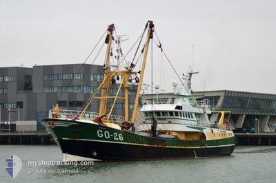
GO26 ARENDJAN
Trawler
Current Trip
FISHING GROUNDS
| Time Travelled | 2 days |
|---|---|
| Remaining Time | --- |
| Distance Travelled | 101.99 nm |
| Remaining Distance | --- |
| AVG Speed | 7 Knop |
| MAX Speed | 10.2 Knop |
| AVG Wind | 12.7 knots |
| MAX Wind | 16.8 knots |
| MIN Temp | 10.1°C / 50.18°F |
| MAX Temp | 12.2°C / 53.96°F |
| Djupgående | 5 m |
| Position mottagen | 18 h, 26 m sen |
Current Position
| Longitud | 2.91294° |
|---|---|
| Latitude | 52.26071° |
| Status | Under way sailing |
| Fart | 0.7 Knop |
| Kurs | --- |
| Område | North Sea |
| Station | T-AIS |
| Position mottagen | 18 h, 26 m sen |
Info
Information
The current position of GO26 ARENDJAN is in North Sea with coordinates 52.26071° / 2.91294° as reported on 2024-04-30 11:07 by AIS to our vessel tracker app. The vessel's current speed is 0.7 Knop
The vessel GO26 ARENDJAN (IMO: 9242742, MMSI: 245252000) is a Trawler that was built in 2002 ( 22 År gammal ). It's sailing under the flag of [NL] Netherlands.
In this page you can find informations about the vessels current position, last detected port calls, and current voyage information. If the vessels is not in coverage by AIS you will find the latest position.
The current position of GO26 ARENDJAN is detected by our AIS receivers and we are not responsible for the reliability of the data. The last position was recorded while the vessel was in Coverage by the Ais receivers of our vessel tracking app.
The current draught of GO26 ARENDJAN as reported by AIS is 5 meters
Weather
| Temperature | 11.4°C / 52.52°F |
|---|---|
| Wind Speed | 10 knots |
| Direction | 156° SSE |
| Pressure | 1014.2 hPa |
| Humidity | 93.1 % |
| Cloud Coverage | 84 % |
Featured Company
Last Port Calls
| Port | Arrival | Departure | Time In Port |
|---|---|---|---|
| 2024-04-26 03:57 | 2024-04-28 23:20 | 2 d | |
| 2024-04-22 00:38 | 2024-04-23 00:14 | 23 h | |
| 2024-04-12 03:14 | 2024-04-22 00:17 | 9 d | |
| 2024-04-04 13:16 | 2024-04-07 22:58 | 3 d | |
| 2024-03-29 02:29 | 2024-04-01 22:44 | 3 d | |
| 2024-03-21 10:13 | 2024-03-24 23:54 | 3 d | |
| 2024-03-15 02:26 | 2024-03-18 00:01 | 2 d | |
| 2024-03-08 02:47 | 2024-03-10 23:45 | 2 d | |
| 2024-03-01 03:19 | 2024-03-03 23:55 | 2 d |
Most Visited Ports (Last year)
| Port | Arrivals | |
|---|---|---|
| 47 | ||
| 2 | ||
| 1 |
Last Trips
| Origin | Departure | Destination | Arrival | Distance | |
|---|---|---|---|---|---|
| 2024-04-23 02:14 | 2024-04-26 05:57 | 150.73 nm | |||
| 2024-04-22 02:17 | 2024-04-22 02:38 | 1.78 nm | |||
| 2024-04-08 00:58 | 2024-04-12 05:14 | 225.23 nm | |||
| 2024-04-02 00:44 | 2024-04-04 15:16 | 129.41 nm | |||
| 2024-03-25 00:54 | 2024-03-29 03:29 | 148.25 nm | |||
| 2024-03-18 01:01 | 2024-03-21 11:13 | 242.17 nm | |||
| 2024-03-11 00:45 | 2024-03-15 03:26 | 200.69 nm | |||
| 2024-03-04 00:55 | 2024-03-08 03:47 | 226.63 nm | |||
| 2024-02-26 00:45 | 2024-03-01 04:19 | 152.08 nm |
Events
| Tid | Event | Detaljer | Position / Dest | Information |
|---|---|---|---|---|
| 2024-04-30 11:07 | UTANFÖR täckningsområde |
52.26071 / 2.91294
North Sea
|
Fart: 0.7 kn Kurs: 217.1° |
|
| 2024-04-30 10:38 | Upptäckt i hav | Dutch part of the North Sea |
52.24463 / 2.97329
North Sea
|
Fart: 5.6 kn Kurs: 286.2° |
| 2024-04-30 10:38 | I täckningsområde |
52.24463 / 2.97329
North Sea
|
Fart: 5.6 kn Kurs: 286.2° |
|
| 2024-04-30 09:27 | UTANFÖR täckningsområde |
52.26935 / 2.85960
North Sea
|
Fart: 5.6 kn Kurs: 107.5° |
|
| 2024-04-30 08:10 | Upptäckt i hav | United Kingdom part of the North Sea |
52.24815 / 2.86170
North Sea
|
Fart: 5.9 kn Kurs: 296.1° |
| 2024-04-30 03:49 | I täckningsområde |
52.27126 / 3.05930
North Sea
|
Fart: 5.1 kn Kurs: 205.5° |
|
| 2024-04-30 01:13 | UTANFÖR täckningsområde |
52.19070 / 2.99886
North Sea
|
Fart: 5.7 kn Kurs: 323.7° |
|
| 2024-04-30 01:13 | I täckningsområde |
52.19070 / 2.99886
North Sea
|
Fart: 5.7 kn Kurs: 323.7° |
|
| 2024-04-29 02:20 | UTANFÖR täckningsområde |
52.51503 / 3.86089
North Sea
|
Fart: 6 kn Kurs: 274.8° |
|
| 2024-04-28 23:20 | AVGÅTT HAMN |
|
52.46404 / 4.56296
FISHING GROUNDS
|
Fart: 10 kn Kurs: 277.1° |