
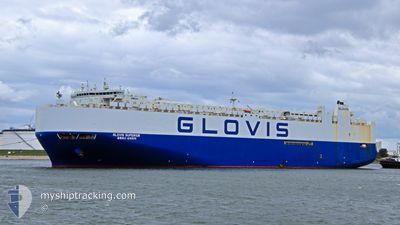
GLOVIS SUPERIOR
Vehicles Carrier
Current Trip
| Time Travelled | 6 days |
|---|---|
| Remaining Time | --- |
| Distance Travelled | 2496.26 nm |
| Remaining Distance | --- |
| AVG Speed | 15.5 Knop |
| MAX Speed | 19.7 Knop |
| AVG Wind | 14.2 knots |
| MAX Wind | 31.6 knots |
| MIN Temp | 12.9°C / 55.22°F |
| MAX Temp | 23.4°C / 74.12°F |
| Djupgående | 9.5 m |
| Position mottagen | 2 d sen |
Current Position
| Longitud | -15.21963° |
|---|---|
| Latitude | 27.59997° |
| Status | Under way using engine |
| Fart | 17.3 Knop |
| Kurs | 200.6° |
| Område | North Atlantic Ocean |
| Station | T-AIS |
| Position mottagen | 2 d sen |
Info
Information
The current position of GLOVIS SUPERIOR is in North Atlantic Ocean with coordinates 27.59997° / -15.21963° as reported on 2024-06-04 20:24 by AIS to our vessel tracker app. The vessel's current speed is 17.3 Knop and is heading at the port of SINGAPORE. The estimated time of arrival as calculated by MyShipTracking vessel tracking app is 2024-07-01 12:00 LT
The vessel GLOVIS SUPERIOR (IMO: 9674189, MMSI: 441156000) is a Vehicles Carrier that was built in 2013 ( 11 År gammal ). It's sailing under the flag of [KR] Korea.
In this page you can find informations about the vessels current position, last detected port calls, and current voyage information. If the vessels is not in coverage by AIS you will find the latest position.
The current position of GLOVIS SUPERIOR is detected by our AIS receivers and we are not responsible for the reliability of the data. The last position was recorded while the vessel was in Coverage by the Ais receivers of our vessel tracking app.
The current draught of GLOVIS SUPERIOR as reported by AIS is 9.5 meters
Weather
| Temperature | 23.4°C / 74.12°F |
|---|---|
| Wind Speed | 9 knots |
| Direction | 353° N |
| Pressure | 1014.5 hPa |
| Humidity | 79.4 % |
| Cloud Coverage | 17 % |
Featured Company
Last Port Calls
| Port | Arrival | Departure | Time In Port |
|---|---|---|---|
| 2024-05-30 23:53 | 2024-05-31 19:19 | 19 h | |
| 2024-05-25 10:29 | 2024-05-29 16:22 | 4 d | |
| 2024-05-18 00:13 | 2024-05-18 20:27 | 20 h | |
| 2024-05-09 14:10 | 2024-05-09 22:30 | 8 h | |
| 2024-04-27 06:54 | 2024-04-27 17:22 | 10 h | |
| 2024-04-24 07:29 | 2024-04-26 07:39 | 2 d | |
| 2024-04-20 21:07 | 2024-04-22 15:07 | 1 d | |
| 2024-04-17 05:33 | 2024-04-17 20:40 | 15 h | |
| 2024-04-11 20:54 | 2024-04-12 07:14 | 10 h | |
| 2024-04-08 08:35 | 2024-04-09 06:13 | 21 h |
Most Visited Ports (Last year)
| Port | Arrivals | |
|---|---|---|
| 4 | ||
| 3 | ||
| 3 | ||
| 3 | ||
| 3 | ||
| 2 |
Last Trips
| Origin | Departure | Destination | Arrival | Distance | |
|---|---|---|---|---|---|
| 2024-05-29 16:22 | 2024-05-30 23:53 | 467.64 nm | |||
| 2024-05-18 20:27 | 2024-05-25 10:29 | 398.96 nm | |||
| 2024-05-09 22:30 | 2024-05-18 00:13 | 2591.76 nm | |||
| 2024-04-27 17:22 | 2024-05-09 14:10 | 4230.66 nm | |||
| 2024-04-26 07:39 | 2024-04-27 06:54 | 280.53 nm | |||
| 2024-04-22 15:07 | 2024-04-24 07:29 | 420.66 nm | |||
| 2024-04-17 20:40 | 2024-04-20 21:07 | 1160.03 nm | |||
| 2024-04-12 07:14 | 2024-04-17 05:33 | 1920.70 nm | |||
| 2024-04-09 06:13 | 2024-04-11 20:54 | 1056.25 nm | |||
| 2024-04-05 20:56 | 2024-04-08 08:35 | 481.24 nm |
Events
| Tid | Event | Detaljer | Position / Dest | Information |
|---|---|---|---|---|
| 2024-06-04 20:30 | Status ändrad | Default Under way using engine |
27.57471 / -15.23024
SG SIN
|
Fart: 17.3 kn Kurs: 200.6° |
| 2024-06-04 20:24 | UTANFÖR täckningsområde |
27.59997 / -15.21963
North Atlantic Ocean
SG SIN
|
Fart: 17.3 kn Kurs: 200.6° |
|
| 2024-06-04 15:58 | Status ändrad | Under way using engine Default |
28.77909 / -14.80190
SG SIN
|
Fart: 16.2 kn Kurs: 193° |
| 2024-06-04 15:54 | Status ändrad | Default Under way using engine |
28.79664 / -14.79716
SG SIN
|
Fart: 16.3 kn Kurs: 193.2° |
| 2024-06-04 15:47 | Status ändrad | Under way using engine Default |
28.82406 / -14.79039
SG SIN
|
Fart: 16.4 kn Kurs: 192° |
| 2024-06-04 15:46 | Status ändrad | Default Under way using engine |
28.83248 / -14.78830
SG SIN
|
Fart: 16.2 kn Kurs: 193° |
| 2024-06-04 15:41 | Status ändrad | Under way using engine Default |
28.85279 / -14.78329
SG SIN
|
Fart: 16.2 kn Kurs: 194° |
| 2024-06-04 15:33 | I täckningsområde |
28.85279 / -14.78329
North Atlantic Ocean
SG SIN
|
Fart: 16.2 kn Kurs: 193° |
|
| 2024-06-04 12:16 | Status ändrad | Default Under way using engine |
29.75038 / -14.47016
SG SIN
|
Fart: 16.7 kn Kurs: 196.4° |
| 2024-06-04 12:11 | UTANFÖR täckningsområde |
29.77181 / -14.46341
North Atlantic Ocean
SG SIN
|
Fart: 16.7 kn Kurs: 196.4° |