
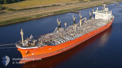
GINGA TIGER
Oil/Chemical Tanker
Current Trip
| Time Travelled | 9 days |
|---|---|
| Remaining Time | --- |
| Distance Travelled | 2385.88 nm |
| Remaining Distance | --- |
| AVG Speed | 11.9 Knop |
| MAX Speed | 14.2 Knop |
| AVG Wind | 9.3 knots |
| MAX Wind | 19 knots |
| MIN Temp | 14°C / 57.2°F |
| MAX Temp | 27.3°C / 81.14°F |
| Djupgående | 10.2 m |
| Position mottagen | 3 d sen |
Current Position
| Longitud | --- |
|---|---|
| Latitude | --- |
| Status | Under way using engine |
| Fart | 12.8 Knop |
| Kurs | 182° |
| Område | North Atlantic Ocean |
| Station | T-AIS |
| Position mottagen | 3 d sen |
Info
Information
The current position of GINGA TIGER is in North Atlantic Ocean with coordinates 14.16920° / -18.56937° as reported on 2025-12-31 21:25 by AIS to our vessel tracker app. The vessel's current speed is 12.8 Knop and is heading at the port of NACALA PORTO. The estimated time of arrival as calculated by MyShipTracking vessel tracking app is 2026-01-20 07:00 LT
The vessel GINGA TIGER (IMO: 9278715, MMSI: 353491000) is a Oil/Chemical Tanker that was built in 2003 ( 23 År gammal ). It's sailing under the flag of [PA] Panama.
In this page you can find informations about the vessels current position, last detected port calls, and current voyage information. If the vessels is not in coverage by AIS you will find the latest position.
The current position of GINGA TIGER is detected by our AIS receivers and we are not responsible for the reliability of the data. The last position was recorded while the vessel was in Coverage by the Ais receivers of our vessel tracking app.
The current draught of GINGA TIGER as reported by AIS is 10.2 meters
Weather
| Temperature | 25.7°C / 78.26°F |
|---|---|
| Wind Speed | 13 knots |
| Direction | 148° SSE |
| Pressure | 1013.5 hPa |
| Humidity | 82.1 % |
| Cloud Coverage | 91 % |
Featured Company
Last Port Calls
| Port | Arrival | Departure | Time In Port |
|---|---|---|---|
| 2025-12-23 11:41 | 2025-12-26 04:16 | 2 d | |
| 2025-12-09 09:34 | 2025-12-11 03:46 | 1 d | |
| 2025-12-07 16:43 | 2025-12-08 17:11 | 1 d | |
| 2025-12-06 15:16 | 2025-12-07 11:05 | 19 h | |
| 2025-12-02 07:00 | 2025-12-02 20:45 | 13 h |
Most Visited Ports (Last year)
| Port | Arrivals | |
|---|---|---|
| 6 | ||
| 5 | ||
| 4 | ||
| 2 | ||
| 2 | ||
| 2 |
Last Trips
| Origin | Departure | Destination | Arrival | Distance | |
|---|---|---|---|---|---|
| 2025-12-11 03:46 | 2025-12-23 11:41 | 2204.07 nm | |||
| 2025-12-08 17:11 | 2025-12-09 09:34 | 15.24 nm | |||
| 2025-12-07 11:05 | 2025-12-07 16:43 | 19.13 nm | |||
| 2025-12-02 20:45 | 2025-12-06 15:16 | 932.09 nm | |||
| 2025-10-15 04:39 | 2025-12-02 07:00 | 8303.99 nm |
Events
| Tid | Event | Detaljer | Position / Dest | Information |
|---|---|---|---|---|
| 2025-12-31 21:27 | Status ändrad | Default Under way using engine |
14.16508 / -18.56955
MZ MNC
|
Fart: 12.8 kn Kurs: 182° |
| 2025-12-31 21:25 | Status ändrad | Under way using engine Default |
14.16920 / -18.56937
MZ MNC
|
Fart: 12.7 kn Kurs: 182° |
| 2025-12-31 21:25 | UTANFÖR täckningsområde |
14.16920 / -18.56937
North Atlantic Ocean
MZ MNC
|
Fart: 12.8 kn Kurs: 182° |
|
| 2025-12-31 21:02 | Status ändrad | Default Under way using engine |
14.25383 / -18.56680
MZ MNC
|
Fart: 12.8 kn Kurs: 181° |
| 2025-12-31 20:55 | Status ändrad | Under way using engine Default |
14.27750 / -18.56648
MZ MNC
|
Fart: 12.8 kn Kurs: 182° |
| 2025-12-31 20:52 | Status ändrad | Default Under way using engine |
14.28998 / -18.56610
MZ MNC
|
Fart: 12.8 kn Kurs: 179° |
| 2025-12-31 19:25 | Status ändrad | Under way using engine Default |
14.60060 / -18.56452
MZ MNC
|
Fart: 12.8 kn Kurs: 180° |
| 2025-12-31 19:15 | Status ändrad | Default Under way using engine |
14.63655 / -18.56335
MZ MNC
|
Fart: 13.1 kn Kurs: 186° |
| 2025-12-31 19:07 | Status ändrad | Under way using engine Default |
14.66373 / -18.56148
MZ MNC
|
Fart: 13 kn Kurs: 184° |
| 2025-12-31 18:59 | Status ändrad | Default Under way using engine |
14.69367 / -18.55957
MZ MNC
|
Fart: 12.8 kn Kurs: 182° |