
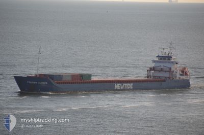
FRISIAN SUMMER
General Cargo
Current Trip
| Time Travelled | 5 days |
|---|---|
| Remaining Time | --- |
| Distance Travelled | 1239.33 nm |
| Remaining Distance | --- |
| AVG Speed | 9.1 Knop |
| MAX Speed | 13.8 Knop |
| AVG Wind | 12.5 knots |
| MAX Wind | 32 knots |
| MIN Temp | 0.6°C / 33.08°F |
| MAX Temp | 21.6°C / 70.88°F |
| Djupgående | 5.9 m |
| Position mottagen | Nu |
Current Position
| Longitud | 14.33243° |
|---|---|
| Latitude | 55.16914° |
| Status | Under way using engine |
| Fart | 10.2 Knop |
| Kurs | 42.1° |
| Område | Kattegat |
| Station | T-AIS |
| Position mottagen | Nu |
Info
Information
The current position of FRISIAN SUMMER is in Kattegat with coordinates 55.16914° / 14.33243° as reported on 2024-04-26 05:28 by AIS to our vessel tracker app. The vessel's current speed is 10.2 Knop and is heading at the port of PARGAS. The estimated time of arrival as calculated by MyShipTracking vessel tracking app is 2024-04-28 12:00 LT
The vessel FRISIAN SUMMER (IMO: 9367762, MMSI: 245147000) is a General Cargo that was built in 2008 ( 16 År gammal ). It's sailing under the flag of [NL] Netherlands.
In this page you can find informations about the vessels current position, last detected port calls, and current voyage information. If the vessels is not in coverage by AIS you will find the latest position.
The current position of FRISIAN SUMMER is detected by our AIS receivers and we are not responsible for the reliability of the data. The last position was recorded while the vessel was in Coverage by the Ais receivers of our vessel tracking app.
The current draught of FRISIAN SUMMER as reported by AIS is 5.9 meters
Weather
| Temperature | 5.2°C / 41.36°F |
|---|---|
| Wind Speed | 14 knots |
| Direction | 104° ESE |
| Pressure | 1006.3 hPa |
| Humidity | 86.7 % |
| Cloud Coverage | 100 % |
Featured Company
Last Port Calls
| Port | Arrival | Departure | Time In Port |
|---|---|---|---|
| 2024-04-20 03:14 | 2024-04-20 15:40 | 12 h | |
| 2024-04-06 03:47 | 2024-04-06 19:08 | 15 h | |
| 2024-03-24 01:45 | 2024-03-28 15:33 | 4 d | |
| 2024-03-07 15:46 | 2024-03-10 14:02 | 2 d | |
| 2024-02-28 08:40 | 2024-03-03 17:27 | 4 d | |
| 2024-02-25 06:20 | 2024-02-27 02:41 | 1 d | |
| 2024-02-25 05:14 | 2024-02-25 05:25 | 11 m | |
| 2024-02-18 16:44 | 2024-02-19 19:14 | 1 d | |
| 2024-02-11 07:24 | 2024-02-17 09:09 | 6 d | |
| 2024-02-02 22:28 | 2024-02-04 08:28 | 1 d |
Last Trips
| Origin | Departure | Destination | Arrival | Distance | |
|---|---|---|---|---|---|
| 2024-04-06 22:08 | 2024-04-20 05:14 | 1949.04 nm | |||
| 2024-03-28 16:33 | 2024-04-06 06:47 | 1619.44 nm | |||
| 2024-03-10 15:02 | 2024-03-24 02:45 | 2181.42 nm | |||
| 2024-03-03 17:27 | 2024-03-07 16:46 | 862.83 nm | |||
| 2024-02-27 03:41 | 2024-02-28 08:40 | 288.52 nm | |||
| 2024-02-25 06:25 | 2024-02-25 07:20 | 7.18 nm | |||
| 2024-02-19 21:14 | 2024-02-25 06:14 | 1126.66 nm | |||
| 2024-02-17 10:09 | 2024-02-18 18:44 | 330.20 nm | |||
| 2024-02-04 08:28 | 2024-02-11 08:24 | 867.01 nm | |||
| 2024-02-01 19:49 | 2024-02-02 22:28 | 287.66 nm |
Events
| Tid | Event | Detaljer | Position / Dest | Information |
|---|---|---|---|---|
| 2024-04-26 04:16 | Upptäckt i hav | Danish part of the Kattegat |
55.02692 / 14.08548
Kattegat
PARAINEN
|
Fart: 9.9 kn Kurs: 65° |
| 2024-04-26 03:40 | Upptäckt i hav | Swedish part of the Baltic Sea |
54.98369 / 13.92810
Baltic Sea
PARAINEN
|
Fart: 10.1 kn Kurs: 65.4° |
| 2024-04-25 20:16 | Byter havsområde | German part of the Baltic Sea Danish part of the Baltic Sea |
54.41638 / 12.12216
Baltic Sea
PARAINEN
|
Fart: 9.2 kn Kurs: 82° |
| 2024-04-25 17:43 | Upptäckt i hav | Danish part of the Baltic Sea |
54.50421 / 11.43467
Baltic Sea
PARAINEN
|
Fart: 9.7 kn Kurs: 113.4° |
| 2024-04-25 15:14 | Byter havsområde | German part of the Baltic Sea Danish part of the Baltic Sea |
54.55624 / 10.76129
Baltic Sea
PARAINEN
|
Fart: 10.2 kn Kurs: 84.4° |
| 2024-04-25 14:50 | Byter havsområde | Danish part of the Baltic Sea German part of the Baltic Sea |
54.54919 / 10.64409
Baltic Sea
PARAINEN
|
Fart: 10.2 kn Kurs: 84° |
| 2024-04-25 13:26 | Byter havsområde | German part of the Baltic Sea German part of the North Sea |
54.46382 / 10.27981
Baltic Sea
PARAINEN
|
Fart: 9.9 kn Kurs: 38.5° |
| 2024-04-25 12:35 | STARTAR förflyttning | 1.34 nm, South West of STICKENHΟRN SPORT |
54.36605 / 10.14287
PARAINEN
|
Fart: 3.2 kn Kurs: 106° |
| 2024-04-25 11:38 | STOPPAR förflyttning | 1.7 nm, South West of STICKENHΟRN SPORT |
54.36845 / 10.12636
PARAINEN
|
Fart: 0.3 kn Kurs: 104° |
| 2024-04-25 10:07 | STARTAR förflyttning | 6.08 nm, East of BORGSTEDT |
54.35468 / 9.88573
PARAINEN
|
Fart: 4 kn Kurs: 115° |