
FLORIDA HIGHWAY
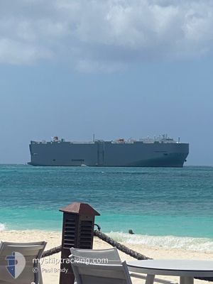
Vehicles Carrier
Current Trip
| Time Travelled | 1 day |
|---|---|
| Remaining Time | 22 h, 43 mins |
| Distance Travelled | 559.65 nm |
| Remaining Distance | 384.87 nm |
| AVG Speed | 14.2 Knop |
| MAX Speed | 17.9 Knop |
| AVG Wind | 8.9 knots |
| MAX Wind | 19.2 knots |
| MIN Temp | 19.5°C / 67.1°F |
| MAX Temp | 36.2°C / 97.16°F |
| Djupgående | 9.2 m |
| Position mottagen | 8 d sen |
Current Position
| Longitud | --- |
|---|---|
| Latitude | --- |
| Status | Under way using engine |
| Fart | 17.3 Knop |
| Kurs | 217° |
| Område | South Atlantic Ocean |
| Station | T-AIS |
| Position mottagen | 8 d sen |
Info
Information
The current position of FLORIDA HIGHWAY is in South Atlantic Ocean with coordinates -29.82813° / -48.69778° as reported on 2024-11-17 23:35 by AIS to our vessel tracker app. The vessel's current speed is 17.3 Knop and is heading at the port of MONTEVIDEO. The estimated time of arrival as calculated by MyShipTracking vessel tracking app is 2024-11-27 05:21 LT
The vessel FLORIDA HIGHWAY (IMO: 9442861, MMSI: 372805000) is a Vehicles Carrier that was built in 2008 ( 16 År gammal ). It's sailing under the flag of [PA] Panama.
In this page you can find informations about the vessels current position, last detected port calls, and current voyage information. If the vessels is not in coverage by AIS you will find the latest position.
The current position of FLORIDA HIGHWAY is detected by our AIS receivers and we are not responsible for the reliability of the data. The last position was recorded while the vessel was in Coverage by the Ais receivers of our vessel tracking app.
The current draught of FLORIDA HIGHWAY as reported by AIS is 9.2 meters
Weather
| Temperature | 21.8°C / 71.24°F |
|---|---|
| Wind Speed | 12 knots |
| Direction | 15° NNE |
| Pressure | 1010.8 hPa |
| Humidity | 93.1 % |
| Cloud Coverage | 98 % |
Featured Company
Last Port Calls
| Port | Arrival | Departure | Time In Port |
|---|---|---|---|
| 2024-11-21 03:33 | 2024-11-24 15:37 | 3 d | |
| 2024-11-19 10:41 | 2024-11-20 05:53 | 19 h | |
| 2024-11-16 02:40 | 2024-11-17 01:22 | 22 h | |
| 2024-11-10 11:11 | 2024-11-11 00:55 | 13 h | |
| 2024-11-08 19:42 | 2024-11-09 07:47 | 12 h | |
| 2024-11-05 08:23 | 2024-11-05 23:47 | 15 h | |
| 2024-10-27 17:25 | 2024-10-27 21:52 | 4 h | |
| 2024-10-15 14:35 | 2024-10-17 00:35 | 1 d | |
| 2024-10-12 01:23 | 2024-10-13 22:21 | 1 d | |
| 2024-10-01 13:02 | 2024-10-02 00:07 | 11 h |
Most Visited Ports (Last year)
| Port | Arrivals | |
|---|---|---|
| 14 | ||
| 9 | ||
| 8 | ||
| 8 | ||
| 8 | ||
| 7 |
Last Trips
| Origin | Departure | Destination | Arrival | Distance | |
|---|---|---|---|---|---|
| 2024-11-20 02:53 | 2024-11-21 00:33 | 198.69 nm | |||
| 2024-11-16 22:22 | 2024-11-19 07:41 | 902.05 nm | |||
| 2024-11-10 21:55 | 2024-11-15 23:40 | 420.48 nm | |||
| 2024-11-09 04:47 | 2024-11-10 08:11 | 392.62 nm | |||
| 2024-11-05 20:47 | 2024-11-08 16:42 | 1089.40 nm | |||
| 2024-10-27 16:52 | 2024-11-05 05:23 | 3000.71 nm | |||
| 2024-10-16 19:35 | 2024-10-27 12:25 | 2832.50 nm | |||
| 2024-10-13 17:21 | 2024-10-15 09:35 | 242.83 nm | |||
| 2024-10-01 20:07 | 2024-10-11 20:23 | 2444.01 nm | |||
| 2024-09-24 13:33 | 2024-10-01 09:02 | 2747.78 nm |
Events
| Tid | Event | Detaljer | Position / Dest | Information |
|---|---|---|---|---|
| 2024-11-25 00:05 | STARTAR förflyttning | 7.82 nm, North of LA PLATA |
-34.72802 / -57.82877
UYMVD
|
Fart: 4.4 kn Kurs: 60° |
| 2024-11-24 23:04 | STOPPAR förflyttning | 7.54 nm, North of LA PLATA |
-34.73122 / -57.83422
UYMVD
|
Fart: Kurs: 72° |
| 2024-11-24 15:37 | AVGÅTT HAMN |
|
-34.08558 / -59.01358
UYMVD
|
Fart: 9.1 kn Kurs: 140° |
| 2024-11-24 15:25 | STARTAR förflyttning |
-34.06468 / -59.03250
[AR] ZARATE
|
Fart: 3.4 kn Kurs: 148° |
|
| 2024-11-21 03:34 | STOPPAR förflyttning |
-34.06390 / -59.03472
[AR] ZARATE
|
Fart: 0.3 kn Kurs: 150° |
|
| 2024-11-21 03:33 | ANLÄNDER HAMN |
|
-34.06390 / -59.03472
[AR] ZARATE
|
Fart: 0.4 kn Kurs: 145° |
| 2024-11-20 11:01 | STARTAR förflyttning | 11.2 nm, South East of BUCEO |
-35.05707 / -55.99020
UYMVD
|
Fart: 3.3 kn Kurs: 82° |
| 2024-11-20 07:53 | STOPPAR förflyttning | 11.17 nm, South East of BUCEO |
-35.05870 / -55.99383
UYMVD
|
Fart: 0.2 kn Kurs: 66° |
| 2024-11-20 05:53 | AVGÅTT HAMN |
|
-34.91328 / -56.22493
UYMVD
|
Fart: 5.2 kn Kurs: 203° |
| 2024-11-20 05:37 | STARTAR förflyttning |
-34.89872 / -56.20910
[UY] MONTEVIDEO
|
Fart: 3.7 kn Kurs: 247° |