
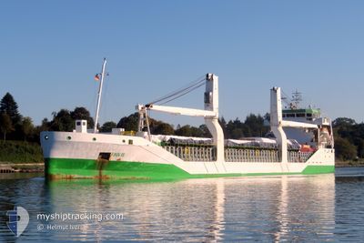
FINN III
General Cargo
Current Trip
| Trip Time | 10 days |
|---|---|
| Trip Distance | 2246.68 nm |
| AVG Speed | 9.9 Knop |
| MAX Speed | 14.5 Knop |
| Djupgående | 8.2 m |
| AVG Wind | 12.8 knots |
| MAX Wind | 36.9 knots |
| MIN Temp | 4.1°C / 39.38°F |
| MAX Temp | 20.9°C / 69.62°F |
| Position mottagen | 4 d sen |
Current Position
| Longitud | --- |
|---|---|
| Latitude | --- |
| Status | Under way using engine |
| Fart | 11.8 Knop |
| Kurs | 117.7° |
| Område | Mediterranean Sea - Western Basin |
| Station | T-AIS |
| Position mottagen | 4 d sen |
Info
Information
The current position of FINN III is in Mediterranean Sea - Western Basin with coordinates 36.99574° / 4.81757° as reported on 2024-11-18 03:08 by AIS to our vessel tracker app. The vessel's current speed is 11.8 Knop and is currently inside the port of BEJAIA.
The vessel FINN III (IMO: 9534456, MMSI: 305166000) is a General Cargo that was built in 2011 ( 13 År gammal ). It's sailing under the flag of [AG] Antigua Barbuda.
In this page you can find informations about the vessels current position, last detected port calls, and current voyage information. If the vessels is not in coverage by AIS you will find the latest position.
The current position of FINN III is detected by our AIS receivers and we are not responsible for the reliability of the data. The last position was recorded while the vessel was in Coverage by the Ais receivers of our vessel tracking app.
The current draught of FINN III as reported by AIS is 8.2 meters
Weather
| Temperature | 19.9°C / 67.82°F |
|---|---|
| Wind Speed | 9 knots |
| Direction | 281° W |
| Pressure | 1016 hPa |
| Humidity | 51.9 % |
| Cloud Coverage | 70 % |
Featured Company
Last Port Calls
| Port | Arrival | Departure | Time In Port |
|---|---|---|---|
| 2024-11-20 04:33 | |||
| 2024-11-09 16:47 | 2024-11-09 17:36 | 48 m | |
| 2024-11-05 08:02 | 2024-11-07 09:12 | 2 d | |
| 2024-11-04 09:57 | 2024-11-04 10:52 | 54 m | |
| 2024-11-01 09:12 | 2024-11-01 09:49 | 36 m | |
| 2024-10-20 07:15 | 2024-10-21 17:56 | 1 d | |
| 2024-10-16 06:10 | 2024-10-18 22:25 | 2 d | |
| 2024-09-28 09:21 | 2024-10-02 09:33 | 4 d | |
| 2024-09-26 17:20 | 2024-09-26 18:02 | 42 m | |
| 2024-09-23 17:45 | 2024-09-23 18:24 | 38 m |
Last Trips
| Origin | Departure | Destination | Arrival | Distance | |
|---|---|---|---|---|---|
| 2024-11-09 18:36 | 2024-11-20 05:33 | 2246.68 nm | |||
| 2024-11-07 10:12 | 2024-11-09 17:47 | 636.96 nm | |||
| 2024-11-04 11:52 | 2024-11-05 09:02 | 261.25 nm | |||
| 2024-11-01 10:49 | 2024-11-04 10:57 | 48.31 nm | |||
| 2024-10-21 19:56 | 2024-11-01 10:12 | 2574.70 nm | |||
| 2024-10-18 23:25 | 2024-10-20 09:15 | 126.30 nm | |||
| 2024-10-02 12:33 | 2024-10-16 07:10 | 2701.09 nm | |||
| 2024-09-26 20:02 | 2024-09-28 12:21 | 358.06 nm | |||
| 2024-09-23 20:24 | 2024-09-26 19:20 | 48.49 nm | |||
| 2024-09-13 19:32 | 2024-09-23 19:45 | 2558.95 nm |
Events
| Tid | Event | Detaljer | Position / Dest | Information |
|---|---|---|---|---|
| 2024-11-20 04:49 | STOPPAR förflyttning |
36.75050 / 5.08671
[DZ] BEJAIA
|
Fart: 0.2 kn Kurs: 234° |
|
| 2024-11-20 04:33 | ANLÄNDER HAMN |
|
36.75080 / 5.09336
[DZ] BEJAIA
|
Fart: 4.9 kn Kurs: 301° |
| 2024-11-20 03:51 | STARTAR förflyttning | 3.25 nm, South East of BEJAIA |
36.72046 / 5.15013
DZBJA
|
Fart: 4.9 kn Kurs: 291° |
| 2024-11-18 05:48 | STOPPAR förflyttning | 3.52 nm, South East of BEJAIA |
36.71982 / 5.15646
DZBJA
|
Fart: 0.3 kn Kurs: 203° |
| 2024-11-18 03:17 | Status ändrad | Default Under way using engine |
36.98260 / 4.84863
DZBJA
|
Fart: 11.8 kn Kurs: 117.7° |
| 2024-11-18 03:08 | UTANFÖR täckningsområde |
36.99574 / 4.81757
Mediterranean Sea - Western Basin
DZBJA
|
Fart: 11.8 kn Kurs: 117.7° |
|
| 2024-11-18 03:05 | Status ändrad | Under way using engine Default |
37.00082 / 4.80544
DZBJA
|
Fart: 11.9 kn Kurs: 117° |
| 2024-11-18 02:45 | Status ändrad | Default Under way using engine |
37.03133 / 4.73074
DZBJA
|
Fart: 11.9 kn Kurs: 100.6° |
| 2024-11-18 02:36 | Status ändrad | Under way using engine Default |
37.04052 / 4.69640
DZBJA
|
Fart: 11.9 kn Kurs: 99° |
| 2024-11-18 02:19 | I täckningsområde |
37.03983 / 4.70113
Mediterranean Sea - Western Basin
DZBJA
|
Fart: 11.9 kn Kurs: 100.3° |