

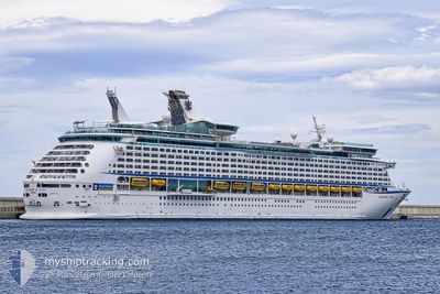
EXPLORER OF THE SEAS
Passengers Ship

Current Trip
| Time Travelled | 7 h, 39 mins |
|---|---|
| Remaining Time | --- |
| Distance Travelled | --- |
| Remaining Distance | --- |
| AVG Speed | --- |
| MAX Speed | --- |
| AVG Wind | --- |
| MAX Wind | --- |
| MIN Temp | --- |
| MAX Temp | --- |
| Djupgående | 9.1 m |
| Position mottagen | 2 d sen |
Current Position
| Longitud | --- |
|---|---|
| Latitude | --- |
| Status | Under way using engine |
| Fart | 15.4 Knop |
| Kurs | 194.6° |
| Område | Caribbean Sea |
| Station | T-AIS |
| Position mottagen | 2 d sen |
Information
The current position of EXPLORER OF THE SEAS is in Caribbean Sea with coordinates 20.35637° / -87.08062° as reported on 2025-02-18 23:26 by AIS to our vessel tracker app. The vessel's current speed is 15.4 Knop
The vessel EXPLORER OF THE SEAS (IMO: 9161728, MMSI: 311316000) is a Passengers Ship that was built in 2000 ( 25 År gammal ). It's sailing under the flag of [BS] Bahamas.
In this page you can find informations about the vessels current position, last detected port calls, and current voyage information. If the vessels is not in coverage by AIS you will find the latest position.
The current position of EXPLORER OF THE SEAS is detected by our AIS receivers and we are not responsible for the reliability of the data. The last position was recorded while the vessel was in Coverage by the Ais receivers of our vessel tracking app.
The current draught of EXPLORER OF THE SEAS as reported by AIS is 9.1 meters
Weather
| Temperature | 26.7°C / 80.06°F |
|---|---|
| Wind Speed | 14 knots |
| Direction | 47° NE |
| Pressure | 1016.4 hPa |
| Humidity | 77 % |
| Cloud Coverage | 100 % |


Featured Company
Last Port Calls
| Port | Arrival | Departure | Time In Port |
|---|---|---|---|
| 2025-02-20 13:22 | 2025-02-20 22:59 | 9 h | |
| 2025-02-19 13:27 | 2025-02-19 23:40 | 10 h | |
| 2025-02-18 11:37 | 2025-02-18 22:40 | 11 h | |
| 2025-02-16 10:38 | 2025-02-16 22:26 | 11 h | |
| 2025-02-13 12:02 | 2025-02-13 20:51 | 8 h | |
| 2025-02-12 11:11 | 2025-02-12 21:49 | 10 h | |
| 2025-02-11 11:33 | 2025-02-11 21:40 | 10 h | |
| 2025-02-10 11:41 | 2025-02-10 21:47 | 10 h | |
| 2025-02-06 10:06 | 2025-02-06 21:37 | 11 h | |
| 2025-01-31 12:33 | 2025-01-31 22:03 | 9 h |
Last Trips
| Origin | Departure | Destination | Arrival | Distance | |
|---|---|---|---|---|---|
| 2025-02-19 17:40 | 2025-02-20 07:22 | 122.12 nm | |||
| 2025-02-18 17:40 | 2025-02-19 07:27 | 213.21 nm | |||
| 2025-02-16 17:26 | 2025-02-18 06:37 | 523.82 nm | |||
| 2025-02-13 16:51 | 2025-02-16 05:38 | 1135.95 nm | |||
| 2025-02-12 17:49 | 2025-02-13 08:02 | 100.48 nm | |||
| 2025-02-11 17:40 | 2025-02-12 07:11 | 141.50 nm | |||
| 2025-02-10 17:47 | 2025-02-11 07:33 | 198.89 nm | |||
| 2025-02-06 16:37 | 2025-02-10 07:41 | 1127.87 nm | |||
| 2025-01-31 17:03 | 2025-02-06 05:06 | 1859.44 nm | |||
| 2025-01-30 16:09 | 2025-01-31 07:33 | 278.84 nm |
Events
| Tid | Event | Detaljer | Position / Dest | Information |
|---|---|---|---|---|
| 2025-02-20 22:59 | AVGÅTT HAMN |
|
16.26431 / -86.58521
BELIZE
|
Fart: 6.7 kn Kurs: 212° |
| 2025-02-20 22:57 | STARTAR förflyttning |
16.30249 / -86.55362
[HN] ROATAN
|
Fart: 6.7 kn Kurs: 212° |
|
| 2025-02-20 13:46 | STOPPAR förflyttning |
16.31215 / -86.54443
[HN] ROATAN
|
Fart: Kurs: 99° |
|
| 2025-02-20 13:22 | ANLÄNDER HAMN |
|
16.31215 / -86.54443
[HN] ROATAN
|
Fart: 6.1 kn Kurs: 30° |
| 2025-02-19 23:40 | AVGÅTT HAMN |
|
17.41942 / -88.15777
BELIZE
|
Fart: 8.5 kn Kurs: 245° |
| 2025-02-19 13:58 | STOPPAR förflyttning |
17.44342 / -88.12301
[BZ] BELIZE CITY
|
Fart: 0.3 kn Kurs: 66° |
|
| 2025-02-19 13:27 | ANLÄNDER HAMN |
|
17.43178 / -88.14446
[BZ] BELIZE CITY
|
Fart: 10.3 kn Kurs: 41° |
| 2025-02-18 23:26 | UTANFÖR täckningsområde |
20.35637 / -87.08062
Caribbean Sea
BELIZE
|
Fart: 15.4 kn Kurs: 194.6° |
|
| 2025-02-18 22:40 | AVGÅTT HAMN |
|
20.48627 / -86.97741
BELIZE
|
Fart: 3.9 kn Kurs: 296° |
| 2025-02-18 22:37 | STARTAR förflyttning |
20.48429 / -86.97536
[MX] COZUMEL
|
Fart: 3.4 kn Kurs: 354° |