
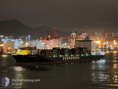
EVER BRACE
Cargo D
Current Trip
| Time Travelled | 1 day |
|---|---|
| Remaining Time | --- |
| Distance Travelled | 229.18 nm |
| Remaining Distance | --- |
| AVG Speed | 12.5 Knop |
| MAX Speed | 16.5 Knop |
| AVG Wind | 7.9 knots |
| MAX Wind | 12.5 knots |
| MIN Temp | 23.1°C / 73.58°F |
| MAX Temp | 24.4°C / 75.92°F |
| Djupgående | 11 m |
| Position mottagen | 1 m sen |
Current Position
| Longitud | --- |
|---|---|
| Latitude | --- |
| Status | Under way using engine |
| Fart | 15.2 Knop |
| Kurs | 173.7° |
| Område | Gulf of Oman |
| Station | T-AIS |
| Position mottagen | 1 m sen |
Info
Information
The current position of EVER BRACE is in Gulf of Oman with coordinates 25.14886° / 56.75782° as reported on 2025-03-18 01:00 by AIS to our vessel tracker app. The vessel's current speed is 15.2 Knop and is heading at the port of KOCHI. The estimated time of arrival as calculated by MyShipTracking vessel tracking app is 2025-03-21 17:00 LT
The vessel EVER BRACE (IMO: 9784116, MMSI: 357413000) is a Cargo D It's sailing under the flag of [PA] Panama.
In this page you can find informations about the vessels current position, last detected port calls, and current voyage information. If the vessels is not in coverage by AIS you will find the latest position.
The current position of EVER BRACE is detected by our AIS receivers and we are not responsible for the reliability of the data. The last position was recorded while the vessel was in Coverage by the Ais receivers of our vessel tracking app.
The current draught of EVER BRACE as reported by AIS is 11 meters
Weather
| Temperature | 24°C / 75.2°F |
|---|---|
| Wind Speed | 6 knots |
| Direction | 256° WSW |
| Pressure | 1012.4 hPa |
| Humidity | 58.3 % |
| Cloud Coverage | --- |
Featured Company
Last Port Calls
| Port | Arrival | Departure | Time In Port |
|---|---|---|---|
| 2025-03-15 12:07 | 2025-03-17 01:07 | 1 d | |
| 2025-03-09 18:43 | 2025-03-10 11:08 | 16 h | |
| 2025-03-07 22:11 | 2025-03-08 15:35 | 17 h | |
| 2025-03-04 17:39 | 2025-03-06 03:51 | 1 d | |
| 2025-03-01 19:11 | 2025-03-03 03:03 | 1 d | |
| 2025-02-27 01:27 | 2025-02-28 00:27 | 22 h | |
| 2025-02-19 16:32 | 2025-02-21 19:39 | 2 d | |
| 2025-02-14 22:15 | 2025-02-15 15:03 | 16 h | |
| 2025-02-12 21:31 | 2025-02-14 02:03 | 1 d | |
| 2025-02-09 13:23 | 2025-02-10 22:19 | 1 d |
Last Trips
| Origin | Departure | Destination | Arrival | Distance | |
|---|---|---|---|---|---|
| 2025-03-10 11:08 | 2025-03-15 12:07 | 1687.47 nm | |||
| 2025-03-08 15:35 | 2025-03-09 18:43 | 334.42 nm | |||
| 2025-03-06 03:51 | 2025-03-07 22:11 | 611.13 nm | |||
| 2025-03-03 03:03 | 2025-03-04 17:39 | 610.23 nm | |||
| 2025-02-28 00:27 | 2025-03-01 19:11 | 318.65 nm | |||
| 2025-02-21 19:39 | 2025-02-27 01:27 | 1671.36 nm | |||
| 2025-02-15 15:03 | 2025-02-19 16:32 | 1659.84 nm | |||
| 2025-02-14 02:03 | 2025-02-14 22:15 | 328.88 nm | |||
| 2025-02-10 22:19 | 2025-02-12 21:31 | 619.79 nm | |||
| 2025-02-07 06:27 | 2025-02-09 13:23 | 612.67 nm |
Events
| Tid | Event | Detaljer | Position / Dest | Information |
|---|---|---|---|---|
| 2025-03-17 23:01 | Byter havsområde | United Arab Emirates part of the Gulf of Oman Omani part of the Gulf of Oman |
25.66043 / 56.75189
Gulf of Oman
AEJEA > INCOK
|
Fart: 15.5 kn Kurs: 179.2° |
| 2025-03-17 22:02 | Byter havsområde | Omani part of the Gulf of Oman Omani part of the Persian Gulf |
25.91300 / 56.74096
Gulf of Oman
AEJEA > INCOK
|
Fart: 15.3 kn Kurs: 175.4° |
| 2025-03-17 22:01 | Status ändrad | Under way using engine Default |
25.91674 / 56.74065
AEJEA > INCOK
|
Fart: 15.3 kn Kurs: 176° |
| 2025-03-17 21:49 | I täckningsområde |
25.91300 / 56.74096
Gulf of Oman
AEJEA > INCOK
|
Fart: 15.3 kn Kurs: 175.4° |
|
| 2025-03-17 16:48 | Status ändrad | Default Under way using engine |
26.24368 / 55.97396
AEJEA > INCOK
|
Fart: 15.7 kn Kurs: 56.8° |
| 2025-03-17 16:38 | UTANFÖR täckningsområde |
26.22031 / 55.93350
Persian Gulf
AEJEA > INCOK
|
Fart: 15.7 kn Kurs: 56.8° |
|
| 2025-03-17 16:26 | Byter havsområde | Omani part of the Persian Gulf United Arab Emirates part of the Persian Gulf |
26.18702 / 55.88587
Persian Gulf
AEJEA > INCOK
|
Fart: 15.7 kn Kurs: 50.8° |
| 2025-03-17 11:37 | STARTAR förflyttning | 14.37 nm, North West of JUMEIRAH |
25.34147 / 55.02201
AEJEA > INCOK
|
Fart: 3.7 kn Kurs: 267° |
| 2025-03-17 11:25 | Status ändrad | Under way using engine At anchor |
25.34281 / 55.02493
AEJEA > INCOK
|
Fart: 0.7 kn Kurs: 185° |
| 2025-03-17 07:55 | Status ändrad | At anchor Default |
25.34399 / 55.02649
AEJEA > INCOK
|
Fart: 0.1 kn Kurs: 236° |