
ESL WAFA
Container Ship
Current Trip
Unknown
| Time Travelled | --- |
|---|---|
| Remaining Time | --- |
| Distance Travelled | --- |
| Remaining Distance | --- |
| AVG Speed | --- |
| MAX Speed | --- |
| AVG Wind | --- |
| MAX Wind | --- |
| MIN Temp | --- |
| MAX Temp | --- |
| Djupgående | 14.4 m |
| Position mottagen | 5 d sen |
Current Position
| Longitud | 103.55802° |
|---|---|
| Latitude | 1.20653° |
| Status | Under way using engine |
| Fart | 13 Knop |
| Kurs | 279.4° |
| Område | Singapore Strait |
| Station | T-AIS |
| Position mottagen | 5 d sen |
Info
Information
The current position of ESL WAFA is in Singapore Strait with coordinates 1.20653° / 103.55802° as reported on 2024-05-07 08:12 by AIS to our vessel tracker app. The vessel's current speed is 13 Knop
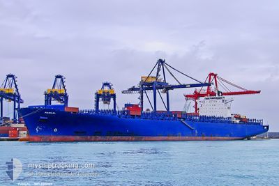
The vessel ESL WAFA (IMO: 9306160, MMSI: 255915789) is a Container Ship that was built in 2006 ( 18 År gammal ). It's sailing under the flag of [PT] Portugal.
In this page you can find informations about the vessels current position, last detected port calls, and current voyage information. If the vessels is not in coverage by AIS you will find the latest position.
The current position of ESL WAFA is detected by our AIS receivers and we are not responsible for the reliability of the data. The last position was recorded while the vessel was in Coverage by the Ais receivers of our vessel tracking app.
The current draught of ESL WAFA as reported by AIS is 14.4 meters
Weather
| Temperature | 29.4°C / 84.92°F |
|---|---|
| Wind Speed | 6 knots |
| Direction | 163° SSE |
| Pressure | 1007.5 hPa |
| Humidity | 70.4 % |
| Cloud Coverage | 19 % |
Featured Company
Last Port Calls
Most Visited Ports (Last year)
| Port | Arrivals |
|---|
Last Trips
| Origin | Departure | Destination | Arrival | Distance |
|---|
Events
| Tid | Event | Detaljer | Position / Dest | Information |
|---|---|---|---|---|
| 2024-05-07 08:12 | UTANFÖR täckningsområde |
1.20653 / 103.55802
Singapore Strait
PORT KLANG
|
Fart: 13 kn Kurs: 279.4° |
|
| 2024-05-07 08:04 | Byter havsområde | Malaysian part of the Singapore Strait Indonesian part of the Singapore Strait |
1.19970 / 103.58710
Singapore Strait
PORT KLANG
|
Fart: 13.2 kn Kurs: 283.9° |
| 2024-05-07 07:34 | Byter havsområde | Indonesian part of the Singapore Strait Singaporean part of the Singapore Strait |
1.16663 / 103.68777
Singapore Strait
PORT KLANG
|
Fart: 13.2 kn Kurs: 301.3° |
| 2024-05-07 05:46 | Upptäckt i hav | Singaporean part of the Singapore Strait |
1.25542 / 103.99515
Singapore Strait
PORT KLANG
|
Fart: 12.8 kn Kurs: 258.9° |
| 2024-05-07 05:22 | Byter havsområde | Indonesian part of the Singapore Strait Malaysian part of the Singapore Strait |
1.26962 / 104.07972
Singapore Strait
PORT KLANG
|
Fart: 12.8 kn Kurs: 260.8° |
| 2024-05-07 05:04 | ETA ändrat | 2024/05/08 06:30 2024/05/07 21:00 |
1.27862 / 104.14715
PORT KLANG
|
Fart: 13.5 kn Kurs: 264.8° |
| 2024-05-07 04:30 | Byter havsområde | Malaysian part of the Singapore Strait Chinese part of the South China Sea |
1.29857 / 104.26812
Singapore Strait
PORT KLANG
|
Fart: 12.9 kn Kurs: 254.2° |
| 2024-05-07 04:29 | I täckningsområde |
1.29857 / 104.26812
Singapore Strait
PORT KLANG
|
Fart: 12.9 kn Kurs: 254.2° |
|
| 2024-05-03 04:16 | UTANFÖR täckningsområde |
22.10602 / 114.29825
South China Sea
PORT KLANG
|
Fart: 14.1 kn Kurs: 105.3° |
|
| 2024-05-03 04:11 | I täckningsområde |
22.10865 / 114.28762
South China Sea
PORT KLANG
|
Fart: 14 kn Kurs: 99.8° |