
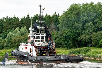
EN AVANT 10
Tug
Current Trip
Current Position
| Longitud | --- |
|---|---|
| Latitude | --- |
| Status | Restricted manoeuverability |
| Fart | 6.7 Knop |
| Kurs | 159° |
| Område | Baltic Sea |
| Station | T-AIS |
| Position mottagen | 1 m sen |
Information
The current position of EN AVANT 10 is in Baltic Sea with coordinates 54.17522° / 12.09589° as reported on 2025-03-29 07:24 by AIS to our vessel tracker app. The vessel's current speed is 6.7 Knop and is currently inside the port of ROSTOCK.
The vessel EN AVANT 10 (IMO: 9264386, MMSI: 246774000) is a Tug that was built in 2002 ( 23 År gammal ). It's sailing under the flag of [NL] Netherlands.
In this page you can find informations about the vessels current position, last detected port calls, and current voyage information. If the vessels is not in coverage by AIS you will find the latest position.
The current position of EN AVANT 10 is detected by our AIS receivers and we are not responsible for the reliability of the data. The last position was recorded while the vessel was in Coverage by the Ais receivers of our vessel tracking app.
Weather
| Temperature | 6.5°C / 43.7°F |
|---|---|
| Wind Speed | 11 knots |
| Direction | 337° NNW |
| Pressure | 1012.4 hPa |
| Humidity | 93 % |
| Cloud Coverage | 100 % |
Featured Company
Last Trips
| Origin | Departure | Destination | Arrival | Distance | |
|---|---|---|---|---|---|
| 2025-03-24 13:36 | 2025-03-29 08:17 | 706.17 nm | |||
| 2025-03-05 09:36 | 2025-03-09 17:31 | 694.51 nm | |||
| 2025-02-24 14:55 | 2025-03-01 10:46 | 691.02 nm | |||
| 2025-02-04 08:54 | 2025-02-09 12:44 | 725.46 nm | |||
| 2025-01-10 08:47 | 2025-01-15 10:24 | 698.40 nm |
Events
| Tid | Event | Detaljer | Position / Dest | Information |
|---|---|---|---|---|
| 2025-03-29 07:24 | Status ändrad | Restricted manoeuverability Under way using engine |
54.17642 / 12.09515
[DE] ROSTOCK
|
Fart: 6.5 kn Kurs: 159° |
| 2025-03-29 07:24 | Status ändrad | Under way using engine Restricted manoeuverability |
54.17661 / 12.09502
[DE] ROSTOCK
|
Fart: 6.6 kn Kurs: 159° |
| 2025-03-29 07:17 | ANLÄNDER HAMN |
|
54.18819 / 12.08873
[DE] ROSTOCK
|
Fart: 6.5 kn Kurs: 163.4° |
| 2025-03-29 04:16 | Upptäckt i hav | German part of the Baltic Sea |
54.36330 / 11.84944
Baltic Sea
DERSK
|
Fart: 5.4 kn Kurs: 136.5° |
| 2025-03-29 01:04 | Byter havsområde | Danish part of the Baltic Sea German part of the Baltic Sea |
54.51530 / 11.41638
Baltic Sea
DERSK
|
Fart: 5.2 kn Kurs: 117.6° |
| 2025-03-28 22:07 | Upptäckt i hav | German part of the Baltic Sea |
54.64003 / 11.02283
Baltic Sea
DERSK
|
Fart: 5.7 kn Kurs: 123.1° |
| 2025-03-28 20:31 | Byter havsområde | Danish part of the Baltic Sea Danish part of the Kattegat |
54.73953 / 10.85812
Baltic Sea
DERSK
|
Fart: 5.4 kn Kurs: 176.6° |
| 2025-03-28 05:41 | Status ändrad | Restricted manoeuverability Under way using engine |
55.97933 / 11.02265
DERSK
|
Fart: 6.1 kn Kurs: 211.6° |
| 2025-03-28 05:41 | Status ändrad | Under way using engine Restricted manoeuverability |
55.97954 / 11.02289
DERSK
|
Fart: 6.1 kn Kurs: 211.5° |
| 2025-03-27 21:01 | ETA ändrat | 2025/03/29 07:00 2025/03/29 09:00 |
56.65633 / 11.77427
DERSK
|
Fart: 5.5 kn Kurs: 214.9° |