
DAYDREAM BELIEVER
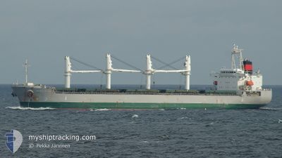
Bulk Carrier
Current Trip
| Trip Time | 4 days |
|---|---|
| Trip Distance | 1015.37 nm |
| AVG Speed | 9.4 Knop |
| MAX Speed | 14.7 Knop |
| Djupgående | 6.4 m |
| AVG Wind | 11.7 knots |
| MAX Wind | 21.6 knots |
| MIN Temp | 16.8°C / 62.24°F |
| MAX Temp | 25°C / 77°F |
| Position mottagen | 2 d sen |
Current Position
| Longitud | 120.33086° |
|---|---|
| Latitude | 24.33972° |
| Status | Under way using engine |
| Fart | 10.5 Knop |
| Kurs | 177.8° |
| Område | South China Sea |
| Station | T-AIS |
| Position mottagen | 2 d sen |
Info
Information
The current position of DAYDREAM BELIEVER is in South China Sea with coordinates 24.33972° / 120.33086° as reported on 2024-05-10 16:35 by AIS to our vessel tracker app. The vessel's current speed is 10.5 Knop and is currently inside the port of TAICHUNG.
The vessel DAYDREAM BELIEVER (IMO: 9605982, MMSI: 538004493) is a Bulk Carrier that was built in 2012 ( 12 År gammal ). It's sailing under the flag of [MH] Marshall Is.
In this page you can find informations about the vessels current position, last detected port calls, and current voyage information. If the vessels is not in coverage by AIS you will find the latest position.
The current position of DAYDREAM BELIEVER is detected by our AIS receivers and we are not responsible for the reliability of the data. The last position was recorded while the vessel was in Coverage by the Ais receivers of our vessel tracking app.
The current draught of DAYDREAM BELIEVER as reported by AIS is 6.4 meters
Weather
| Temperature | 22.9°C / 73.22°F |
|---|---|
| Wind Speed | 26 knots |
| Direction | 25° NNE |
| Pressure | 1010.6 hPa |
| Humidity | 70 % |
| Cloud Coverage | 99 % |
Featured Company
Most Visited Ports (Last year)
| Port | Arrivals | |
|---|---|---|
| 3 | ||
| 2 | ||
| 2 | ||
| 1 | ||
| 1 | ||
| 1 |
Last Trips
Events
| Tid | Event | Detaljer | Position / Dest | Information |
|---|---|---|---|---|
| 2024-05-10 19:19 | STOPPAR förflyttning |
24.23097 / 120.48262
[TW] TAICHUNG
|
Fart: 0.1 kn Kurs: 21° |
|
| 2024-05-10 17:56 | ANLÄNDER HAMN |
|
24.29107 / 120.50362
[TW] TAICHUNG
|
Fart: 8.9 kn Kurs: 74° |
| 2024-05-10 16:40 | Status ändrad | Default Under way using engine |
24.32505 / 120.33140
JP MIZ
|
Fart: 10.5 kn Kurs: 177.8° |
| 2024-05-10 16:35 | Status ändrad | Under way using engine Default |
24.33972 / 120.33086
JP MIZ
|
Fart: 10.5 kn Kurs: 177° |
| 2024-05-10 16:35 | UTANFÖR täckningsområde |
24.33972 / 120.33086
South China Sea
|
Fart: 10.5 kn Kurs: 177.8° |
|
| 2024-05-10 16:33 | Status ändrad | Default Under way using engine |
24.34803 / 120.33051
JP MIZ
|
Fart: 10.6 kn Kurs: 179.1° |
| 2024-05-10 16:13 | Status ändrad | Under way using engine Default |
24.40617 / 120.32830
JP MIZ
|
Fart: 10.5 kn Kurs: 178° |
| 2024-05-10 16:08 | Status ändrad | Default Under way using engine |
24.41945 / 120.32784
JP MIZ
|
Fart: 10.3 kn Kurs: 192.2° |
| 2024-05-10 15:58 | Status ändrad | Under way using engine Default |
24.44848 / 120.33044
JP MIZ
|
Fart: 9.7 kn Kurs: 194° |
| 2024-05-10 15:40 | Byter havsområde | Taiwanese part of the South China Sea Taiwanese part of the Eastern China Sea |
24.48843 / 120.34067
South China Sea
|
Fart: 8.6 kn Kurs: 193.4° |