
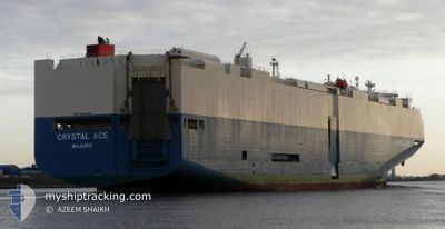
CRYSTAL ACE
Vehicles Carrier
Current Trip
| Trip Time | 2 days |
|---|---|
| Trip Distance | 305.01 nm |
| AVG Speed | 7.5 Knop |
| MAX Speed | 7.5 Knop |
| Djupgående | 8.3 m |
| AVG Wind | 13.5 knots |
| MAX Wind | 27.2 knots |
| MIN Temp | 20.2°C / 68.36°F |
| MAX Temp | 25.3°C / 77.54°F |
| Position mottagen | 1 m sen |
Current Position
| Longitud | -81.53548° |
|---|---|
| Latitude | 31.13204° |
| Status | Under way using engine |
| Fart | |
| Kurs | 134° |
| Område | North Atlantic Ocean |
| Station | T-AIS |
| Position mottagen | 1 m sen |
Info
Information
The current position of CRYSTAL ACE is in North Atlantic Ocean with coordinates 31.13204° / -81.53548° as reported on 2024-05-11 12:46 by AIS to our vessel tracker app. The vessel's current speed is 0 Knop and is currently inside the port of BRUNSWICK.
The vessel CRYSTAL ACE (IMO: 9539224, MMSI: 538004619) is a Vehicles Carrier that was built in 2012 ( 12 År gammal ). It's sailing under the flag of [MH] Marshall Is.
In this page you can find informations about the vessels current position, last detected port calls, and current voyage information. If the vessels is not in coverage by AIS you will find the latest position.
The current position of CRYSTAL ACE is detected by our AIS receivers and we are not responsible for the reliability of the data. The last position was recorded while the vessel was in Coverage by the Ais receivers of our vessel tracking app.
The current draught of CRYSTAL ACE as reported by AIS is 8.3 meters
Weather
| Temperature | 17.2°C / 62.96°F |
|---|---|
| Wind Speed | 4 knots |
| Direction | 5° N |
| Pressure | 1011.6 hPa |
| Humidity | 87.7 % |
| Cloud Coverage | 40 % |
Featured Company
Last Port Calls
| Port | Arrival | Departure | Time In Port |
|---|---|---|---|
| 2024-05-10 11:26 | |||
| 2024-05-07 00:46 | 2024-05-07 17:42 | 16 h | |
| 2024-05-04 00:10 | 2024-05-04 22:24 | 22 h | |
| 2024-05-02 06:56 | 2024-05-02 21:03 | 14 h | |
| 2024-04-24 15:10 | 2024-04-26 09:18 | 1 d | |
| 2024-04-22 10:06 | 2024-04-22 18:39 | 8 h | |
| 2024-03-30 05:26 | 2024-03-31 16:02 | 1 d | |
| 2024-03-27 21:49 | 2024-03-28 21:23 | 23 h | |
| 2024-03-26 21:05 | 2024-03-27 14:25 | 17 h | |
| 2024-03-24 23:36 | 2024-03-26 07:26 | 1 d |
Last Trips
| Origin | Departure | Destination | Arrival | Distance | |
|---|---|---|---|---|---|
| 2024-05-07 13:42 | 2024-05-10 07:26 | 305.01 nm | |||
| 2024-05-04 18:24 | 2024-05-06 20:46 | 636.59 nm | |||
| 2024-05-02 17:03 | 2024-05-03 20:10 | 280.12 nm | |||
| 2024-04-26 04:18 | 2024-05-02 02:56 | 1768.70 nm | |||
| 2024-04-22 14:39 | 2024-04-24 10:10 | 475.91 nm | |||
| 2024-04-01 01:02 | 2024-04-22 06:06 | 8606.16 nm | |||
| 2024-03-29 06:23 | 2024-03-30 14:26 | 534.11 nm | |||
| 2024-03-27 23:25 | 2024-03-28 06:49 | 95.27 nm | |||
| 2024-03-26 16:26 | 2024-03-27 06:05 | 174.77 nm | |||
| 2024-02-23 12:36 | 2024-03-25 08:36 | 10776.90 nm |
Events
| Tid | Event | Detaljer | Position / Dest | Information |
|---|---|---|---|---|
| 2024-05-11 09:49 | Status ändrad | Under way using engine Default |
31.13205 / -81.53548
[US] BRUNSWICK
|
Fart: Kurs: 134° |
| 2024-05-11 09:49 | I täckningsområde |
31.13205 / -81.53548
North Atlantic Ocean
[US] BRUNSWICK
|
Fart: Kurs: 41.3° |
|
| 2024-05-11 02:33 | Status ändrad | Default Under way using engine |
31.13214 / -81.53547
[US] BRUNSWICK
|
Fart: Kurs: 134° |
| 2024-05-11 02:27 | UTANFÖR täckningsområde |
31.13210 / -81.53544
North Atlantic Ocean
[US] BRUNSWICK
|
Fart: Kurs: 83° |
|
| 2024-05-10 12:28 | Status ändrad | Under way using engine Default |
31.13202 / -81.53547
[US] BRUNSWICK
|
Fart: 0.2 kn Kurs: 134° |
| 2024-05-10 12:28 | I täckningsområde |
31.13202 / -81.53547
North Atlantic Ocean
[US] BRUNSWICK
|
Fart: Kurs: 169° |
|
| 2024-05-10 12:13 | STOPPAR förflyttning |
31.13206 / -81.53546
[US] BRUNSWICK
|
Fart: 0.2 kn Kurs: 134° |
|
| 2024-05-10 11:26 | ANLÄNDER HAMN |
|
31.12432 / -81.50704
[US] BRUNSWICK
|
Fart: 12.5 kn Kurs: 255° |
| 2024-05-10 10:42 | Status ändrad | Default Under way using engine |
31.11546 / -81.36043
US SSI
|
Fart: 13.8 kn Kurs: 304.4° |
| 2024-05-10 10:24 | UTANFÖR täckningsområde |
31.07959 / -81.29738
North Atlantic Ocean
US SSI
|
Fart: 13.8 kn Kurs: 304.4° |