
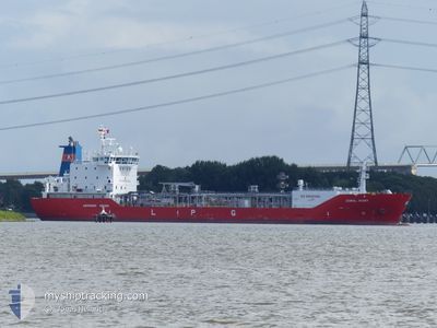
CORAL IVORY
Lpg Tanker
Current Trip
| Time Travelled | 22 h, 46 mins |
|---|---|
| Remaining Time | 11 h, 32 mins |
| Distance Travelled | 334.24 nm |
| Remaining Distance | 176.08 nm |
| AVG Speed | 13.6 Knop |
| MAX Speed | 16.2 Knop |
| AVG Wind | 13.7 knots |
| MAX Wind | 21.2 knots |
| MIN Temp | -9.7°C / 14.54°F |
| MAX Temp | 2.6°C / 36.68°F |
| Djupgående | 5.3 m |
| Position mottagen | 1 m sen |
Current Position
| Longitud | --- |
|---|---|
| Latitude | --- |
| Status | Under way using engine |
| Fart | 15.3 Knop |
| Kurs | 250.8° |
| Område | Baltic Sea |
| Station | T-AIS |
| Position mottagen | 1 m sen |
Info
Information
The current position of CORAL IVORY is in Baltic Sea with coordinates 54.86936° / 13.16456° as reported on 2026-01-06 01:13 by AIS to our vessel tracker app. The vessel's current speed is 15.3 Knop and is heading at the port of BRUNSBUETTEL. The estimated time of arrival as calculated by MyShipTracking vessel tracking app is 2026-01-06 12:47 LT
The vessel CORAL IVORY (IMO: 9207039, MMSI: 245286000) is a Lpg Tanker that was built in 2000 ( 26 År gammal ). It's sailing under the flag of [NL] Netherlands.
In this page you can find informations about the vessels current position, last detected port calls, and current voyage information. If the vessels is not in coverage by AIS you will find the latest position.
The current position of CORAL IVORY is detected by our AIS receivers and we are not responsible for the reliability of the data. The last position was recorded while the vessel was in Coverage by the Ais receivers of our vessel tracking app.
The current draught of CORAL IVORY as reported by AIS is 5.3 meters
Weather
| Temperature | 0.4°C / 32.72°F |
|---|---|
| Wind Speed | 10 knots |
| Direction | 231° SW |
| Pressure | 1010.9 hPa |
| Humidity | 82.7 % |
| Cloud Coverage | 100 % |
Featured Company
Last Port Calls
| Port | Arrival | Departure | Time In Port |
|---|---|---|---|
| 2026-01-05 01:43 | 2026-01-05 02:29 | 46 m | |
| 2026-01-02 12:26 | 2026-01-04 19:40 | 2 d | |
| 2026-01-02 06:20 | 2026-01-02 06:42 | 21 m | |
| 2025-12-29 21:23 | 2025-12-30 11:43 | 14 h | |
| 2025-12-29 11:38 | 2025-12-29 12:26 | 48 m | |
| 2025-12-27 13:30 | 2025-12-27 14:07 | 36 m | |
| 2025-12-25 11:27 | 2025-12-27 07:21 | 1 d | |
| 2025-12-25 04:21 | 2025-12-25 04:48 | 27 m | |
| 2025-12-22 03:42 | 2025-12-22 19:17 | 15 h | |
| 2025-12-21 18:56 | 2025-12-21 20:16 | 1 h |
Last Trips
| Origin | Departure | Destination | Arrival | Distance | |
|---|---|---|---|---|---|
| 2026-01-04 20:40 | 2026-01-05 02:43 | 66.70 nm | |||
| 2026-01-02 07:42 | 2026-01-02 13:26 | 65.96 nm | |||
| 2025-12-30 12:43 | 2026-01-02 07:20 | 523.22 nm | |||
| 2025-12-29 13:26 | 2025-12-29 22:23 | 49.87 nm | |||
| 2025-12-27 15:07 | 2025-12-29 12:38 | 466.73 nm | |||
| 2025-12-27 08:21 | 2025-12-27 14:30 | 66.41 nm | |||
| 2025-12-25 05:48 | 2025-12-25 12:27 | 65.84 nm | |||
| 2025-12-22 20:17 | 2025-12-25 05:21 | 517.97 nm | |||
| 2025-12-21 21:16 | 2025-12-22 04:42 | 49.82 nm | |||
| 2025-12-19 20:33 | 2025-12-21 19:56 | 467.68 nm |
Events
| Tid | Event | Detaljer | Position / Dest | Information |
|---|---|---|---|---|
| 2026-01-05 23:37 | Byter havsområde | German part of the Baltic Sea Swedish part of the Baltic Sea |
55.01069 / 13.81134
Baltic Sea
DEBRB
|
Fart: 14.8 kn Kurs: 245.2° |
| 2026-01-05 20:43 | Byter havsområde | Swedish part of the Baltic Sea Danish part of the Kattegat |
55.48210 / 14.71577
Baltic Sea
DEBRB
|
Fart: 14.5 kn Kurs: 251.6° |
| 2026-01-05 19:25 | Upptäckt i hav | Danish part of the Kattegat |
55.64547 / 15.21069
Kattegat
DEBRB
|
Fart: 15.5 kn Kurs: 240.5° |
| 2026-01-05 18:06 | ETA ändrat | 2026/01/06 08:00 2026/01/06 05:00 |
55.81057 / 15.73089
DEBRB
|
Fart: 16 kn Kurs: 241.7° |
| 2026-01-05 17:50 | Status ändrad | Under way using engine Default |
55.84465 / 15.84122
DEBRB
|
Fart: 15.7 kn Kurs: 241° |
| 2026-01-05 17:45 | I täckningsområde |
55.84465 / 15.84122
Baltic Sea
DEBRB
|
Fart: 15.8 kn Kurs: 240.6° |
|
| 2026-01-05 10:41 | Status ändrad | Default Under way using engine |
57.33111 / 17.58781
DEBRB
|
Fart: 15.4 kn Kurs: 200.3° |
| 2026-01-05 10:40 | UTANFÖR täckningsområde |
57.33353 / 17.58939
Baltic Sea
DEBRB
|
Fart: 15.4 kn Kurs: 200.3° |
|
| 2026-01-05 08:10 | Status ändrad | Under way using engine Default |
57.93762 / 17.77201
DEBRB
|
Fart: 14 kn Kurs: 184° |
| 2026-01-05 08:09 | Status ändrad | Default Under way using engine |
57.94309 / 17.77274
DEBRB
|
Fart: 14.1 kn Kurs: 183.2° |