

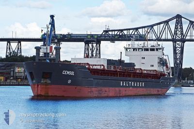
CEMSOL
Cement Carrier

Current Trip
| Time Travelled | 10 h, 38 mins |
|---|---|
| Remaining Time | 12 h, 7 mins |
| Distance Travelled | 117.72 nm |
| Remaining Distance | 140.26 nm |
| AVG Speed | 11.3 Knop |
| MAX Speed | 11.7 Knop |
| AVG Wind | 8.6 knots |
| MAX Wind | 12.7 knots |
| MIN Temp | 4°C / 39.2°F |
| MAX Temp | 5°C / 41°F |
| Djupgående | 6.1 m |
| Position mottagen | 10 h, 12 m sen |
Current Position
| Longitud | --- |
|---|---|
| Latitude | --- |
| Status | Under way using engine |
| Fart | 11 Knop |
| Kurs | 286.7° |
| Område | Baltic Sea |
| Station | T-AIS |
| Position mottagen | 10 h, 12 m sen |
Information
The current position of CEMSOL is in Baltic Sea with coordinates 55.75109° / 20.95952° as reported on 2025-03-26 09:11 by AIS to our vessel tracker app. The vessel's current speed is 11 Knop and is heading at the port of OXELOSUND. The estimated time of arrival as calculated by MyShipTracking vessel tracking app is 2025-03-27 08:30 LT
The vessel CEMSOL (IMO: 9180401, MMSI: 212360000) is a Cement Carrier that was built in 1998 ( 27 År gammal ). It's sailing under the flag of [CY] Cyprus.
In this page you can find informations about the vessels current position, last detected port calls, and current voyage information. If the vessels is not in coverage by AIS you will find the latest position.
The current position of CEMSOL is detected by our AIS receivers and we are not responsible for the reliability of the data. The last position was recorded while the vessel was in Coverage by the Ais receivers of our vessel tracking app.
The current draught of CEMSOL as reported by AIS is 6.1 meters
Weather
| Temperature | 4°C / 39.2°F |
|---|---|
| Wind Speed | 10 knots |
| Direction | 359° N |
| Pressure | 1017.2 hPa |
| Humidity | 94 % |
| Cloud Coverage | 98 % |


Featured Company
Last Port Calls
| Port | Arrival | Departure | Time In Port |
|---|---|---|---|
| 2025-03-25 05:23 | 2025-03-26 10:45 | 1 d | |
| 2025-03-22 18:31 | 2025-03-24 00:15 | 1 d | |
| 2025-03-20 14:30 | 2025-03-21 20:14 | 1 d | |
| 2025-03-14 19:42 | 2025-03-16 11:18 | 1 d | |
| 2025-02-22 20:44 | 2025-03-14 01:30 | 19 d | |
| 2025-02-18 12:16 | 2025-02-20 15:32 | 2 d | |
| 2025-02-15 19:33 | 2025-02-17 11:57 | 1 d | |
| 2025-02-13 07:47 | 2025-02-14 15:35 | 1 d | |
| 2025-02-10 20:29 | 2025-02-12 02:53 | 1 d | |
| 2025-02-08 00:37 | 2025-02-09 07:48 | 1 d |
Last Trips
| Origin | Departure | Destination | Arrival | Distance | |
|---|---|---|---|---|---|
| 2025-03-24 00:15 | 2025-03-25 05:23 | 305.16 nm | |||
| 2025-03-21 20:14 | 2025-03-22 18:31 | 253.38 nm | |||
| 2025-03-16 11:18 | 2025-03-20 14:30 | 670.79 nm | |||
| 2025-03-14 01:30 | 2025-03-14 19:42 | 151.09 nm | |||
| 2025-02-20 15:32 | 2025-02-22 20:44 | 412.58 nm | |||
| 2025-02-17 11:57 | 2025-02-18 12:16 | 252.62 nm | |||
| 2025-02-14 15:35 | 2025-02-15 19:33 | 306.87 nm | |||
| 2025-02-12 02:53 | 2025-02-13 07:47 | 314.54 nm | |||
| 2025-02-09 07:48 | 2025-02-10 20:29 | 346.26 nm | |||
| 2025-02-05 23:08 | 2025-02-08 00:37 | 359.73 nm |
Events
| Tid | Event | Detaljer | Position / Dest | Information |
|---|---|---|---|---|
| 2025-03-26 09:28 | Status ändrad | Default Under way using engine |
55.76598 / 20.87189
SEOXE
|
Fart: 11 kn Kurs: 286.7° |
| 2025-03-26 09:11 | UTANFÖR täckningsområde |
55.75109 / 20.95952
Baltic Sea
SEOXE
|
Fart: 11 kn Kurs: 286.7° |
|
| 2025-03-26 08:45 | AVGÅTT HAMN |
|
55.72643 / 21.08907
SEOXE
|
Fart: 7.3 kn Kurs: 290° |
| 2025-03-26 08:24 | STARTAR förflyttning |
55.69481 / 21.12946
[LT] KLAIPEDA
|
Fart: 3.6 kn Kurs: 302° |
|
| 2025-03-26 07:39 | Status ändrad | Under way using engine Moored |
55.69606 / 21.13190
[LT] KLAIPEDA
|
Fart: Kurs: 338° |
| 2025-03-26 07:39 | Djupgående ändrat | 6.1 4.6 |
55.69606 / 21.13190
[LT] KLAIPEDA
|
Fart: Kurs: 338° |
| 2025-03-26 07:39 | Destination ändrad | SEOXE LTKLJ |
55.69606 / 21.13190
[LT] KLAIPEDA
|
Fart: Kurs: 338° |
| 2025-03-26 07:39 | ETA ändrat | 2025/03/27 11:00 2025/03/25 05:00 |
55.69606 / 21.13190
[LT] KLAIPEDA
|
Fart: Kurs: 338° |
| 2025-03-26 07:33 | Status ändrad | Moored Default |
55.69606 / 21.13191
[LT] KLAIPEDA
|
Fart: Kurs: 338° |
| 2025-03-26 07:30 | Status ändrad | Default Moored |
55.69606 / 21.13190
[LT] KLAIPEDA
|
Fart: Kurs: 338° |