

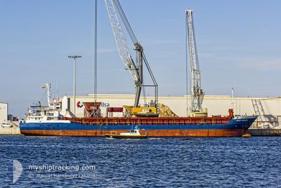
CELTIC ENDEAVOUR
General Cargo

Current Trip
| Time Travelled | 1 day |
|---|---|
| Remaining Time | --- |
| Distance Travelled | 299.67 nm |
| Remaining Distance | --- |
| AVG Speed | 9.8 Knop |
| MAX Speed | 12.9 Knop |
| AVG Wind | 5.9 knots |
| MAX Wind | 15 knots |
| MIN Temp | 12.3°C / 54.14°F |
| MAX Temp | 15.9°C / 60.62°F |
| Djupgående | 6.1 m |
| Position mottagen | 1 m sen |
Current Position
| Longitud | --- |
|---|---|
| Latitude | --- |
| Status | Under way using engine |
| Fart | 9.7 Knop |
| Kurs | 347.4° |
| Område | North Atlantic Ocean |
| Station | T-AIS |
| Position mottagen | 1 m sen |
Information
The current position of CELTIC ENDEAVOUR is in North Atlantic Ocean with coordinates 38.40568° / -9.76060° as reported on 2025-03-03 04:02 by AIS to our vessel tracker app. The vessel's current speed is 9.7 Knop and is heading at the port of ELLESMERE. The estimated time of arrival as calculated by MyShipTracking vessel tracking app is 2025-03-07 14:00 LT
The vessel CELTIC ENDEAVOUR (IMO: 9346706, MMSI: 305924000) is a General Cargo that was built in 2009 ( 16 År gammal ). It's sailing under the flag of [AG] Antigua Barbuda.
In this page you can find informations about the vessels current position, last detected port calls, and current voyage information. If the vessels is not in coverage by AIS you will find the latest position.
The current position of CELTIC ENDEAVOUR is detected by our AIS receivers and we are not responsible for the reliability of the data. The last position was recorded while the vessel was in Coverage by the Ais receivers of our vessel tracking app.
The current draught of CELTIC ENDEAVOUR as reported by AIS is 6.1 meters
Weather
| Temperature | 12.1°C / 53.78°F |
|---|---|
| Wind Speed | 12 knots |
| Direction | 76° ENE |
| Pressure | 1011.5 hPa |
| Humidity | 82.6 % |
| Cloud Coverage | 96 % |


Featured Company
Last Port Calls
| Port | Arrival | Departure | Time In Port |
|---|---|---|---|
| 2025-03-01 18:13 | 2025-03-01 21:59 | 3 h | |
| 2025-02-14 08:23 | 2025-02-21 16:15 | 7 d | |
| 2025-02-10 05:59 | 2025-02-12 12:50 | 2 d | |
| 2025-02-03 11:29 | 2025-02-03 14:58 | 3 h | |
| 2025-01-31 06:15 | 2025-01-31 19:59 | 13 h | |
| 2025-01-25 11:15 | 2025-01-28 20:25 | 3 d | |
| 2025-01-16 10:32 | 2025-01-18 11:27 | 2 d | |
| 2025-01-12 13:29 | 2025-01-15 12:53 | 2 d | |
| 2025-01-06 22:11 |
Most Visited Ports (Last year)
| Port | Arrivals | |
|---|---|---|
| 5 | ||
| 5 | ||
| 3 | ||
| 3 | ||
| 3 | ||
| 3 |
Last Trips
| Origin | Departure | Destination | Arrival | Distance | |
|---|---|---|---|---|---|
| 2025-02-21 19:15 | 2025-03-01 19:13 | 1790.17 nm | |||
| 2025-02-12 14:50 | 2025-02-14 11:23 | 339.87 nm | |||
| 2025-02-03 15:58 | 2025-02-10 07:59 | 1552.84 nm | |||
| 2025-01-31 20:59 | 2025-02-03 12:29 | 579.59 nm | |||
| 2025-01-28 21:25 | 2025-01-31 07:15 | 437.37 nm | |||
| 2025-01-18 12:27 | 2025-01-25 12:15 | 1591.42 nm | |||
| 2025-01-15 13:53 | 2025-01-16 11:32 | 251.87 nm | |||
| 2025-01-06 22:11 | 2025-01-12 14:29 | 1395.12 nm |
Events
| Tid | Event | Detaljer | Position / Dest | Information |
|---|---|---|---|---|
| 2025-03-02 23:43 | Byter havsområde | Portuguese part of the North Atlantic Ocean Spanish part of the Strait of Gibraltar |
37.72075 / -9.55777
North Atlantic Ocean
GBELL
|
Fart: 9.7 kn Kurs: 348.2° |
| 2025-03-02 23:43 | Status ändrad | Under way using engine Default |
37.72075 / -9.55777
GBELL
|
Fart: 9.9 kn Kurs: 350° |
| 2025-03-02 23:23 | I täckningsområde |
37.72075 / -9.55777
North Atlantic Ocean
GBELL
|
Fart: 9.7 kn Kurs: 348.2° |
|
| 2025-03-02 00:51 | Status ändrad | Default Under way using engine |
35.95885 / -5.76588
GBELL
|
Fart: 12.9 kn Kurs: 271.8° |
| 2025-03-02 00:51 | Status ändrad | Under way using engine Default |
35.95884 / -5.76507
GBELL
|
Fart: 12.3 kn Kurs: 271° |
| 2025-03-02 00:51 | UTANFÖR täckningsområde |
35.95884 / -5.76507
Strait of Gibraltar
GBELL
|
Fart: 12.9 kn Kurs: 271.8° |
|
| 2025-03-02 00:39 | Status ändrad | Default Under way using engine |
35.95667 / -5.71333
GBELL
|
Fart: 11.4 kn Kurs: 267.2° |
| 2025-03-01 23:09 | Byter havsområde | Spanish part of the Strait of Gibraltar Moroccan part of the Strait of Gibraltar |
35.98874 / -5.41502
Strait of Gibraltar
GBELL
|
Fart: 9 kn Kurs: 300.2° |
| 2025-03-01 23:02 | Byter havsområde | Moroccan part of the Strait of Gibraltar Spanish part of the Strait of Gibraltar |
35.97975 / -5.39532
Strait of Gibraltar
GBELL
|
Fart: 8.9 kn Kurs: 299° |
| 2025-03-01 23:02 | Djupgående ändrat | 6.1 6 |
35.97937 / -5.39447
GBELL
|
Fart: 8.8 kn Kurs: 300.1° |