

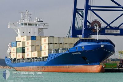
BREEZE
Container Ship

Current Trip
| Time Travelled | 19 h, 10 mins |
|---|---|
| Remaining Time | --- |
| Distance Travelled | 31.28 nm |
| Remaining Distance | 576.90 nm |
| AVG Speed | 12.6 Knop |
| MAX Speed | 13.6 Knop |
| AVG Wind | 12.4 knots |
| MAX Wind | 16 knots |
| MIN Temp | 24.6°C / 76.28°F |
| MAX Temp | 26.2°C / 79.16°F |
| Djupgående | 7.5 m |
| Position mottagen | 7 d sen |
Current Position
| Longitud | --- |
|---|---|
| Latitude | --- |
| Status | Under way using engine |
| Fart | 11.9 Knop |
| Kurs | 187.9° |
| Område | North Atlantic Ocean |
| Station | T-AIS |
| Position mottagen | 7 d sen |
Information
The current position of BREEZE is in North Atlantic Ocean with coordinates 25.56639° / -79.58178° as reported on 2025-02-20 13:41 by AIS to our vessel tracker app. The vessel's current speed is 11.9 Knop and is heading at the port of MARIEL. The estimated time of arrival as calculated by MyShipTracking vessel tracking app is 2025-02-21 11:00 LT
The vessel BREEZE (IMO: 9389423, MMSI: 305291000) is a Container Ship that was built in 2008 ( 17 År gammal ). It's sailing under the flag of [AG] Antigua Barbuda.
In this page you can find informations about the vessels current position, last detected port calls, and current voyage information. If the vessels is not in coverage by AIS you will find the latest position.
The current position of BREEZE is detected by our AIS receivers and we are not responsible for the reliability of the data. The last position was recorded while the vessel was in Coverage by the Ais receivers of our vessel tracking app.
The current draught of BREEZE as reported by AIS is 7.5 meters
Weather
| Temperature | 26°C / 78.8°F |
|---|---|
| Wind Speed | 3 knots |
| Direction | 332° NNW |
| Pressure | 1015.3 hPa |
| Humidity | 65.5 % |
| Cloud Coverage | --- |


Featured Company
Last Port Calls
| Port | Arrival | Departure | Time In Port |
|---|---|---|---|
| 2025-02-26 07:31 | 2025-02-26 21:51 | 14 h | |
| 2025-02-23 19:11 | 2025-02-24 06:39 | 11 h | |
| 2025-02-18 02:33 | 2025-02-19 00:15 | 21 h | |
| 2025-02-16 18:19 | 2025-02-17 01:43 | 7 h | |
| 2025-02-15 03:17 | 2025-02-15 19:38 | 16 h | |
| 2025-02-15 02:53 | 2025-02-15 03:01 | 7 m | |
| 2025-02-10 18:47 | 2025-02-11 11:40 | 16 h | |
| 2025-02-08 21:41 | 2025-02-08 21:56 | 15 m | |
| 2025-02-07 17:35 | 2025-02-08 17:31 | 23 h | |
| 2025-02-03 22:49 | 2025-02-04 14:44 | 15 h |
Most Visited Ports (Last year)
| Port | Arrivals | |
|---|---|---|
| 45 | ||
| 43 | ||
| 40 | ||
| 5 | ||
| 4 | ||
| 2 |
Last Trips
| Origin | Departure | Destination | Arrival | Distance | |
|---|---|---|---|---|---|
| 2025-02-24 01:39 | 2025-02-26 01:31 | 597.30 nm | |||
| 2025-02-18 19:15 | 2025-02-23 14:11 | 917.36 nm | |||
| 2025-02-16 20:43 | 2025-02-17 21:33 | 323.58 nm | |||
| 2025-02-15 14:38 | 2025-02-16 13:19 | 317.66 nm | |||
| 2025-02-14 22:01 | 2025-02-14 22:17 | 0.87 nm | |||
| 2025-02-11 05:40 | 2025-02-14 21:53 | 854.17 nm | |||
| 2025-02-08 15:56 | 2025-02-10 12:47 | 2.09 nm | |||
| 2025-02-08 11:31 | 2025-02-08 15:41 | 60.20 nm | |||
| 2025-02-04 09:44 | 2025-02-07 11:35 | 861.46 nm | |||
| 2025-02-01 09:59 | 2025-02-03 17:49 | 820.30 nm |
Events
| Tid | Event | Detaljer | Position / Dest | Information |
|---|---|---|---|---|
| 2025-02-27 03:33 | STOPPAR förflyttning | 2.51 nm, West of PUERTO CORTES |
15.82006 / -87.98772
CUMAR
|
Fart: Kurs: 97° |
| 2025-02-26 21:51 | AVGÅTT HAMN |
|
15.70592 / -88.61873
CUMAR
|
Fart: 3.7 kn Kurs: 4° |
| 2025-02-26 21:47 | STARTAR förflyttning |
15.69764 / -88.61939
[GT] PUERTO SANTO TOMAS
|
Fart: 3.7 kn Kurs: 4° |
|
| 2025-02-26 07:31 | STOPPAR förflyttning |
15.69521 / -88.61928
[GT] PUERTO SANTO TOMAS
|
Fart: 0.2 kn Kurs: 63° |
|
| 2025-02-26 07:31 | ANLÄNDER HAMN |
|
15.69521 / -88.61928
[GT] PUERTO SANTO TOMAS
|
Fart: 0.9 kn Kurs: 54° |
| 2025-02-26 06:35 | STARTAR förflyttning | 4.95 nm, North of PUERTO BARRIOS |
15.81827 / -88.59628
CUMAR
|
Fart: 6.5 kn Kurs: 205° |
| 2025-02-25 22:59 | STOPPAR förflyttning | 5.16 nm, North of PUERTO BARRIOS |
15.82159 / -88.59473
CUMAR
|
Fart: 0.2 kn Kurs: 91° |
| 2025-02-24 06:39 | AVGÅTT HAMN |
|
23.04124 / -82.76476
CUMAR
|
Fart: 6.4 kn Kurs: 4° |
| 2025-02-23 19:26 | STOPPAR förflyttning |
23.00556 / -82.76311
[CU] MARIEL
|
Fart: Kurs: 234° |
|
| 2025-02-23 19:11 | ANLÄNDER HAMN |
|
23.00592 / -82.75959
[CU] MARIEL
|
Fart: 9.3 kn Kurs: 185° |