
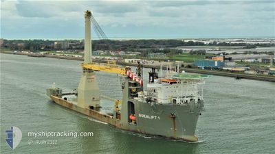
BOKALIFT1
Heavy Lift Vessel
Current Trip
| Time Travelled | 6 days |
|---|---|
| Remaining Time | --- |
| Distance Travelled | 1625.44 nm |
| Remaining Distance | --- |
| AVG Speed | 10.4 Knop |
| MAX Speed | 14.3 Knop |
| AVG Wind | 16.5 knots |
| MAX Wind | 27.3 knots |
| MIN Temp | 7.2°C / 44.96°F |
| MAX Temp | 13.8°C / 56.84°F |
| Djupgående | 8 m |
| Position mottagen | 4 d sen |
Current Position
| Longitud | -4.39542° |
|---|---|
| Latitude | 49.67200° |
| Status | Under way using engine |
| Fart | 11.5 Knop |
| Kurs | 250.9° |
| Område | English Channel |
| Station | T-AIS |
| Position mottagen | 4 d sen |
Info
Information
The current position of BOKALIFT1 is in English Channel with coordinates 49.67200° / -4.39542° as reported on 2024-04-22 08:18 by AIS to our vessel tracker app. The vessel's current speed is 11.5 Knop and is heading at the port of PROVIDENCE. The estimated time of arrival as calculated by MyShipTracking vessel tracking app is 2024-05-02 06:00 LT
The vessel BOKALIFT1 (IMO: 9592850, MMSI: 212827000) is a Heavy Lift Vessel that was built in 2012 ( 12 År gammal ). It's sailing under the flag of [CY] Cyprus.
In this page you can find informations about the vessels current position, last detected port calls, and current voyage information. If the vessels is not in coverage by AIS you will find the latest position.
The current position of BOKALIFT1 is detected by our AIS receivers and we are not responsible for the reliability of the data. The last position was recorded while the vessel was in Coverage by the Ais receivers of our vessel tracking app.
The current draught of BOKALIFT1 as reported by AIS is 8 meters
Weather
| Temperature | 13.9°C / 57.02°F |
|---|---|
| Wind Speed | 9 knots |
| Direction | 29° NNE |
| Pressure | 1027.6 hPa |
| Humidity | 69.3 % |
| Cloud Coverage | 16 % |
Featured Company
Events
| Tid | Event | Detaljer | Position / Dest | Information |
|---|---|---|---|---|
| 2024-04-23 08:02 | STARTAR förflyttning |
48.04500 / -10.29833
PROVIDENCE
|
Fart: 6 kn Kurs: 180° |
|
| 2024-04-23 07:41 | STOPPAR förflyttning |
48.05333 / -10.29833
PROVIDENCE
|
Fart: Kurs: -1° |
|
| 2024-04-22 08:26 | Status ändrad | Default Under way using engine |
49.66365 / -4.43209
PROVIDENCE
|
Fart: 11.5 kn Kurs: 250.9° |
| 2024-04-22 08:18 | UTANFÖR täckningsområde |
49.67200 / -4.39542
English Channel
PROVIDENCE
|
Fart: 11.5 kn Kurs: 250.9° |
|
| 2024-04-22 07:37 | Status ändrad | Under way using engine Default |
49.71322 / -4.20482
PROVIDENCE
|
Fart: 11.1 kn Kurs: 252° |
| 2024-04-22 07:34 | Status ändrad | Default Under way using engine |
49.71637 / -4.19031
PROVIDENCE
|
Fart: 11.1 kn Kurs: 251.8° |
| 2024-04-22 06:19 | Status ändrad | Under way using engine Default |
49.78562 / -3.86366
PROVIDENCE
|
Fart: 10.1 kn Kurs: 252° |
| 2024-04-22 06:19 | Status ändrad | Default Under way using engine |
49.78633 / -3.86025
PROVIDENCE
|
Fart: 10.1 kn Kurs: 251.9° |
| 2024-04-22 03:33 | Byter havsområde | United Kingdom part of the English Channel Guernsey part of the English Channel |
49.93606 / -3.16836
English Channel
PROVIDENCE
|
Fart: 10.9 kn Kurs: 251.2° |
| 2024-04-22 03:33 | Status ändrad | Under way using engine Default |
49.93638 / -3.16687
PROVIDENCE
|
Fart: 10.9 kn Kurs: 251° |