
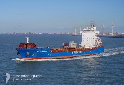
BG SAPPHIRE
Cargo
Current Trip
| Time Travelled | 1 day |
|---|---|
| Remaining Time | 2 h, 11 mins |
| Distance Travelled | 702.16 nm |
| Remaining Distance | 30.98 nm |
| AVG Speed | 14.4 Knop |
| MAX Speed | 17.7 Knop |
| AVG Wind | 19.5 knots |
| MAX Wind | 28.8 knots |
| MIN Temp | 1.8°C / 35.24°F |
| MAX Temp | 10.5°C / 50.9°F |
| Djupgående | 8 m |
| Position mottagen | 1 m sen |
Current Position
| Longitud | --- |
|---|---|
| Latitude | --- |
| Status | Under way using engine |
| Fart | 8.1 Knop |
| Kurs | 346.1° |
| Område | Irish Sea and St. George's Channel |
| Station | T-AIS |
| Position mottagen | 1 m sen |
Info
Information
The current position of BG SAPPHIRE is in Irish Sea and St. George's Channel with coordinates 54.46702° / -5.37262° as reported on 2025-02-18 14:21 by AIS to our vessel tracker app. The vessel's current speed is 8.1 Knop and is heading at the port of BELFAST. The estimated time of arrival as calculated by MyShipTracking vessel tracking app is 2025-02-18 16:33 LT
The vessel BG SAPPHIRE (IMO: 9803699, MMSI: 209247000) is a Cargo It's sailing under the flag of [CY] Cyprus.
In this page you can find informations about the vessels current position, last detected port calls, and current voyage information. If the vessels is not in coverage by AIS you will find the latest position.
The current position of BG SAPPHIRE is detected by our AIS receivers and we are not responsible for the reliability of the data. The last position was recorded while the vessel was in Coverage by the Ais receivers of our vessel tracking app.
The current draught of BG SAPPHIRE as reported by AIS is 8 meters
Weather
| Temperature | 5.7°C / 42.26°F |
|---|---|
| Wind Speed | 26 knots |
| Direction | 131° SE |
| Pressure | 1016.6 hPa |
| Humidity | 75.3 % |
| Cloud Coverage | 100 % |
Featured Company
Last Port Calls
| Port | Arrival | Departure | Time In Port |
|---|---|---|---|
| 2025-02-15 17:35 | 2025-02-16 16:04 | 22 h | |
| 2025-02-14 09:49 | 2025-02-15 16:03 | 1 d | |
| 2025-02-09 22:51 | 2025-02-13 00:45 | 3 d | |
| 2025-02-04 05:30 | 2025-02-07 16:59 | 3 d | |
| 2025-02-03 22:30 | 2025-02-04 04:09 | 5 h | |
| 2025-02-03 22:23 | |||
| 2025-02-01 23:10 | 2025-02-03 20:08 | 1 d | |
| 2025-01-31 07:34 | 2025-01-31 07:35 | 0 m | |
| 2025-01-29 21:32 | 2025-01-31 07:23 | 1 d | |
| 2025-01-29 20:47 | 2025-01-29 20:56 | 8 m |
Most Visited Ports (Last year)
| Port | Arrivals | |
|---|---|---|
| 66 | ||
| 41 | ||
| 20 | ||
| 19 | ||
| 10 | ||
| 9 |
Last Trips
| Origin | Departure | Destination | Arrival | Distance | |
|---|---|---|---|---|---|
| 2025-02-15 17:03 | 2025-02-15 18:35 | 16.26 nm | |||
| 2025-02-13 00:45 | 2025-02-14 10:49 | 398.91 nm | |||
| 2025-02-07 17:59 | 2025-02-09 22:51 | 398.19 nm | |||
| 2025-02-04 05:09 | 2025-02-04 06:30 | 15.24 nm | |||
| 2025-02-03 21:08 | 2025-02-03 23:30 | 16.91 nm | |||
| 2025-02-03 21:08 | 2025-02-03 23:23 | 16.84 nm | |||
| 2025-01-31 07:35 | 2025-02-02 00:10 | 576.27 nm | |||
| 2025-01-29 20:56 | 2025-01-29 21:32 | 3.26 nm | |||
| 2025-01-28 17:59 | 2025-01-29 20:47 | 372.33 nm | |||
| 2025-01-25 14:31 | 2025-01-25 23:21 | 154.29 nm |
Events
| Tid | Event | Detaljer | Position / Dest | Information |
|---|---|---|---|---|
| 2025-02-18 14:10 | Byter havsområde | United Kingdom part of the Inner Seas off the West Coast of Scotland United Kingdom part of the Irish Sea and St. George's Channel |
54.43313 / -5.35945
Inner Seas off the West Coast of Scotland
BELFAST
|
Fart: 13.2 kn Kurs: 346.5° |
| 2025-02-18 11:50 | Status ändrad | Under way using engine Default |
53.91977 / -5.44125
BELFAST
|
Fart: 13.5 kn Kurs: 4° |
| 2025-02-18 11:47 | Status ändrad | Default Under way using engine |
53.90848 / -5.44267
BELFAST
|
Fart: 13.5 kn Kurs: 4.4° |
| 2025-02-18 11:42 | Status ändrad | Under way using engine Default |
53.88885 / -5.44520
BELFAST
|
Fart: 13.8 kn Kurs: 4° |
| 2025-02-18 11:39 | Status ändrad | Default Under way using engine |
53.87813 / -5.44657
BELFAST
|
Fart: 13.7 kn Kurs: 3.5° |
| 2025-02-18 11:39 | Status ändrad | Under way using engine Default |
53.87489 / -5.44695
BELFAST
|
Fart: 13.7 kn Kurs: 4° |
| 2025-02-18 11:27 | Status ändrad | Default Under way using engine |
53.83242 / -5.45243
BELFAST
|
Fart: 13.8 kn Kurs: 4° |
| 2025-02-18 11:14 | Byter havsområde | United Kingdom part of the Irish Sea and St. George's Channel Irish part of the Irish Sea and St. George's Channel |
53.77950 / -5.45912
Irish Sea and St. George's Channel
BELFAST
|
Fart: 13.8 kn Kurs: 3° |
| 2025-02-18 06:16 | Byter havsområde | Irish part of the Irish Sea and St. George's Channel United Kingdom part of the Celtic Sea |
52.58465 / -5.69207
Irish Sea and St. George's Channel
BELFAST
|
Fart: 14.3 kn Kurs: 5.7° |
| 2025-02-18 06:16 | Status ändrad | Under way using engine Default |
52.58465 / -5.69207
BELFAST
|
Fart: 14.2 kn Kurs: 6° |